|
||

|

|
|

|
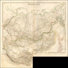
The Most Accurate Chart of Hong Kong and The Pearl River Delta During the First Opium War
Rare British Admiralty sea chart of mouth of the Pearl River from Macao Island to Hong Kong and the New Territories, published in March 1840.
The chart depicts the results of a survey conducted by Captain Daniel Ross of the Bombay Marine in 1815. Ross's survey was the most detailed and accurate chartihg of Hong Kong and environs of the period. In Daniel Ross was directed to survey the China Seas by the East India Company in 1807. He spent the next 13 years surveying the Chinese Coastline and other parts of the China Sea and contiguous waters and become the de facto British expert in the region.
Ross's surveys were not widely published until the First Opium War (1839 - 1842), when his work was used as the base information for the present chart, which was revised and improved the work of Captain I. A. Douglas, who had been deployed fighting Chinese piracy in the region and whose work resulted in an improved survey of the region in 1839, at the outset of the First Opium War. Placenames reference in the area of Hong Kong include Pirate Bay, Woody Islet, Bluff Point, Tytam, Fishhouse, and Junk Town.
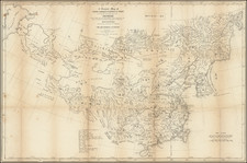
Ross's chart was reissued in March, 1840 at the outset war, prior to the taking of Hong Kong by Commodore Bremmer in 1841 and the publication of Sir Edward Belcher's chart of the island first issued in 1843, which was based upon Belcher's survey of Hong Konga after landing his vessel the H.M.S. Sulphur on Possession Point on January, 26, 1841.,
Captain Ross's survey of the region, together with Belcher's 1841 manuscripts, were used to negotiate the 1842 Treaty of Nanking at the conclusion of the first Opium War, which resulted in the British colonization of Hong Kong.
Captain Daniel Ross
Ross joined the Bombay Marine in 1795. Between 1806 and 1820 he was engaged in surveying the coast of China: he made surveys of part of the Bohai Sea and of Guangdong, as well as some of the eastern islands. His election as a Fellow of the Royal Society in 1822 reflected the reputation which he had acquired during that period.
In 1823, Ross was appointed Marine Surveyor General at Calcutta and remained in that position until he resigned his appointment in November 1833. After his resignation he retired to Bombay, where he was Master Attendant, and was appointed President of the Geographical Society of Bombay in 1838. Following his retirement as President on grounds of ill-health in 1849, shortly before his death, the Bombay Geographical Society appointed him Honorary President. The minutes of the Society record that:
Captain Ross had established for himself a European reputation of a high order, as one of the most practical and correct of Eastern Hydrographers; and the fortunes of many merchants, and the lives of many mariners, have been saved by the results of his patient and scientific labors.
Rarity
Ross's chart is of the utmost rarity. OCLC lists only the example in the British Library. We are aware of only 1 other example on the market in the past 10 years.
The British Admiralty has produced nautical charts since 1795 under the auspices of the United Kingdom Hydrographic Office (HO). Its main task was to provide the Royal Navy with navigational products and service, but since 1821 it has also sold charts to the public.
In 1795, King George III appointed Alexander Dalrymple, a pedantic geographer, to consolidate, catalogue, and improve the Royal Navy’s charts. He produced the first chart as the Hydrographer to the Admiralty in 1802. Dalrymple, known for his sticky personality, served until his death in 1808, when he was succeeded by Captain Thomas Hurd. The HO has been run by naval officers ever since.
Hurd professionalized the office and increased its efficiency. He was succeeded by the Arctic explorer Captain William Parry in 1823. By 1825, the HO was offering over seven hundred charts and views for sale. Under Parry, the HO also began to participate in exploratory expeditions. The first was a joint French-Spanish-British trip to the South Atlantic, a voyage organized in part by the Royal Society of London.
In 1829, Rear-Admiral Sir Francis Beaufort was appointed Hydrographer Royal. Under his management, the HO introduced the wind force scale named for him, as well as began issuing official tide tables (1833). It was under Beaufort that HMS Beagle completed several surveying missions, including its most famous voyage commanded by Captain FitzRoy with Charles Darwin onboard. When Beaufort retired in 1855, the HO had nearly two thousand charts in its catalog.
Later in the nineteenth century, the HO supported the Challenger expedition, which is credited with helping to found the discipline of oceanography. The HO participated in the International Meridian Conference which decided on the Greenwich Meridian as the Prime Meridian. Regulation and standardization of oceanic and navigational measures continued into the twentieth century, with the HO participating at the first International Hydrographic Organization meeting in 1921.
During World War II, the HO chart making facility moved to Taunton, the first purpose-built building it ever inhabited. In 1953, the first purpose-built survey ship went to sea, the HMS Vidal. Today, there is an entire class of survey vessels that make up the Royal Navy’s Hydrographic Squadron. The HO began to computerize their charts in the late 1960s and early 1970s. In 1968, the compilation staff also came to Taunton, and the HO continues to work from there today.