|
||

|

|
|

|
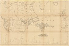
One of the Earliest Maps To Illustrate A Transcontinental Railroad
Fine map of the United States, prepared by famed Architect Robert Mills, designer of the Washington Monument and author of the first American State Atlas, the Atlas of the State of South Carolina, published in 1825.
This map accompanied one of the first government reports setting forth a prospective Transmississippi Railroad, just months after the end of the Mexican War.
Prepared by Robert Mills, Engineer & Architect, the map proposes a route from Van Buren (Ft. Smith), Arkansas, to San Diego, via El Paso, Texas and the Gila River. Ironically, the Southern Route would become the final of the three major transcontinental railroad routes and would find its terminus in California via San Bernardino and Los Angeles. San Diego did not finally see through service to the east until the completion of the San Diego & Arizona Railroad was completed on November 15,1919, over 70 years after the current map was published.
Ancillary map is a small scale world map showing the position of the American transcontinental railroad to the shipping pattern between North America and Europe, Asia, Australia, and Pacific Islands. Sheet also includes an elevational profile of the proposed route from Little Rock to San Diego, the route from Reynosa to El Paso del Norte, and the route from El Paso via Santa Fe to Independence.
Originally included in a report by John A. Rockwell, entitled:
Canal or railroad between the Atlantic and Pacific oceans. Compiled from the reconnaissance of Col. Fremont, Lt. Col. Emory, Dr. Wislizenus & others. Ancillary map is of the world comparing the position of our continent with Europe, Africa and Asia.


![Colton's United States Shewing Military Stations, Forts &c. . . . 1861 [Shows Slave, Free and Border States -- Printed For British Market]](https://storage.googleapis.com/raremaps/img/small/103234.jpg)