


|
||

|

|
|

|
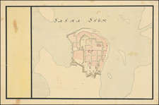
Planning For Fires In 18th Century Stockholm
Rare plan of Stockholm, engraved by Georg Biurman in Stockholm.
At the top left, the map includes a table which includes flag signals according to the Royal Regulation of December 28, 1728, which was intended to assist with warnings in the event of fires. The map shows the symbols of a city-wide alert system for fires. These “Bransignaler”—described in the upper right of the map —used a system of flags, lanterns, church bells, and cannon shots to communicate where the fire was occurring within five regions of the area. Coming so soon after the Klarabranden, this map reminds its viewers to be prepared and to know their warning signals.
Klarabranden was the second of three significant, eighteenth-century fires that Stockholm suffered, lasting for a day beginning June 8, 1751. All three fires took their names from the main churches they destroyed. In 1723 the Katarinabranden destroyed the Church of Catherine in the southern part of the city. In 1751 the Klarabranden destroyed the Church of Saint Clara in the northern part of the city. and in 1759 the Mariabranden destroyed the Maria Magdalena Church back in the southern district. The Klarabranden destroyed 221 buildings, which, although at first ruled an arson planned to undermine the newly installed King Adolf Fredrik, turned out to have started accidently at a dyeing workshop.
The map was later re-issued with a slightly different title:
Charta Öfwer Stockholm med des Malmar och Forstader: af Hans Kongl. Majt til Strandernes anlaggning i Nåder faststäld den 1. Iulii 1751
Georg Biurman (1700 - 1755) was a Swedish surveyor and engraver, who began working for the Kongl. Landtmateri Contoiret (Swedish Land Survey Office) in the 1730s. The Office had originally been founded by Anders Bure in 1628. Biurman is best known for a series of atlases and maps of Stockholm and Sweden, a well a a travel guide published in 1742. His general map of Sweden, published in 1747, is considered a landmark work, replacing Andreas Bure's map of 1628 as the most important map of Sweden until the early 19th Century.
This is one of several maps engraved by Georg Biurman, including:
- Svea ock Gota Riken med FInalnd ock Norland (1747)
- Charta ofwer Nerike, af Kongl. Landmateri Contoiret
- Charta ofwer Upland och Soder Torn, af des Landtmateri Contioret
- Charta ofwer Wastmanland och Fierhundra . . .
- Charts ofwer Stockholms Stads Belagenhet
The present map is apparently a rare early state, as we were able to locate only 1 or 2 other examples pre-dating the addition of the text and 1751 date.
Georg Biurman was a Swedish surveyor and engraver in Stockholm.
Biurman is best known for a his series of separately published maps of Stockholm and Sweden, as well as a travel guide that was published in 1742.
In the 1730s, Biurman became head of the printing house that was established at the surveyor at Västra Trädgårdsgatan 2 in Stockholm.
Biurman's travel guide received its privilege to published his travel guide in 1742, which was the first official travel guide following the guide published by Peter Warnmarck in 1709. Biurman's book was published in four supplemented editions, the last in 1776. The guide contains two maps, which include accurate information about roads, inns, cities and other towns and distances from Stockholm and between towns along the main roads throughout the country.
Biurman produced a map of Sweden including Finland, several landscape maps, several maps of Stockholm , including one with the city's surroundings, a Kungsholm map and a Mälaren map.
![[ Glasholm, Kalmar County, Sweden ] Geometirsk Charta ofver Glasholmen uti Calmare Lan Sodra Mores Harad och Halltorp Sockn forfattad af Landtmataren Samuel Frigelius Ao. 1797 -- Copierad uti Kongla Landtmateri Cont gt. Ao 1791.](https://storage.googleapis.com/raremaps/img/small/101424.jpg)
![[Map of Sweden and Norway] Карта Швеціи и Норвегіи](https://storage.googleapis.com/raremaps/img/small/66784.jpg)