|
||

|

|
|

|
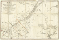
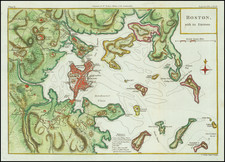
A "Pirated Dublin" Sea Chart of the Northeast Coastline of North America.
A rare chart of the coastline adapted from the work of Cyprian Southack and Mount & Page and published in a Dublin edition of the English Pilot. The Fourth Book.
The chart depicts the northeast coastline and nearby waters from Nova Scotia to the Chesapeake. Designed for use at sea, it provides considerable information on soundings, banks and shoals, and other navigational hazards. All the major coastal features are present, though some in surprisingly distorted form.
While previously believed to have been issued in 1747, a unique copy of the complete pilot in the Boston Athenaeum suggests that this chart was first issued in a 1730 Dublin edition of The English Pilot. The Fourth Book published by George Grierson. Grierson in turn, copied a chart issued by Samuel Thornton in 1706. The present example was issued in the 1767 reissue of the Dublin printing by Grierson's son Boulter Grierson.
George Grierson (c.1678 - 1753)
Scottish born George Grierson was one of the most important publishers, editors and mapmakers in 18th-century Ireland. Dublin was then one of the most important cities in the British Empire, being a bustling port and a financial and services center. Its publishing sector remained underdeveloped however, hampered by ongoing political instability, a relatively strict regime of official censorship, and the overwhelming market dominance of London printers. Particularly with respect to cartographic printing, Dublin’s footprint was miniscule, and even most surveys of Ireland being printed in England. Grierson stepped into the void and more than any other figure transformed Dublin into major printing hub.
Much misinformation has been written about Grierson, and one easily gains the erroneous impression that he was some sort of disreputable fly-by-night journeyman printer subsisting on the piracy of others’ intellectual property. In reality, he was an innovative entrepreneur, the leading publisher in Ireland, and a respected member of the Dublin upper class. While he printed works originated by others, he always did this within copyright laws and always with attribution. In this sense, he was no different than any map maker who issued his own edition of a map previously published (a common and well-accepted practice).
Grierson started out printing Bibles and other religious texts, but eventually moved into printing classics and literature. He produced important editions of Milton's Paradise Lost and Jonathan Swift's Gulliver's Travels. His series of affordable pocket-sized books, Grierson's Classics, were bestsellers of the era.
Grierson died in 1753, but his printing business was continued, first by his eldest son George, who died in 1755 and was succeeded by his younger brother Boulter (d. 1771). Boulter reissued the English Pilot in 1767, with no changes to the plates, a copy of which supplied the chart of New England offered here.
Rarity
All Grierson charts are rare, the present one particularly so: We locate no record of another example having appeared on the market, though the firm of Arkway offered a copy of the full atlas for $58,000 in 2002.
Co-owned with Boston Rare Maps.