This item has been sold, but you can enter your email address to be notified if another example becomes available.


|
||

|

|
|

|
Stock# 55102
Description
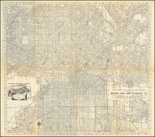
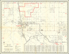
Centered on Watts, with Port Los Angeles North of Santa Monica!
Fine birdseye view style transit map, showing the Los Angeles Basin, with a detailed early map of Los Angeles on the verso.
One of hte more curious features is the location of "Port Los Angeles" north of Santa Monica!
Primary Rail lines include:
- Southern Pacific RR
- Santa Fe RR
- Pacific Electric RR
- L.A. Pacific RR
- LA Interurban RR
The map extends south to Newport and Huntington Beach, east to Chino, Pomona and Lordsburg and North to Burbank, Verdugo, Altadena and Monrovia.
The vignettes showing small trains on the tracks is quite unusual.
Condition Description
Printed on two sides. Some minor tape repairs at fold intersections and one area of thinning, not impacting the view image.