|
||

|

|
|

|
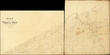
An Eighteenth-Century American Manuscript Town Plan on Vellum: A Robert Morris-Led Land Scheme at Present-Day Rochester, New York.
The earliest-known plan for a town on the future site of Rochester, New York, with an intriguing connection to Robert Morris’ spectacular real estate investments in western New York State.
The map was executed by Charles de Krafft, an eighteenth-century American draughtsman and surveyor whose career included the creation of at least 4 manuscript Revolutionary War Battle Plans, served as one of the primary draftsmen for Pierre L'Enfant during the 1791 planning of Washington, D.C. and drafted a manuscript map of a part of the Ohio Valley for Thomas Jefferson, which Jefferson used to extra illustrate his personal copy of his Notes on the State of Virginia (See the biography section below for a full treatment of de Krafft's life and work.)
The Plan
The plan is skillfully executed in ink and wash color on a single large sheet of vellum. The quality of the work and the use of a large vellum sheet for the creation of the plan strongly suggests that it was made by de Krafft for one of the proprietors most likely Robert Morris.
The proposed town is shown in unparalleled detail, with plots delineated and assigned to the members of the investing syndicate: Robert Morris, Benjamin Barton, Samuel Ogden and Samuel Street. 193 plots are delineated all of which are faintly numbered in a different hand and with a lighter and redder ink than the rest of the map. The plots in Athens are numbered 1-104; in the town at the south end of "Gerundigut" Bay they are numbered 1-38; in the rest of the township they are numbered 1-51. In Athens proper, streets are named with widths noted, and a 15-acre public square is shown at the center of the projected town. The falls are labeled "Great Falls" (some 90 feet high!) and "Little Falls” (these falls offer an enormous potential source of power, largely explaining the appeal of the site as a setting for a major town). The trees used by the surveyor as landmarks are identified in the corners of the township.
The plan was based on a survey made, probably in 1792, by one Captain Job Gilbert, who had an ownership interest in Township 13, just east of Athens. (See Collections and Researches Made by the Michigan Pioneer and Historical Society, p. 488). Gilbert’s work was copied, likely shortly thereafter, by Charles de Krafft.
It is worth noting we have found mention of an untraced 1792 map of Township 14, Range 17 [sic] recorded in a photostat copy at the Rochester Public Library. We have so far been unable to locate this photostat (Blake McKelvey, Rochester History).
Robert Morris and the Athens Scheme
Among the biggest losers of the American Revolution were the Iroquois of central and western New York, most of whom had sided with the British in the hope of forestalling settlement on their lands. The ironic result was that after the war these lands became fair game for wealthy speculators—both American and European—eager to make a killing from sales to land-hungry New England farmers. By means of a maze of treaties and private deals, the region was carved up into enormous tracts, one of which was the so-called Phelps and Gorham Purchase of 1788. The Purchase totaled some six million acres, but for our purposes, the relevant parcel was a huge parcel just east of the Genesee River and another much smaller one—the “Millyard Tract”—to the west of the Falls.
When Gorham and Phelps ran into financial difficulties, they sold the land to Philadelphian Robert Morris in 1791 (1734 – 1806). Morris was a financier, merchant, signer of the Declaration of Independence, and one of the founders of the American financial system. At the time this map was made, he was the United States’ wealthiest citizen and most prolific land speculator, though within a few years the Panic of 1796-97 led to his bankruptcy and imprisonment. At any rate, in the early 1790s he was still flying high, and he soon flipped the parcel—at a huge profit—to a group of British investors known as the Pulteney Association.
However, Morris seems to have retained (or purchased separately) the township of Athens, bounded to the north by Lake Ontario, east by Irondequoit Bay, and west by the Genesee River (the township is shown on Augustus Porter’s very rare A Map of Messrs. Gorham and Phelp's Purchase (1794)). With a small group of investors, he sought to develop a commercial town at the Falls of the Genesee, which with their great height provided a vast source of potential power, along with relatively easy access to Lake Ontario. His fellow investors included Samuel Ogden (1746-1810), who had served as a colonel in the New Jersey Militia during the Revolutionary War. Ogden later became involved in the iron business and served as one of Morris’s agents. Other investors were Benjamin Barton Sr., a New Jersey-based entrepreneur, and Samuel Street, a New England-born trader. Street was one of the most important early American residents on Lake Ontario; he was trusted by the Five Nations and engaged by them to represent their interests to the Federal government.
A 1939 Rochester History article by Blake McKelvey titled "Indian Allen's Mills" provides the best overview of the Athens scheme:
There was a far-flung land-development scheme back of this transaction. Barton was associated with other speculators, including Robert Morris and his agent, Samuel Ogden, in the purchase during 1792 of the township lying between the Genesee River and Irondequoit Bay, now largely occupied by the eastern half of the city of Rochester. There Morris and his associates planned to establish a town at the head of Irondequoit Bay, and a commercial city, to be named Athens, on the east bank of the Genesee at the lower falls. It was obviously necessary to check any rival enterprise at the Allan mill site. The One-Hundred-Acre Tract was therefore acquired by Barton, and its title was shortly turned over to Ogden, the active agent for the associated speculators. But Robert Morris’s land speculations had become so vast that, when in 1793 bank failures in London constricted his credit, it became necessary to unload as much of his property as possible. Thus Charles Williamson was able in 1794 to acquire the Genesee Mill Lot for the Pulteney Estate.
The scheme to develop Township 14 goes to one of the enduring questions about the involvement of Morris and other American investors in western New York: were they interested in actually developing the land they purchased, or were they simply flipping it in Europe for quick profit (namely to the Pulteney syndicate and the predecessors of the Holland Land Company)? This map suggests that the investors were genuinely interested in developing the choicer areas, even if their plans did not come to fruition.
The investment scheme at Township 14 was so short-lived that scant evidence of it remains today. Indeed, it is unclear who took ownership of the land after the original syndicate, although the Pulteney Association probably did so as, or just before, Morris's investments started to go downhill in 1794. What is known is that the Athens scheme was the first formal attempt to found a town on the current site of Rochester, New York and the present map is the most detailed extant record of that attempt. With the real estate frenzy of the 1790s more than a decade in the past, the site was finally built on in 1811 by Colonel Rochester and his partners. With the opening of the Erie Canal in 1825, the city blossomed into one of America's first boom towns.
In the national context, the Phelps and Gorham Purchase was one of a few public-private deals that characterized the first wave of westward expansion in the newly-minted United States. West of the Appalachian Mountains, the Ohio Company of Associates led settlement in what would become Ohio; in the south, the Yahoo land fraud involved a corrupted version of the modus operandi established in the north. Thus, this map of Robert Morris's Athens Scheme represents one of the earliest unique artifacts of American westward expansionism that one might hope to obtain.
Charles de Krafft was born Johann Carl Phillip von Krafft and is also known as John Charles Phillip von Krafft.
Overview
De Krafft led a remarkable life. He arrived in America in 1778 as a trained Prussian Military Officer, who had spent the prior two years as a mercenary and privateer. After failing to gain a commission at Valley Forge from George Washington, he joined the British in Philadelphia, receiving a commission in a Hessian Unit led by George Hanger. During this time, he credated a number of excellent manuscript battle plans.
Following the war, de Krafft returned to America, joining his wife and young son in New York City in 1784. He would obtain a position as a surveyor, which took him to Philadelphia and the Washington DC area by 1789, where he was known to have worked on at least one manuscript survey by John Hills. De Krafft is also known to have worked with Reading Howell in Philadelphia (The Independent Gazette, March 31, 1792).
De Krafft's most important post-War engagement was as one of the primary assistants of Pierre L'Infant in the original survey and mapping of the District of Columbia. Following L'Infant's dismissal, de Krafft stayed on and worked with Andrew Ellicott on the completion of the survey of Washington and the District of Columbia.
In this same time frame, he prepared original surveys and made copies of other surveys for Thomas Jefferson, the Penn Family and Robert Morris.
From about 1796 to 1800, de Krafft served with Andrew Ellicott during the survey of the line between Spanish West Florida and Mississippi Territory, following the signing of the Pinckney Treaty with Spain in October 1795.
De Krafft settled in Washington, DC, working as as surveyor and draughtsman. His son would go on to become one of the first City Surveyors of Washington, DC. Toward the end of his life, in 1804, De Krafft was visited by Alexander Von Humboldt, a family friend, during Humboldt's 2 week stay in Washington D.C. enroute back to Europe from Mexico. De Krafft was quite likely present when Humboldt briefed Jefferson and others on the cartographic and other information about Northwestern New Spain during his time in Mexico.
Biography
Johann Karl Philip von Krafft (1752–1804) was born in Dresden to a career military family. Krafft was commissioned an ensign in 1773 in the Prussian army under Frederick the Great. He resigned his commission in 1776, desiring greater adventure in another army. Between 1776 and 1778 he travelled to Russia, Denmark and Quebec unsuccessfully seeking a new officer's commission with a brief service as an American privateer.
Von Krafft attempted to secure a commission from George Washington in the Continental Army at Valley Forge in early 1778, but when he could not obtain an appointment as an officer, he crossed the lines into British-occupied Philadelphia and joined one of the German regiments fighting for the British. Krafft saw action at Monmouth and spent the remainder of the war with Henry Clinton's Army at New York.
At the close of the war, Krafft married Miss Cornelia de la Metre in New York. After returning with the British Army to England in 1783, he returned to America the following year where he supported his family in New York as a teacher. He then obtained a position as a surveyor and draftsman for the United States Treasury Department, a position he held until his death.
In a letter written by Baron von Steuben to Lachlan McIntosh sold at RR Auction on December 15, 2012 (Lot #1032), Van Steuben writes, in full,
New York . June 1st 1784
This will be delivered you by Mr de Kraft [J. C. von Krafft] a Gentleman of an exceeding good family in Saxony who came over to this Country in the Services of the Prince of Hesse—but marrying in this place a Girl of no fortune and being on that account deserted by his Parents he has returned to this Country with the View if possible to establish himself[.] Mr de Kraft has had a good education, is well acquainted with the Military Mathematics and is an excellent Draughtsman he has some knowledge also of Civil Architectures—If in the business of Surveying land—as an engineer—or as any other line he can find employ for his talents I have no doubt he will render himself both useful and agreeable—Permit me my dear Sir to solicit your protection for him in Georgia, he wishes to establish himself in that state and if you can in any matter second his Views or afford him any assistance, I shall be such obliged to you.
The Magazine of American History (1888) volume 19 (pages 183-84) gives a precis of his biography in a review of his Revolutionary War journal, which was published by the New York Historical Society:
Von Kraft was born in Dresden, Saxony, in 1752, and is said to have belonged to a baronial family; he was related to many persons of rank in Prussia and Saxony. At twenty-one he was commissioned ensign in General von Luck's regiment of fusiliers in the Prussian army under Frederick the Great, and was promoted the same year. In seeking advancement three years later he resigned his commission, and after visiting Russia and wandering over Europe, he sailed for America, where he served in the Revolutionary War under Von Donop, and later on under Von Bose. He married in New York, and after the government was established under the Constitution, was employed as surveyor and draughtsman to the Treasury Department. In connection with his journal he made several maps and sketches…notably the plan of the battle of Trenton, with explanations, the battle-ground at Monmouth, the plan of Red Bank fort, in New Jersey, the plan of the region between Philadelphia and Valley Forge, with the several positions occupied by the British and the Americans, a sketch of New London and Groton-town, and the plan of the military positions on Manhattan Island, all of which are of exceptional historic interest and value.
On the 4th of January, 1780, Von Kraft writes: “On men-guarde in Wall street.” In the same connection he records as follows: “The cold was so intense this winter that the inhabitants could not remember the like for twenty years back. The North River was wholly frozen over, and the East River had an astonishing quantity of floating ice. As, in spite of this, many people ventured out in boats, sad accidents happened almost daily. The wood magazines were emptied, and as we could not get our wood from Long Island on account of the ice, old ships were assigned to all the English and Hessian regiments for firewood. Even then we had only half allowance and the other half was to be paid to us. The Rebels had now the best opportunity to attack us from all sides to the best advantage. We expected it hourly, and therefore the best measures were taken.”
As a mapmaker, De Krafft had an exceptionally diverse output; he is recorded as the author of a descriptive watercolor of the Spruce Street Jewish Cemetery in Philadelphia, "showing plan of burial ground"; he is credited as the compiler for Osgood Carleton's “Plan of Part of the District of Maine” (1793); he drew a manuscript map of the Native American mound fortifications which was bound into Thomas Jefferson's own copy of Notes of Virginia; and most importantly, he worked with Pierre L'Enfant to lay out Washington, D.C. in 1791. Pamela Scott writes, in Capital Engineers (2012):
The Georgetown Weekly Ledger of July 2, 1791, reported that “a large number of gentlemen attending, a plan of the city, which had for several weeks occupied the time and talents of Colonel L’Enfant, assisted by the Baron de Graff, and which, with some small alterations [Washington] had determined to adopt” was shown to the public. Scholars have long speculated who “Baron de Graff” was. In 1800 “Charles de Krafft, Surveyor and Draftsman” advertised in a local newspaper that he “was employed by [the] government in the year 1791 (at Georgetown) to assist Major L’Enfant to plan and lay down the first draft, for the city of Washington.”
In the Biographical Sketch written by Thomas Edsall in 1887 which accompamies the published version of de Krafft's Revolutionay War Journal, Edsall writes:'
A few months before Krafft's death, Baron von Humboldt, who had known him and his family in Germany, spent several days on a visit to Krafft, at his home in Georgetown. Humboldt informed him of the death of his mother, with whom he had ceased to correspond for many years, and advised him to return to Germany and lay claim to his estate, which was in the possession of a venerable maiden relative. He had made his preparations to do so, when he was seized with an attack of congestion of the lungs, which terminated his life, July 24, 1804. Mr. de Krafft was a man of commanding presence and of courtly and fascinating manners. He had a quick temper, and was sensitive to affronts. During his military service— 1770 to 1784— he was the principal in some twenty duels, and was several times severely wounded. His descendants have held responsible positions and high rank in the civil service and naval service of the United States.