|
||

|

|
|

|
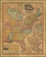
Hand Drawn Map of the United States Locating Companies Involved in the 1794 Yazoo Land Fraud -- Possibly Drawn in the Southern United States.
Remarkable large manuscript map of the United States drawn on Whatman paper (unfortunately with the dating cut off), showing unsual early details relating to the Yazoo Land Fraud. Based upon a detailed study of the map, we believe that it derives in part from the details shown in the Arrowsmith & Lewis map of Mississippi Territory, published in 1804.
In the west, St. Louis is named and an excellent accounting of the Missouri River is given and a "Gold Mine" is shown west of the White River on the Arkansas River (a detail shown on Arrowsmith's 1802 4 sheet Map of the United States, but not the 1802 Map of the Interior Parts of North America).
The dating of the map is a bit complicated, but would seem to include the following clues:
- Michigan Territory is named -- created June 30, 1805
- Indiana Territory is named -- created July 4, 1800
- Early version of Mississippi Territory shown -- terminated April 24, 1802
- Yazoo Lands Shown -- see below
The map shows Mississippi Territory (consisting of the southern parts of the modern states of Alabama and Mississippi in a darker blue) during the time period between its organization as a Territory in April 7, 1798, and the annexation of regions to the north (the so-called Yazoo Lands), (in lighter blue) in April 24, 1802 (between 35th parallel and 31st parallel of latitude west to Mississippi River, across present-day Alabama and Mississippi).
West of Georgia and north of Mississippi Territory, the area south of Tennessee includes the names Upper Mississippi Company and Georgia Company. These two names related to the so called 1794 Yazoo Land Fraud.
Yazoo Land Fraud -- Upper Mississippi Company and Georgia Company
The State of Georgia originally claimed its western boundary extended to the Mississippi River. In 1789, three companies, the South Carolina Yazoo Company, the Virginia Yazoo Company, and the Tennessee Company formed to buy 25,000,000 acres of land from the Georgia General Assembly. The land sale fell through when the legislature insisted on payment in gold or silver specie rather than depreciated paper currency.
In 1794, the General Assembly agreed to consider proposals for sale of the western lands to private companies. Four Yazoo companies, the Georgia Company, the Georgia-Mississippi Company (formerly the South Carolina Yazoo Company), the Upper Mississippi Company (formerly the Virginia Yazoo Company), and the Tennessee Company pushed through a bid of $500,000 for 35,000,000 acres in present-day Alabama and Mississippi. Major stockholders in the company included two United States senators, two congressmen, three judges, a territorial governor, and a United States attorney. It was alleged that U.S. Sen. James Gunn arranged bribes of money and land to legislators, state officials, newspaper editors, and others to secure the bill's passage despite angry and vociferous public opposition. Of the legislators who voted for the bill, all but one was a shareholder in one or more of the companies.
U.S. Senator James Jackson, a Jeffersonian Republican, resigned his seat and returned to Georgia to overturn the sale. The bribery charges were substantiated in public hearings and later in 1795 many of the bill's supporters were voted out of office. The bill was rescinded by a reform legislature on February 18, 1796. When Jackson was elected governor in 1798, he orchestrated a revision of the state constitution which incorporated the substance of the Rescinding Act. Jackson succeeded in blocking the cession of the western territories to the United States until the Republicans were in control of the federal government; after Thomas Jefferson's election to the presidency in 1802 Georgia commissioners, including Jackson, transferred the western territory and Yazoo claims to the federal government for $1.25 million.
On February 21, 1796, three days after passage of the Rescinding Act, all records of the bill and resulting sales were burned in front of the State Capitol in Louisville.
But the matter was not over. The state refunded money to persons who had purchased land, but some refused the money, preferring to keep the land. The state did not recognize their claims, and the matter was to wind through courts for the next decade. In 1802, the state ceded to the federal government all claim to lands west of its present border (which were organized into the Mississippi Territory), along with the ongoing legal disputes. Claims by third-party owners who had innocently purchased land from the original companies were not fully resolved until 1816. Spanish claims to the Georgia territory were resolved with the 1795 Treaty of San Lorenzo; Native American claims to the area were extinguished by a series of treaties ending in the 1820s.
Legal challenges to Georgia's attempt to repeal the sale reached the Supreme Court in 1810. The landmark Fletcher v. Peck decision marked one of the first times the Court overturned a state law, deciding that the land sales were binding contracts and could not be retroactively invalidated by the passage of superseding legislation.
Interpreting The Details of in Map
We have been unable to locate a base map from which this map was drawn. Most of these manuscript maps were drawn by American secondary school students in the first part of the 19th Century, typically in New England. However, the attention given to the Yazoo Land Fraud and extra emphasis on cartographic details in the South and the West. Specifically, there are virtually no interior place names given in New England and the Northeastern States. Even Virginia, Kentucky and North Carolina are relatively devoid of interior place names.
By contrast, the number of interior place names and details is substantial in South Carolina, Georgia, Mississippi Territory, West Florida, and Tennessee. There are also significant details given in Ohio, Indiana and the areas west of the Mississippi River. While it is possible that the map is unfinished, the decision to include the Yazoo Land Fraud information in the map suggests that there is a significantly greater prospect that the present map was drawn in the South, most likely by a student in South Carolina or Georgia, where the interest in this ongoing legal battle would have been the highest.
If so, this would be a rare example of "school girl" map drawn in the southern part of the United States.
![(Coast of Florida, Georgia and the Carolinas] [To The Members Of The Nautical Institution And Ship-Masters' Society Of The City Of New York, This Chart, Extending From Lat. 40°15 N., Long. 72°15 W., to Lat. 22°35 N., Long. 80°25 W., Is Respectfully Dedicated / By Their Obedient Servant Edmund M. Blunt]](https://storage.googleapis.com/raremaps/img/small/77294.jpg)
![[Hand Drawn School Girl Map] United States](https://storage.googleapis.com/raremaps/img/small/67904.jpg)
![[An English Propaganda Map In French] Carte Des Possessions Angloises & Francoises Du Continent De L'Amerique Septentrionale 1755.](https://storage.googleapis.com/raremaps/img/small/86975.jpg)