


|
||

|

|
|

|
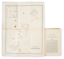
Rare Separately Issued Example of the Entrecasteaux-eautemps-Beaupre Chart of Australia, New Zealand, etc.
Remarkable sea chart of Australia, New Zealand and contiguous regions, extending to Borneo, Mindanao and the Straits of Malacca.
Unlike most examples of the chart, this example was separately issued by the French Depot de la Marine, bearing the number "Hyd. Fr. No. 588" and a price "Prix. 1F. 50c"
The chart is drawn from a sea chart originally compiled specifically for the expedition of Antoine Raymond Joseph de Bruni d'Entrecasteaux in search of the La Perouse expedition, which had left Botany Bay in March of 1788 and had not been heard from since. Entrecasteaux was a French naval officer, explorer and colonial governor. He is perhaps best known for his exploration of the Australian coast in 1792, while searching for the La Pérouse expedition.
Among the more fascinating elements of the printed chart are the means by which it distinguishes between surveyed coastlines in Australia and New Zealand, conjectural coastlines and that which was then completely unknown.
The chart depicts the tracks of the French ships through the region in 1791 to 1793 with meticulous detail.
The original manuscript map from which this map was drawn was sold on November 29, 2004 (Lot 49) by Sothebys for 141,500 AUD. The description below is drawn from the Sotheby's catalog:
AN IMPORTANT MANUSCRIPT MAP, ENTITLED IN THE CARTOUCHE: 'CARTE RÉDUITE de la NOUVELLE HOLLANDE et des ARCHIPELS Situés au Nord et à l'est de cette Ile sur la quelle on a marqué les Découvertes et Reconnoissances faittes en 1792 et 1793 Par le Contre Amiral D'Entrecasteaux, Commandt des frégattes Françaises envoyées à la Recherche de M. de la Pérouse. Redigée au Cap de Bonne Espérance Par Beautemps Beaupré, Ingenieur hydrographe, en 1796.
Large original manuscript map, approx. 640 by 880 mm, pen and coloured wash over pencil on paper with pencil annotations, bearing watermark 'D & C Plauw, IV' [i.e., Revolutionary Calendar 1796]; titled in the cartouche. The whole map dissected and laid down on silk, in excellent condition with a few minor tears at folds and pin marks at the corners.
A VERY IMPORTANT MANUSCRIPT MAP OF AUSTRALIA, one of few original voyage maps to survive in private hands and one of remarkably few original 18th-century maps of Australia and New Zealand. This map of Australia, New Zealand and neighbouring countries was prepared by the official hydrographer of the d'Entrecasteaux expedition to show the state of knowledge of the area and the new discoveries and is one of the manuscript charts from which the general map was prepared in the published Voyage de Dentrecasteaux. The image it presents of the continent of Australia was to remain basically unchanged until the Baudin and Flinders expeditions. The map shows the route taken by d'Entrecasteaux in blue ink, dated accordingly.
Beautemps-Beaupré drew the map at the Cape of Good Hope on the return voyage with the remaining complement of d'Entrecasteaux's crew. (D'Entrecasteaux had died before the expedition reached Java). During their four-year absence, the French monarchy had been replaced with a republic and France found herself at war with most of the major powers of Europe, including England. Rossel, the new commander of the expedition, had decided to proceed to Holland in the safety (or so he thought) of a Dutch convoy, carrying with him the expedition's papers and charts. The eminent French historian, Hélène Richard, has described the events that led to the drawing of this chart:
'Beautemps-Beaupré left the Dutch fleet at the Cape of Good Hope at the same time as Renard (the surgeon). The hydrographer was charged by Rossel with keeping a duplicate of all the charts of the voyage and he took advantage of the long stop which he made in South Africa to put in order the greater part of his charts and to draw up the general map of the voyage? marking on it the route of the frigate (80). He learnt during his stay at the Cape of the capture by an English squadron and then "the sinking of a Dutch vessel the Hougly, on board which was Lt Rossel with all the effects of the expedition to find La Pérouse" (81). He wanted to take all the precautions necessary to assure the return to France of "the essential part of this expedition" (82), of which he found himself he thought, now the only holder from shipwreck of the documents carried by Rossel. So he made a new copy of his maps and entrusted them to surgeon Renard who made his way to France by way of America. He thought that in this way one copy would be saved if he himself met with a mishap on his return (83). For his part, the hydrographer returned home via Sweden in a vessel of the Compagnie de Chine which left the Cape on 18 April 1796. He disembarked at Gothenberg on 7 June and reached France only with the aid of the French Vice-Consul in that city, who advanced him the funds to make the journey, for he was penniless. On his return to Paris, he placed with Admiral Truguet, Ministre de la Marine, the series of sixty-four maps which he had kept with him and which were before long joined by those carried by Renard.'
(Translated from the French text.) (References)
80. Paris. Archives Nationales (A.N.) Mar. 6JJ3 Pièce 11A. Cette carte est daté du Cap de Bonne Esperance, 1796.
81. A.N. Mar. C7 284. Dossier Rossel. Pièce 6. Lettre de Beautemps-Beaupré à l'ambassadeur de France aux Etats-Unis d'Amerique. Le Cap. 1796, 15 Avril.
82. ibid.
83. ibid., Pièce 5, Reçu du Renard, daté du Cap. le 15 Avril 1796.That this map is the specific document prepared at the Cape by the hydrographer and taken to France by his colleague Renard is attested by the final manuscript note, that 'Cette Carte dôit être jointe au journal de M. Renard Chirurgien Major de la Recherche, et déposée avec lui dans les Bureaux de la Marine'.
As it happened, Rossel's papers also survived, since the British had transferred them out of the Hougly before it sank, but as a monarchist, Rossel remained a willing captive in England until June 1802 (two years after Labillardière had published his account of the voyage, and Baudin had already departed on his voyage). On his return to France, Fleurieu arranged for the publication of the official account of d'Entrecasteaux's voyage which finally appeared in 1808.
In summary, Beautemps-Beaupré made three sets of charts. The first went with the expedition's new commander Rossel. He and his charts were captured by the British and were not returned to France until 1802. Beautemps-Beaupré sent the second set to France with the surgeon Renard via America. However, by the time Renard arrived, Beautemps-Beaupré had himself arrived in France with the third set which he deposited in the Ministry of Marine. The manuscript chart offered here is from the second set which Renard carried and which had presumably been made redundant by Beautemps-Beaupré's arrival.
The manuscript chart also shows an additional pencilling of the route of Baudin's voyage (until Tasmania) by an unknown hand. The previously missing coastline of South Australia and Victoria has been correctly drawn in, using the standard cartographical grid method; and there are some notes of geographical details in pencil beneath Timor. Other smaller, more indistinguishable notes are scattered along the West Australian coast, and 'Perte de?' can be deciphered to the west of the island of Borneo. Of especial interest is the use of crimson ink to highlight those places recognised by the d'Entrecasteaux expedition.
The map may be compared with the first in the Atlas of the official 1808 publication of the account of the voyage . . . , the 'Carte Générale de la Nouvelle Hollande et des Archipels du Grand Océan, qui sont au Nord et à l'est de cette terre; dressée, en 1807; pour servir au Voyage du Contre-Amiral Bruny-Dentrecasteaux, fait, Par Ordre du Gouvernement, en 1791, 1792 et 1793; Par C.F. Beautemps-Beaupré, Hydrographe Sous-Chef du Dépôt Général de la Marine.'
Rarity
The chart is rare on the market, especially as a separate publication. We note 1 example from the Atlas at auction in the past 30 years and 1 example in a dealer catalog, both from the atlas.
The Dépôt de la Marine, known more formally as the Dépôt des cartes et plans de la Marine, was the central charting institution of France. The centralization of hydrography in France began in earnest when Jean-Baptiste Colbert became First Minister of France in 1661. Under his watch, the first Royal School of Hydrography began operating, as did the first survey of France’s coasts (1670-1689). In 1680, Colbert consolidated various collections of charts and memoirs into a single assemblage, forming the core of sources for what would become the Dépôt.
The Dépôt itself began as the central deposit of charts for the French Navy. In 1720, the Navy consolidated its collection with those government materials covering the colonies, creating a single large repository of navigation. By 1737, the Dépôt was creating its own original charts and, from 1750, they participated in scientific expeditions to determine the accurate calculation of longitude.
In 1773, the Dépôt received a monopoly over the composition, production, and distribution of navigational materials, solidifying their place as the main producer of geographic knowledge in France. Dépôt-approved charts were distributed to official warehouses in port cities and sold by authorized merchants. The charts were of the highest quality, as many of France’s premier mapmakers worked at the Dépôt in the eighteenth century, including Philippe Bauche, Jacques-Nicolas Bellin, Rigobert Bonne, Jean Nicolas Buache, and Charles-François Beautemps-Beaupré.
The Dépôt continued to operate until 1886, when it became the Naval Hydrographic Service. In 1971, it changed names again, this time to the Naval and Oceanographic Service (SHOM). Although its name has changed, its purpose is largely the same, to provide high quality cartographic and scientific information to the France’s Navy and merchant marine.
![South Pacific Ocean. The New Hebrides, Loyalty, Feejee, and Friendly Islands &c. [and] The Society, Marquesas, and Low Islands &c.](https://storage.googleapis.com/raremaps/img/small/78668.jpg)
![[Sangihe Island and Talaud Islands, Indonesia] Het Eyland Sangir (and) De Talutse Eylanden](https://storage.googleapis.com/raremaps/img/small/74784.jpg)