


|
||

|

|
|

|
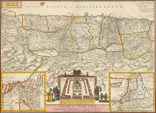
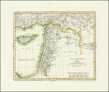
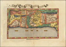
An Early Modern Map of the Holy Land
Finely colored example of Fries's edition of the landmark Sanuto-Vesconte map, the most influential modern map of the Holy Land published 15th Century.
As noted by Nebenzahl, the Sanuto-Vesconte map " was destined to provide the basic image of the Holy Land until the eighteenth century." When first published in 1482 in both the Ulm and Berlinghieri (Florence) editions of Ptolemy, the map was the first printed map of the Holy Land based on modern sources.
Fries map, which is based upon Waldseemuller's interpretation of the map which was first published in 1513, is the first example of this projection which is reasonably obtainable for most collectors. The map was published with small changes to the title and verso in 1522, 1525, 1535 and 1541. The first two editions are very rare on the market, this being the first example we have ever offered.
Pietro Vesconte was an early 14th Century Genoese cartographer and geographer. A pioneer in the field of the portolan charts, he influenced Italian and Catalan mapmaking throughout the fourteenth and fifteenth centuries. He appears to have been the first professional mapmaker to sign and date his works regularly. Vesconte's nautical charts are among the earliest to map the Mediterraean and Black Sea regions accurately. Vesconte provided a world map, nautical atlas, a map of the Holy Land and plan of Acre and Jerusalem for inclusion in Marino Sanuto's Liber secretorum fidelium cruces, a work which aimed to encourage a new crusade. There are three known copies of Sanuto's Liber which that include Vesconte's maps.
Marino Sanuto (c. 1260 - 1338) was a Venetian statesman and geographer, who is best known for his life-long attempts to revive crusades. His Liber secretorum fidelium cruces, also called Historia Hierosolymitana, Liber de expeditione Terrae Sanctae, and Opus Terrae Sanctae, included an extensive discussion of trade and trade-routes, as well as of political and other history and included a number of maps and maps and plans which would become important in the development of cartography 15th and 16th Century cartography. His work was begun in March 1306, and first finished in January 1307, when it was offered to Pope Clement V as a manual for true Crusaders who desired the reconquest of the Holy Land. To this original Liber Secretorum Sanuto it added largely; two other "books" composed between December 1312 and September 1321, when the entire work was presented by the author to Pope John XXII, together with a map of the world, a map of modern Palestine, a chart of the Mediterranean, the Black Sea and west European coasts, and plans of Jerusalem, Antioch and Acre. A copy was also offered to the king of France, to whom Sanuto desired to commit the military and political leadership of the new crusade.
Lorenz (Laurent) Fries (ca. 1485-1532) was born in Mulhouse, Alsace. He studied medicine, apparently spending time at the universities of Pavia, Piacenza, Montpellier and Vienna. After completing his education, Fries worked as a physician in several places before settling in Strasbourg in about 1519. While in Strasbourg, Fries met the Strasbourg printer and publisher Johann Grüninger, an associate of the St. Dié group of scholars formed by, among others, Walter Lud, Matthias Ringmann and Martin Waldseemüller.
From 1520 to 1525, Fries worked with Grüninger as a cartographic editor, exploiting the corpus of material that Waldseemüller had created. Fries' first venture into mapmaking was in 1520, when he executed a reduction of Martin Waldseemüller's wall map of the world, first published in 1507. While it would appear that Fries was the editor of the map, credit is actually given in the title to Peter Apian. The map, Tipus Orbis Universalis Iuxta Ptolomei Cosmographi Traditionem Et Americ Vespucii Aliorque Lustrationes A Petro Apiano Leysnico Elucubrat. An.o Dni MDXX, was issued in Caius Julius Solinus' Enarrationes, edited by Camers, and published in Vienna in 1520.
Fries’ next project was a new edition of the Geographia of Claudius Ptolemy, which was published by Johann Grüninger in 1522. Fries evidently edited the maps, in most cases simply producing a reduction of the equivalent map from Waldseemüller's 1513 edition of the Geographie Opus Novissima, printed by Johann Schott. Fries also prepared three new maps for the Geographia, of Southeast Asia and the East Indies, China, and the world, but the geography of these derives from Waldseemüller's world map of 1507.
The 1522 edition of Fries' work is very rare, suggesting that the work was not commercially successful. In 1525, an improved edition was issued, with a re-edit of the text by Willibald Pirkheimer, from the notes of Regiomontanus (Johannes Müller von Königsberg).
After Grüninger's death in ca. 1531, the business was continued by his son Christoph, who seems to have sold the materials for the Ptolemy to two Lyon publishers, the brothers Melchior and Gaspar Trechsel, who published a joint edition in 1535, before Gaspar Trechsel published an edition in his own right in 1541.