


|
||

|

|
|

|
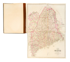
Unique Stencil Color Example of Morse & Breese's Cerographic Atlas of the United States, bound with Morse's Cerographic Bible Atlas.
The Cerographic Atlas of the United States was the first printed atlas to employ the use of cerography, a printing process invented by Sidney Morse.
The present example contains 38 maps, one more than usual for the two books.
Rumsey notes:
The first Cerographic Atlas of the United States. Issued in three parts (although Woodward states that it cannot be determined how many parts were issued . . .) . . . The maps are printed on both sides of a sheet and are uncolored. This was issued as a supplement to the New York Observer in 1842, 1843, and 1845. In 1845 it was republished as Morse's North American Atlas, with some changes to the maps and the addition of color. . . . When complete, this edition has 32 maps, four less than the 1845 edition, but including a map of Oregon and a map of Iowa not found in the 1845 edition.
The Maine map in this edition is very different from the 1845 edition because it does not show the boundaries of the treaty of 1842; the separate map of Iowa, showing the early formation of eastern counties, is not present in the later edition which has only the map of Iowa and Wisconsin. The Oregon map is derived from Wilkes' Map of the Oregon Territory (almost a copy, actually). . . . According to Ristow, the Map of Connecticut originally appeared in the June 29, 1839 issue of the New York Observer, as an example of the Cerographic process, along with Morse's announcement that additional maps would be published to form an atlas.
The present example is noteworthy as the only example we have ever seen with stenciled color. Because of the quality of the color and includes the set of biblical maps, it is possible that this copy was a publisher's proof or some sort of sample copy, almost certainly pre-dating the issuance of the North American Atlas.
Some of the more important maps contained in the atlas include:
- T.J. Farnham's Map of The Californias
- Josiah Gregg's Map of The Indian Territory Northern Texas and New Mexico
- J.N. Nicollet Map of Iowa and Wisconsin
- Republic of Texas
- Map of Oregon Territory
- Two Maps of New York City area
![Atlas Nouveau, Contenant Toutes Les Parties du Monde, Ou sont exactement Remarquees les Empires, Monarchies, Royaumes, Etats, Republiques &c. [New Atlas, Containing All the Parts of the World, Where Exactly Remarked are the Empires, Monarchies, Kingdom, States, Republics, &c.]](https://storage.googleapis.com/raremaps/img/small/71061.jpg)
![[ Hand Drawn by Hastings Crossley ] Atlas of Modern Geography (Inscribed to Miss Frances Irwin From Hastings Crossley)](https://storage.googleapis.com/raremaps/img/small/101470.jpg)
![[ World Atlas ] L'Europe en Plusieurs Cartes Nouvelles et Exactes [bound with] L'Asie en Plusieurs Cartes Nouvelles et Exactes [and] L'Afrique en Plusieurs Cartes Nouvelles et Exactses [and] L'Amerique en Plusieurs Nouvelles et Exactes](https://storage.googleapis.com/raremaps/img/small/95822.jpg)