|
||

|

|
|

|
Rare French & Indian War Wall Map of North America
Fascinating map of North America, published posthumously by Mary Ann Rocque (wife of the late John Rocque) and Andrew Dury.
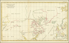
Rocque's map of North America is perhaps the single most accurate map of the whole of the continent to date, including much original western information not found on any other printed map. The map includes the recent Spanish, French and English discoveries in the West and Northwest, with numerous historical and geographical notes including speculation as to the source of the Missouri River.
The map is extensively annotated with information on Indian Treaties in North America and other bits of historical information about the British Colonies, including Drake's landfall in 1579 near San Francisco, where he took possession of the region for Queen Elizabeth "on a free surrender of possession by the natives . . . "and a wonderful note on Bermuda, "If a terrestrial paradise is supposed, Bermuda claims it; no part of the world enjoys a pure Air, or more temperate Climate &c. is remarkable for Health, delicate Provisions, &c. they build swift sailing Vessels which they Sell to the Sugar Islands. They are dexterous in the recovery of Wrecks."
A large undefined 'West Sea' is placed in the northwest and a note that it is very uncertain whether the region is land or sea. The map is relatively restrained in its depiction of cartographic myths, although speculative notes are shown for several rivers west of the Great Lakes, including Assinipoels R(iver), "which its (sic) thought goes into the west sea."
The map includes a number of early roads, including roads reaching the Taos, New Mexico area, and early road to Texas and throughout the Southern British Colonies.
Fort Orleans (established in 1723) on the Missouri River is shown, one of the earliest European Forts west of the Mississippi River in what would become the future United States.
The map depicts a radically different, and more informative cartography than the current French (i.e. D'Anville) cartography west of the Mississippi. Pikes Lake (unnamed) and Manton's River in the northwest are precursors of the River of the West, which would extend westwards out of the lake. These first two features appear to have been first seen on Nicolas Bellin's map of North America, 1755, following the manuscript of Verendrye. It is believed this is the first appearance of this information on an English map. Its cartography differs in the west from the Mitchell map of 1755, particularly in the Upper Mississippi River depiction. The source of the Rio Grande is marked as unknown.
Wheat notes that the map is an interesting map for the Mississippi Valley and the country to the west, especially good for what is now Arizona, showing all the villages named for the Apostles on Rio des Apostres (the Gila River). Fort St. John is shown in Texas on the Rio Grande, as is the road through Texas to Mexico. Another fascinating note describes Santa Fe and New Mexico.
The boundaries of New England and Virginia by various early 17th Century charters extending to the West Coast are noted, with the boundaries plotted from the Atlantic to the Pacifica.
Many other fascinating annotations are included in the map.
Rarity
The map is rare on the market. We note no examples at auction since the Streeter Sale (1969, Lot 3911).
John Rocque (circa 1704-1762), an 18th-century surveyor of Huguenot descent, left a profound imprint on the topographical representation of England, particularly through his elaborate maps of London and its surroundings. Despite his significant contributions, his life, both personally and professionally, remains somewhat cloaked in mystery.
Born likely around 1704 or 1705 to French Huguenot parents who migrated to Geneva following the revocation of the Edict of Nantes, Rocque found his calling in England. There, he and his siblings were known to have spent significant parts of their lives. His journey into surveying took off in 1734, with his first recognized work involving a survey of Richmond House and its gardens. This engagement emerged at a fortuitous time when the landscaping and design of the nobility's estates were witnessing renewed interest, which required accurate surveying—a skill Rocque exemplified.
Rocque didn't confine his talents to surveying alone but ventured into printselling, owning a shop near Hyde Park Corner by 1743. This enterprise reflected his energetic nature and the breadth of his ambition, contributing to his reputation for high-quality work, evidenced by the size of his workforce, which included up to ten draughtsmen and engravers at times.
In his later years, Rocque faced adversity, with his shop and entire stock in Whitehall being devastated by fire in 1750. However, his resilience saw him bounce back, and despite several relocations, Rocque maintained his business operations around the Strand area. By the 1750s, his work had taken him to Dublin, where he made substantial contributions in the form of numerous Irish maps and various English county maps.
On the personal front, Rocque married twice but had no known children from either marriage. His first wife was Marthe, whom he married by 1728, and following her death, he married Mary Anne Bew in 1751. Rocque's health began deteriorating towards the end of his life, leading to his death on January 27, 1762. His widow, Mary Anne, continued to manage the business for several years after his demise.
![[First State of the Popple Key Sheet] A Map of the British Empire in America with the French and Spanish Settlements adjacent thereto by Hen. Popple.](https://storage.googleapis.com/raremaps/img/small/92714.jpg)