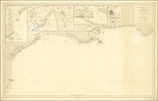


|
||

|

|
|

|
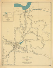
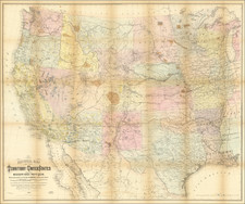
Rare Early State With Manuscript Additions Showing Indian Reservations
An unusual and perhaps unique example of Keeler's "National Map", one of the most influential maps of the American West published immediately following the conclusion of the Civil War.
The present example of the map was apparently an early proof copy, pre-dating the addition of the Indian Resevations in and before 1867, but continuously updated to include treaties in late 1867 and 1868 not referenced in the normal Keeler map of 1867, nor incorporated in his 1868 maps. Almost certainly, this was some sort of an official copy map.
First, a number of the Indian Reservations which existed in or before 1867 and which appear in printed format on most examples of this map are not present in printed form, but instead have been hand written in by a contemporary hand. Some examples include:
- Yakama Reserve
- Grand Ronde (Oregon)
- Silitz Res. (Oregon -- spelled Salitz on the later printed versions)
- Warm Springs Res. (Oregon -- with no printed border--the later edition includes a printed border).
- Klamath Res. (Oregon - Shown and colored, but not named in the later version).
- Smith River Res. (California -- shown and colored, but not named in the later version)
- Klamath Riv. Res. (California)
- Hoppa Valley Res (California)
- Mendocino Res.
- Round Valley Res. (California)
- Nome Lackee Res (California)
- Makah Res. (Washington)
- Swanomish Res. (Washington)
- Snohomish Res.
- Duamish & Suquamish Res. (Washington).
- Skokomish & Selallam Res (Skokomish & Sklallam on the earlier map).
- Nisqually Res.
- Puyallup Res.
- Upper Yakama Res.
- Umatilla Res (colored on the earlier example, but not named).
- Bois Forte Chipps. (Minnesota)
- Sisseton & Warpeton Sioux Yanctonnais Sioux Cuthead Band (North Dakota)
- Unnamed Reservation near Pigeon River and Lake Superior (Minnesota)
- The Winnebago Resrvation on the Missouri River appears only on the east side, whereas it appears on both sides on the later edition.
- The Yankton Reservation on the Missouri River appears only on the north side of the river, whereas it appears on both sides on the later edition.
- Candian District (south of Ft. Gibson (Indian Territory)
- Osage Trust Lands (SE Kansas, west of the Arkansas River)
Second, for Resevations created after 1867, the region is highlighted in red and includes dating and details in manuscript:
- Proposed Reservation for Gros Ventre, Piegan, Blood, Blackfeet & River Crow Inds. Treaty 1868
- Reservation set apart for Different Tribes of Sioux Indians Treaty April 29, 1868 Proclaimed February 24, 1869
- Reservation for the Tabeguache Muache Capote Weeminuche Yampa Grand River Uintah Bands of the Ute Indians Treaty March 2, 1868. Proclaimed Nove 6, 1868.
- Reservation for the Navajo Indians Treaty June 1, 1868, Proclaimed August 12, 1868.
- Reservation for Arapahoes & Cheyennes Treatly Oct. 28 1867.
- Reservation for Kiowa, Comanche Apache Indians Treaty Oct. 21, 1867, Proclaimed Aug. 25, 1868
- Reservation for the Osage Ind. Treaty May 27, 1867
- Canadian District
There is also a section indicationg Land Ceded to the US
- Ceded to the U.S. by the Choctaws and Chick asaw April 28, 1866
- Choctaw & Chickasaw Cession between Middle and North Fork of the Red River
The map provides a monumental compilation of data from many governmental sources and is color coded to show the locations of Gold, Silver, Copper, Quicksilver, Iron and Coal. Completed and proposed railroad lines are shown, as are Land Offices, Forts and Military Posts.
Keeler's map has been described as the largest, finest and most detailed map of the West as it was then known. "In 1867, seeking to take advantage of public interest in all aspects of the West, but particularly the railroad routes, William J. Keeler, an engineer working in the Indian Bureau, published a large, attractive map of the entire country west of the Mississippi. As a product no doubt of Keeler's own employment with the Indian Bureau, the various Indian reservations were clearly shown and identified by a color scheme, an early use of this thematic device." (Martin).
Keeler's map of the west is among the most important maps of the period. As noted by Wheat,
Keeler's map extends from Cincinnati to the Pacific, and from about the 32nd to the 42nd parallel--or frm Ft. Reno in Wyoming to Ft. Filmore in New Mexico; It has a superior showing of new military data, being in advance even of the Colton maps (for example, Ft. Fetterman on the upper North Platte, Camp Douglas near Great Salt Lake City, Ft. Reynolds, Ft. Morgan, and Ft. Sedgwick in Colorado). It also displays, with color symbols, deposits of gold, silver, coal, copper, and quick silver from eastern Colorado to California--information . . . economically pertinent to railroad operations. But primarily it is interesting for railraod routes west of the Missouri; The Union Pacific is shown completed as far as Fort D.A. Russell, near Cheyenne, the projected route then going past Ft. Sanders on the Larame, and past Ft. Hallbeck to Bitter Creek; alterations of the route made west of the Larmie by Dodge and his engineers in the summer of 1867 had not yet come to Keeler's attention. The route goes on by Echo Canyon to the Great Salt Lake Valley, then swings north around the lake to the Humboldt, somewhere in the stretch becoming the Central Pacific R.R. The latter, somewhat prematurely, is shown completed down the Truckee almost to the great bend of that river.
What appears on this map as the "U.P.R.W.E.D." is represented as completed all the way to Ft. Wallace, near the west edge of Kansas (That was the expectation of the Company in the summer of 1867). Just beyond, inside the Colorado line, this road branches,one route going northwesterly to Denver, the other southwesterly to Arkansas and the Purgatorie, thence to Ft. Union and Albuquerque, and on to California via the route later actually employed by the Atchison, Topeka & Santa Fe. From Albuquerque yet another line follows down the Rio Grande, with an extensive western branch turning off at Ft. McRae to seek out California via the Gila. This latter branch is not labelled. Keeler's railroad map is full of factual information, but is also full of hope and faith.
William Keeler's map of the Western US is regarded as a landmark in the mapping of the Western United States, providing the best detailed and comprehensive look at the Western Railroad System after the close of the Civil War. His large map was widely distributed and its influence on the history of the Mapping of the Transmississippi West is profound.