|
||

|

|
|

|
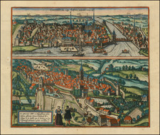
Fine example of this striking view of Zurich.
The following is a translation of the text on the verso by Braun:
Zurich is one of the oldest cities in Switzerland, built only 16 years after Trier. [...] In the year 1351 the people of Zurich forged an alliance with those of Uri and Schwyz. Readers will learn more about the city from Sebastian Münster, Johannes Stumpff, Josias Simmler, a citizen from Zurich, and from ancient and modern authors, including the most famous geographer of our times, Abraham Ortelius, in his atlas of the world.
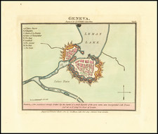
The engraving of the town, divided by the Limmat River, along with bridges crossing the river. The edge of Lake Zurich appears at the lower right-hand corner. In the foreground lies the Old Town, twin-towered Romanesque and Gothic Fraumunster, a former Benedictine nunnery, and further left the church of St Peter with a single tower. On the left, lime trees mark the Lindenhof, originally the site of Roman fort and subsequently, in the 9th century, an imperial palace. On the far side of the Limmat, the Wasserkirche lies directly on the river. The engraving shows
Engraved after a woodcut by Jos Murer, published in 1576.
Georg Braun (1541-1622) was born and died in Cologne. His primary vocation was as Catholic cleric; he spent thirty-seven years as canon and dean at the church St. Maria ad Gradus, in Cologne. Braun was the chief editor of the Civitates orbis terrarum, the greatest book of town views ever published. His job entailed hiring artists, acquiring source material for the maps and views, and writing the text. In this role, he was assisted by Abraham Ortelius. Braun lived into his 80s, and he was the only member of the original team to witness the publication of the sixth volume in 1617.
Frans Hogenberg (ca. 1540-ca. 1590) was a Flemish and German engraver and mapmaker who also painted. He was born in Mechelen, south of Antwerp, the son of wood engraver and etcher Nicolas Hogenberg. Together with his father, brother (Remigius), uncle, and cousins, Frans was one member of a prominent artistic family in the Netherlands.
During the 1550s, Frans worked in Antwerp with the famous mapmaker Abraham Ortelius. There, he engraved the maps for Ortelius’ groundbreaking first atlas, published in Antwerp in 1570, along with Johannes van Deotecum and Ambrosius and Ferdinand Arsenius. It is suspected he engraved the title page as well. Later, Ortelius supported Hogenberg with information for a different project, the Civitates orbis terrarium (edited by Georg Braun, engraved by Hogenberg, published in six volumes, Cologne, 1572-1617). Hogenberg engraved the majority of the work’s 546 prospects and views.
It is possible that Frans spent some time in England while fleeing from religious persecution, but he was living and working in Cologne by 1580. That is the city where he died around 1590. In addition to his maps, he is known for his historical allegories and portraits. His brother, Remigius, also went on to some fame as an engraver, and he died around the same time as his brother.
![[ Basel, Switzerland ] Basilea](https://storage.googleapis.com/raremaps/img/small/96903.jpg)