This item has been sold, but you can enter your email address to be notified if another example becomes available.


|
||

|

|
|

|
Stock# 54895
Description
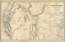
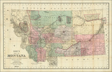
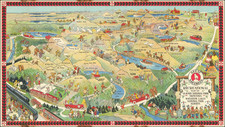
A large separate map of Montana Territory
Scarce map of the Territory of Montana, published in Chicago by H.R. Page & Co.
The map is hand colored by counties and shows cities, towns, rivers, etc.
Massive Indian Reservations dominate the entire territory, including Grove Ventre, Piegan, Blood, Blackfeet, River Crow, and Flathead, among others. Small Cheyenne resevation also shown in Custer County. Many early roads and forts shown.
One of only a few large format atlas maps of Montana Territory published in the 19th Century.