|
||

|

|
|

|
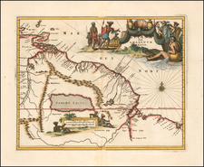
A "Pirated Dublin" Sea Chart of The Coast of South America, from the Orinoco River to the Amazon River.
Extremely rare sea chart of a portion of the northeastern coast of South America, centered on Guayana, Suriname and French Guiana, first published by George Grierson in 1749.
The map includes two inset maps, one tracking the Orinoco River from St. Thomas to the sea and one showing the Suriname River and environs.
George Grierson published only one edition of his The Fourth Book of the English Pilot in 1749. This is the second issue of the chart by Boulter Grierson published in 1767. The charts are from the same plates without change, even to the imprints.
After his death in 1753 his eldest son, George Abraham Grierson, continued the business, but for only two years. Upon the death of this son in 1755, his executors carried on until 1758, at which time a second son, Boulter, acquired possession. Boulter Gierson was the son of George's second wife, a sister to the noted printer James Blow of Belfast.
The map is very rare. This is the only example we have ever seen on the market.

![[ Venezuela ] Puerto Cavello on the Coast of Caracas; by Lt. Jones in 1741](https://storage.googleapis.com/raremaps/img/small/26585.jpg)
![[ Colombia & Venezuela ] Terra Firma & Nova Granada &c. Per N. Sanson](https://storage.googleapis.com/raremaps/img/small/97908.jpg)