


|
||

|

|
|

|
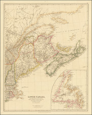
A Fine Pre-Lewis & Clark Map of Canada and the Transmississippi West.
Scarce map of Canada and the Transmississippi West, extending west to the Rocky Mountains and the MacKenzier River.
The map is based upon Aaron Arrowmsmith's monumental 1804 map of North America, the same map which Lewis & Clark carried with them on their expedition to the Pacific Ocean.
Perhaps the most interesting feature is the depiction of the headwaters of the Missouri River. Here, the map incorporates the reports of Peter Fidler for the Hudson's Bay Company, by including a series of possible river courses to the west, leading to (and prospectively through) the Rocky Mountains. It was this section of the map that provided the best depiction of the prospect of a water route or portage through the Rocky Mountains and to the Pacific.
It was this information derived from Peter Fidler and incorporated by Arrowsmith, along with reports from local Indians encountered on the expedition, which Lewis & Clark relied in choosing their path to the Rocky Mountains.
The map includes additional annotations of note, including a reference to the Indian report that once the Rocky Mountains were crossed, it was an 8 day trip to the Pacific and the reference to the Pearl Shell Lake on the eastern slope of the Rocky Mountains in the general vicinity of Denver, Colorado.
The details in Canada are also quite exceptional for such a small map, making use of the reports of Hearne, MacKenzie, and the Hudson Bay Company.
Russian factories are noted on the Alaskan coastline, with extensive Indian tribal information in the interior.
Excellent detail on the Pacific Coast, including a reference to the mythical "Riv. Oregan".
We have been unable to determine the source of the map, but it is quite similar to a map published by Longman, Hurst, Rees and Orme, which credits Arrowsmith.
The Arrowsmiths were a cartographic dynasty which operated from the late-eighteenth century to the mid-nineteenth. The family business was founded by Aaron Arrowsmith (1750-1823), who was renowned for carefully prepared and meticulously updated maps, globes, and charts. He created many maps that covered multiple sheets and which were massive in total size. His spare yet exacting style was recognized around the world and mapmakers from other countries, especially the young country of the United States, sought his maps and charts as exemplars for their own work.
Aaron Arrowsmith was born in County Durham in 1750. He came to London for work around 1770, where he found employment as a surveyor for the city’s mapmakers. By 1790, he had set up his own shop which specialized in general charts. Arrowsmith had five premises in his career, most of which were located on or near Soho Square, a neighborhood the led him to rub shoulders with the likes of Joseph Banks, the naturalist, and Matthew Flinders, the hydrographer.
Through his business ties and employment at the Hydrographic Office, Arrowsmith made other important relationships with Alexander Dalrymple, the Hudson’s Bay Company, and others entities. In 1810 he became Hydrographer to the Prince of Wales and, in 1820, Hydrographer to the King.
Aaron Arrowsmith died in 1823, whereby the business and title of Hydrographer to the King passed to his sons, Aaron and Samuel, and, later, his nephew, John. Aaron Jr. (1802-1854) was a founder member of the Royal Geographical Society (RGS) and left the family business in 1832; instead, he enrolled at Oxford to study to become a minister. Samuel (1805-1839) joined Aaron as a partner in the business and they traded together until Aaron left for the ministry. Samuel died at age 34 in 1839; his brother presided over his funeral. The remaining stock and copper plates were bought at auction by John Arrowsmith, their cousin.
John (1790-1873) operated his own independent business after his uncle, Aaron Arrowsmith Sr., died. After 1839, John moved into the Soho premises of his uncle and cousins. John enjoyed considerable recognition in the geography and exploration community. Like Aaron Jr., John was a founder member of the RGS and would serve as its unofficial cartographer for 43 years. Several geographical features in Australia and Canada are named after him. He carried the title Hydrographer to Queen Victoria. He died in 1873 and the majority of his stock was eventually bought by Edward Stanford, who co-founded Stanford’s map shop, which is still open in Covent Garden, London today.
![[Oregon Territory] Carte de l'Oregon (and) [Astoria Factory]](https://storage.googleapis.com/raremaps/img/small/77722.jpg)
![[California, Texas, and Southwest Globe Gore] with [Strait of Anian Globe Gore]](https://storage.googleapis.com/raremaps/img/small/99425.jpg)
![[ French & Indian War Battle Plan--Louisbourg ]. Plan De Louisbourg...](https://storage.googleapis.com/raremaps/img/small/57192.jpg)