|
||

|

|
|

|
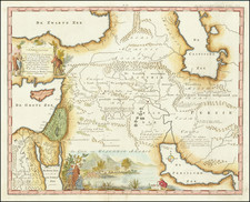
The Second Known Example of the Gastaldi-Strabo Map of Persia, etc.
Rare separately published regional map, based upon Strabo, showing Turkmenistan, Iran and the Caspian Sea.
A combination of modern geography and ancient place names used by Strabo, the map was unrecorded until a copy of the map was discovered by Peter Meurer in a unique sixteenth century composite atlas from the house of Bertelli in Venice; one of 15 previously unknown maps all utilizing information from Strabo. According with Meurer they are the "absolute scientific highlight of the atlas".
The Strabo maps were apparently created to illustrate an Italian edition of the books of the Geography by the Greek geographer, historian and philosopher Strabo, however there is no surviving example of an illustrated edition of Strabo's Geography published in Italy in the sixteenth century and no record of its publication. There was, however, a contemporary edition printed in Venice and Ferrara in 1562 and 1565. Contemporary map historians attribute the maps the Giacomo Gastaldi.
The maps in the series were designed on the basis of contemporary models, while the entries and names of towns regions, etc. follow the nomenclature of Strabo. None of the present maps are signed, but there exists a sole example of a second state of the general map of Italy in which the authorship is also assigned to Giacomo Gastaldi. Engraving with fine original coloring, in perfect condition.
Giacomo Gastaldi (1500-1566) is considered the foremost Italian cartographer of the sixteenth century, alongside Paolo Forlani. His skills of compilation are comparable to those of Mercator and Ortelius, yet much less is known of his life than of his two contemporaries. Gastaldi was born in Villafranca, Piedmont, but had established himself in Venice by 1539. He originally worked as an engineer, but turned to mapmaking from the 1540s onward.
It was in Venice where he made his reputation as an engraver, geographer, and cosmographer; for example, he was asked to fresco maps of Asia and Africa in the Palace of the Doge, or the Council of Ten, Venice’s governmental body. He also frequently consulted on projects for the Savi sopra la Laguna, drawing maps for this body which oversaw the regulation of fresh and salt water around Venice.
His contemporaries also recognized his skill, as he was named cosmographer to the Republic of Venice, was a member of the Accademia Veneziana, and was a major source for other geographers and mapmakers including Camocio, Bertelli, Cock, Luchini, and Ortelius. He even had his own distinct style of copper engraving that made him a pioneer in his day and makes his works iconic today.
Gastaldi enjoyed an especially productive relationship with Giovanni Battista Ramusio, Secretary of the Venetian Senate, who used Gastaldi's maps for his famous travel account collection, Navigationi et Viaggi. Gastaldi also tutored Ramusio's son in cosmography.
![[Map of the Persian Gulf]](https://storage.googleapis.com/raremaps/img/small/99842.jpg)
![[ Armenia, Georgia, Azerbaijan, Turkey ] Carte de la Georgie et Des Pays Situes Entre La Mer Noire et La Mer Caspienne . . .](https://storage.googleapis.com/raremaps/img/small/102202.jpg)