


|
||

|

|
|

|
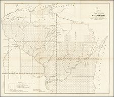
An Early Proposal For Canals Connecting The Mississippi River and Lake Michigan
Detailed map of the region beween the Mississippi River and Lake Michigan, intended to illustrate the possible routes for two canals connecting the river system to Lake Michigan.
This map is one of a series of maps made by Thomas Jefferson Cram of the U.S. Topographical Engineers from personal surveys and originally published in 1839, with the imprint of W.J. Stone in Washington.
The map covers the area from Green Bay to the juncture of the Mississippi and Missouri rivers and shows the canals in progress or proposed that would render navigation possible between Lake Michigan and the Mississippi River. Shown are:
- the Illinois and Michigan Canal, in progress between Chicago and Peru, on the Illinois River
- the proposed Milwaukee and Rock River Canal, in Wisconsin
- the canal proposed between Lake Winnebago and the Rock River in Wisconsin (unnamed).
The map was first published with the Report from the Secretary of War, transmitting, in compliance with a resolution of the Senate, copies of reports, plans and estimates for the improvement of the Neenah, Wiskonsin [sic] and Rock rivers, the improvement of the haven of Rock River, and the construction of a pier at the northern extremity of Winnebago Lake, issued in the United States Serial Set as Senate Doc. 318, 26th Congress, 1st session, 1840.
A edition of the map was printed in 1846, lacking the W.J. Stone imprint.
![North America Sheet IX Parts of Missouri, Illinois and Indiana [and the Sioux District]](https://storage.googleapis.com/raremaps/img/small/84193.jpg)
