The item illustrated and described below is sold, but we
have another example in stock. To view the example which
is currently being offered for sale, click the
"View Details" button below.
1869 American Photo-Lithographic Company
$ 675.00


|
||

|

|
|

|
Stock# 54729
Description
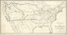
Fascinating large format map of the US, showing the progress of the 3 Transcontinental Railroad Lines, including lines completed and projected.
The map accompanied a 31 page Senate Report pamphlet entitled The Policy of Extending Government Aid to Additional Railroad ..., dated February 19, 1869.
Map by Joseph Gorlinsky, produced by the American Photo-Lithography Co., NY, using "Osborne's Process". From "The Policy of Extending Government Aid to Additional Railroad...," Senate Report 219, 40th Congress, 3rd Session. Shows completed and projected railroad routes. The final 70 miles or so joining the Central Pacific to the Union Pacific has yet to be completed.
Reference
Wheat 1207.


![[1958 World's Fair] The United States The Land of the People / Les Etats-Unis Le Pays et ses Habitants / De Verenigde Staten hed Land en het Volk](https://storage.googleapis.com/raremaps/img/small/76701.jpg)