This item has been sold, but you can enter your email address to be notified if another example becomes available.


|
||

|

|
|

|
Stock# 54699
Description
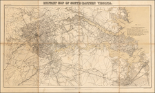
Color-lithographed map of the area near Gauley Bridge, (present-day) West Virginia.
Gauley Bridge was the site of a minor battle during the Civil War, which resulted in a Union victory.
"United States forces" are colored blue, and "Confederate forces & works" are red. The map shows the Union headquarters, towns, roads, houses, names of residents, drainage, and relief by hachures.
Condition Description
Small worm track in the bottom margin near the centerfold.
Reference
Stephenson, R.W. (CW) (1st ed.) #695.
![(U.S. Civil War) Panorama des Kriegsschauplatzes [Bird's-Eye View of the Theater of War Showing Virginia, Maryland, Deleware & Columbia]](https://storage.googleapis.com/raremaps/img/small/99760.jpg)