
The item illustrated and described below is sold, but we
have another example in stock. To view the example which
is currently being offered for sale, click the
"View Details" button below.
1865 United States Bureau of Topographical Engineers
$ 275.00


|
||

|

|
|

|
Stock# 54655
Description
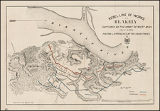
Fine example of this scarce map of the Rebel Fortifications near the confluence of the Blakely and Tensaw Rivers, between Jackson and Mobile, Alabama.
The positions of the Union (blue) and Confederate lines and works are shown, along with roads, topographical details and battery positions.
This is the first edition of the map, distinguishable from the second, by the color printing of the "Union Works" and "Confederate Works".
Reference
Stephenson, R.W. (CW) 104

![[ French Louisiana ] Carte De la Louisiane par Le Sr. D'Anville Dressee en Mai 1732. Publiee en 1752](https://storage.googleapis.com/raremaps/img/small/88804.jpg)
![[Alabama, Mississippi, Arkansas, Louisiana and part of Tennessee and Western Florida] Amer. Sep. No. 56 Partie des États Unis](https://storage.googleapis.com/raremaps/img/small/93538.jpg)