|
||

|

|
|

|
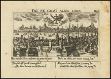
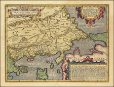
Striking Second State of Braun & Hogenberg's Important View of Istanbul
Important early bird’s-eye-view of Istanbul, from Braun and Hogenberg's monumental town book.
This is the second state of the view, with the roundel at the right filled with the portrait of Sultan Murad III. This roundel is blank in state one.
The Braun and Hogenberg view is one of the finest and most sought-after depictions of Istanbul. Viewed across the Bosphorus from the village of Scutari (Üsküdar), the city is shown with an emphasis on its fortifications and famous buildings. Pera-Galata is across the Golden Horn, to the right of the view.
Many of the great buildings of the city are evident, including the Topkapi Palace. The Hagia Sophia is near to the palace, while the many-domed Fatih Mosque complex sprawls toward the western city walls. Just outside the city walls, at left, is the rising Tekfur Palace. In Pera are the new shipyards.
Along the view’s lower edge, Suleiman the Magnificent rides at the center. The Ottomans sultans have their portraits on either side of him, from Osman Bey to Murad III.
Sixteenth-century mapping of Istanbul
This view is part of a sequence of that showed the city as it grew in size and importance in the sixteenth century. The first surviving map to show a bird’s-eye-view of the city in this configuration was by Giovanni Andrea Vavassore. Published in Venice in 1520, the view is clearly the inspiration for later productions by Sebastian Münster (1544) and Braun and Hogenberg (1572). Vavassore, in turn, supposedly based his view on a 1480 map by Giovanni Bellini, but it has not survived.
Both Münster and Braun and Hogenberg improved upon their predecessor’s work, adding details to the grand buildings of the city. For example, the Hippodrome is much more accurately rendered, while many other churches and administrative buildings are more precisely located and depicted.
The main difference between the Münster and the Braun and Hogenberg are the decorative features along the bottom of the view. Sulieman the Magnificent (1494-1566) sits proudly atop a majestic steed, surrounded by armed attendants. To his left and right are roundels showing the sultans of the Ottoman Empire.
Sulieman strengthened the empire and terrified the Christian leaders of Europe. The title of the Braun and Hogbenberg view, Byzantium Nunc Costantinopolis, is likely a European attempt to undermine the legitimacy of the Ottomans, suggesting the earlier presence and power of the Byzantine Empire.
This view of the city continued to be influential, affecting the layout of views well into the following century. For example, Jansson reprinted the Braun and Hogenberg view (which appeared in two states) in a third state in his own town book in the mid-seventeenth century. Versions of the view were printed into the nineteenth century.
Constantinople
The city of Istanbul, previously known as Constantinople, has its roots in the seventh century BCE. By the first century BCE, Byzantium was a thriving settlement. The independence of the city ended in the late second century CE, when Septimus Severus and his Roman army conquered it by siege. Severus rebuilt the damage he caused and the city soon became a prominent Roman metropolis thanks in large part to the its natural defensibility and strategic location.
These attributes led Constantine the Great to make the city the capital of the Roman Empire; it was renamed Constantinople in 330 CE. A Christian city, Constantinople was soon defined by its churches, including the Hagia Sophia and the Hagia Irene.
The city survived the fall of Rome and continued to fashion themselves as the heir to the Roman Empire for over a thousand years. The Ottomans conquered Constantinople in 1453, making it the capital of their own empire. The Turkish government changed the city’s name to Istanbul in 1930.
Interestingly, the term Byzantine was not applied to an empire until the nineteenth century. First coined by a Hapsburg scholar, Hieronymous Wolf, in 1557, it was taken up by historians to refer to the later or eastern Roman Empire.
Georg Braun (1541-1622) was born and died in Cologne. His primary vocation was as Catholic cleric; he spent thirty-seven years as canon and dean at the church St. Maria ad Gradus, in Cologne. Braun was the chief editor of the Civitates orbis terrarum, the greatest book of town views ever published. His job entailed hiring artists, acquiring source material for the maps and views, and writing the text. In this role, he was assisted by Abraham Ortelius. Braun lived into his 80s, and he was the only member of the original team to witness the publication of the sixth volume in 1617.
Frans Hogenberg (ca. 1540-ca. 1590) was a Flemish and German engraver and mapmaker who also painted. He was born in Mechelen, south of Antwerp, the son of wood engraver and etcher Nicolas Hogenberg. Together with his father, brother (Remigius), uncle, and cousins, Frans was one member of a prominent artistic family in the Netherlands.
During the 1550s, Frans worked in Antwerp with the famous mapmaker Abraham Ortelius. There, he engraved the maps for Ortelius’ groundbreaking first atlas, published in Antwerp in 1570, along with Johannes van Deotecum and Ambrosius and Ferdinand Arsenius. It is suspected he engraved the title page as well. Later, Ortelius supported Hogenberg with information for a different project, the Civitates orbis terrarium (edited by Georg Braun, engraved by Hogenberg, published in six volumes, Cologne, 1572-1617). Hogenberg engraved the majority of the work’s 546 prospects and views.
It is possible that Frans spent some time in England while fleeing from religious persecution, but he was living and working in Cologne by 1580. That is the city where he died around 1590. In addition to his maps, he is known for his historical allegories and portraits. His brother, Remigius, also went on to some fame as an engraver, and he died around the same time as his brother.