


|
||

|

|
|

|
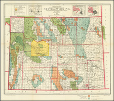
A Superb Collection of Manuscript Maps Documenting the Course of the Union Pacific as it Approached and Passed the Continental Divide in Wyoming. Made By One of the UPRR's Most Important Engineers.
A collection of seven skillfully-executed unique field surveys in pen-and-ink on saffron paper (sometimes with multiple sheets neatly composited to form larger images). The maps were executed by Henry Harding, a UPRR engineer, in 1868, as the eastern stretch of the Union Pacific moved closer to Promontory Summit, Utah Territory. This collection of maps shows the railroad just as it crosses the Continental Divide and approached the golden spike.
Original manuscript field surveys of Union Pacific are exceptionally rare; this group and two other surveys also from Harding are the only examples that we have seen on the market.
Altogether, these maps cover over one-third of the Union Pacific track through the state of Wyoming.
The Impact of the Union Pacific on Wyoming
In Gregory Nickerson's Industry, Politics and Power: the Union Pacific in Wyoming he describes the impact of the railroad on the state:
The building of the Union Pacific across Wyoming forever changed the political and physical landscape, not least by bringing about the organization of Wyoming Territory out of a huge piece of land lopped off the southwestern part of Dakota Territory.
The region needed its own government because of its remoteness from the capital of Dakota Territory at Yankton on the Missouri River. Wyoming Territory also took a small part of Utah and Idaho territory in the west of the continental divide. (The northern boundary of Wyoming Territory was defined by the organization of Montana Territory in 1864.)
When the UP first came to Wyoming in 1867, the railroad exerted a tremendous amount of influence on the government. Often it seemed that governments existed primarily to serve the interests of the railroad, first with federal military support to pacify Indians, unruly squatters or striking coal miners, and then by creating the structure of territorial government needed for conducting business.
In Gov. John A. Campbell's 1869 inaugural address to the Wyoming Territorial Legislature, he noted that, "For the first time in the history of our country, the organization of a territorial government was rendered necessary by the building of a railroad. Heretofore the railroad has been the follower instead of the pioneer of civilization."
As leaders of one of the largest private landholders and employers, UP executives made decisions that affected every town and impacted the wealth of Wyoming. Territorial officials fought for the right to tax property owned by the railroad and ultimately prevailed in an 1873 court case. After this, Wyoming Territory collected one-third of its property taxes from the UP right of way, track and rolling stock.
Contents of the Collection
The map covers hundreds of miles in two sections; the first from just north of Rock River, Wyoming to Riner, Wyoming, and the second from the east of Table Rock, Wyoming just to the west of the Green River. We have prepared a composite digital image that shows the areas encompassed by the collection, and it is available upon request.
List of the contents:
1. Location. From Station 5000 to North Platte. 24 x 79”. Scale 1000 ft. to one inch. Shows an approximately 15 mile stretch in south-central Wyoming, miles 680 to 695, through the Rattlesnake Hills, terminating at the North Platte River [detail pictured opposite].
2. [Docketed:] North Platte West. Station 3924 to Green River. 21 1/2” x 67”. Scale 1 mile to the inch.
3. [No Title]. 20” x 24”. Shows 20 miles in south-central Wyoming, miles 700 to 720, including the site of the future town of Rawlings.
4. [No Title]. 20” x 24”. South central Wyoming. Penciled notation on verso states that this survey covers miles 680 to 700.
5. [No title]. 16 1/2” x 22”. South central Wyoming, in the Rattlesnake Hills (see IIa.) Fort Halleck (abandoned 1866) is shown at lower center.
6. U.P.R.R. Map of the 22d Section Examined. 19 1/4” x 20 1/8”. Scale 1 mile to the inch.
7. [No title]. 16” x 20”. Unidentified survey.
A unique collection that would make a worthy addition to any serious private or institutional collection focused on the West, Wyoming, or the Transcontinental Railroad.
Henry Harding (1837-1910) was a railroad engineer from Hartland, Vermont.
Harding worked for multiple eastern railroads during the 1850s, until he was recruited to serve as an assistant engineer for the Union Pacific under the direction of Grenville Mellon Dodge, an old friend and Chief Engineer of the railroad. Harding worked on the Union Pacific from 1865 to1870, Harding’s particular focus was the design and construction of structures such as bridges, station houses, round houses, and terminals.
After the completion of the Union Pacific / Transcontinental Railraod, Harding returned East, working briefly for the Adirondac, Housatonic, and Naguatuck Railroads, befor taking a job with the United States Engineering Corps from 1873-90, and finally retiring to Hartland, Virginia in 1890.
For a more complete account of Harding’s career, see Ellis, W.A., Norwich University, 1819-1911, Her History, Her Graduates, Her Role of Honor. Published by Major-General Grenville M. Dodge, 1911.
![[ Jackson Hole and Environs ] Geological Map of Portions of Wyoming, Idaho and Utah](https://storage.googleapis.com/raremaps/img/small/97191.jpg)
![[Montana, Wyoming, Dakota, Upper Missouri River] Amer. Sep. No. 40. Partie des Etats Unis](https://storage.googleapis.com/raremaps/img/small/93546.jpg)

![(Photograph album) America | Hawaii. 1885. [Photographic album of Hawaii, Yellowstone, Utah, Colorado, and Niagara Falls]](https://storage.googleapis.com/raremaps/img/small/87949.jpg)