|
||

|

|
|

|
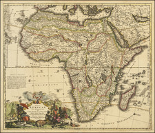
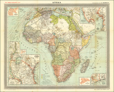
Beautiful, Large 17th-Century Wall Map of Africa by Jaillot after Blaeu.
A stunning, hand-colored, engraved wall map of Africa, with carte-a-figure panels featuring local costumes, peoples, and city views. It was published by Alexis-Hubert Jaillot in Paris in 1669, following the famous Blaeu wall map of Africa from 1608.
The map features extensive decoration with sea monsters and ships in full sail. On the land, it includes illustrations of lions, ostriches, elephants, and rhinos. The map is hand-colored, with each kingdom colored separately. In the upper right corner is a cartouche with two African women flanking a white man; it contains the title and date of publication. In the lower left is a dual hemisphere cartouche which explains how to calculate distances with triangles; a monkey sits atop the spheres. In the upper left is a final, smaller cartouche with Jaillot’s name and the date repeated.
The views in the bottom panel feature Tangiers, Algiers, Tunis, Alexandria, Cairo and other cities; they are taken from Braun & Hogenberg's Civitates Orbis Terrarum. Along each side are eight vignettes featuring the people, costumes, and exemplary customs of people from the major cities and civilizations of Africa. They reveal what knowledge and perspectives Europeans had of Africa and Africans in the seventeenth century.
Betz explains:
Reflecting the importance of Willem Blaeu's 1608 wall map of Africa, it was copied in France by Alexis-Hubert Jaillot. Geographically, the map is identical to Blaeu's wall map of 1608. One major change is that the Latin nomenclature on the map has been translated into French by Jaillot, thus making the map more accessible to Jaillot's reading audience. Another difference is that this map does not have the cartouche containing the privilege on the bottom right sheet which was on the Blaeu 1608 map.
This wall map was one of Alexis-Hubert Jaillot's first works, published shortly after he took over the business from his brother-in-law Nicolas Berey II (1640-1667) upon Berey's death in 1667. Nicolas Berey I, the father, had already died in 1665.
Blaeu and his wall maps
Willem Janszoon Blaeu (1571-1638) was a prominent Dutch geographer and publisher. Born the son of a herring merchant, Blaeu chose not fish but mathematics and astronomy for his focus. He studied with the famous Danish astronomer Tycho Brahe, with whom he honed his instrument and globe making skills. Blaeu set up shop in Amsterdam, where he sold instruments and globes, published maps, and edited the works of intellectuals like Descartes and Hugo Grotius.
Willem died in 1638. He had two sons, Cornelis (1610-1648) and Joan (1596-1673). Joan trained as a lawyer but joined his father’s business rather than practice. After his father’s death, the brothers took over their father’s shop and Joan took on his work as hydrographer to the Dutch East India Company (VOC). The shop burned in 1672.
One of Willem Blaeu best known works are his fabulous wall maps. First published in 1608, they were one of the first pieces that established his shop, the Officiana Blaviana, as the premier Amsterdam cartography establishment of its age. The set consists of a map of each of four continents and a world map.
To ensure the maps were of the highest quality, Blaeu called on the expertise and engraving skill of Hessel Gerritsz. Gerritsz was already successful n the competitive Amsterdam trade and served as the first hydrographer to the VOC; Blaeu would become the second. For the decorative elements, Blaeu hired Johsua van de Ende to engrave the side and city view panels.
Blaeu published a second edition of the maps in 1612. Then the plates went to Hendrik Hondius, who brought out an edition in 1624, then Nicholas Visscher did the same in 1655-7. In Venice, Stefano Scolari published a derivative set in 1646. Jaillot and Berey used the 1608 edition as their guide, harkening to the original masterpiece.
These maps were extremely influential both for their geography and for their style; they set the tone for all decorative wall maps of the seventeenth century. Each surviving example—original or later edition—is extremely rare; there is only one known set of the 1608 maps, but it is lacking the Africa map. Jaillot’s version is an exquisite item, and it is valuable to the history of cartography thanks to its connection with Blaeu.
Made before 1669?
Schilder (1996) and Betz suggest that the map was produced by Jaillot and the Bereys prior to the 1669 date in the cartouche. This is based on the surrounding text that refers to "Nicolas Berey, Enlumineur du Roy", which was most likely the father Berey, as the son would have been very young to hold that title in 1669. Because the father Berey died in 1665, Betz and Schilder believe that the map was started when Jaillot joined the business upon his marriage to Berey's daughter in 1664. This subject needs further study, as Nicolas Berey II was 37 when he died in 1667, and not too young to hold the title "Enlumieur du Roy".
Willem Janszoon Blaeu (1571-1638) was a prominent Dutch geographer and publisher. Born the son of a herring merchant, Blaeu chose not fish but mathematics and astronomy for his focus. He studied with the famous Danish astronomer Tycho Brahe, with whom he honed his instrument and globe making skills. Blaeu set up shop in Amsterdam, where he sold instruments and globes, published maps, and edited the works of intellectuals like Descartes and Hugo Grotius. In 1635, he released his atlas, Theatrum Orbis Terrarum, sive, Atlas novus.
Willem died in 1638. He had two sons, Cornelis (1610-1648) and Joan (1596-1673). Joan trained as a lawyer, but joined his father’s business rather than practice. After his father’s death, the brothers took over their father’s shop and Joan took on his work as hydrographer to the Dutch East India Company. Later in life, Joan would modify and greatly expand his father’s Atlas novus, eventually releasing his masterpiece, the Atlas maior, between 1662 and 1672.
Alexis-Hubert Jaillot (ca. 1632-1712) was one of the most important French cartographers of the seventeenth century. Jaillot traveled to Paris with his brother, Simon, in 1657, hoping to take advantage of Louis XIV's call to the artists and scientists of France to settle and work in Paris. Originally a sculptor, he married the daughter of Nicholas Berey, Jeanne Berey, in 1664, and went into partnership with Nicholas Sanson's sons. Beginning in 1669, he re-engraved and often enlarged many of Sanson's maps, filling in the gap left by the destruction of the Blaeu's printing establishment in 1672.
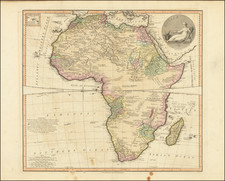
![[Wall Map of Africa] L'Afrique Divisee en ses Principales Parties et ses Isles Tire des Relations les plus Recentes . . . 1782](https://storage.googleapis.com/raremaps/img/small/91459.jpg)