|
||

|

|
|

|
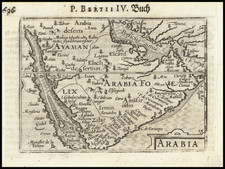
Striking large format map of Arabia and the Red Sea, published by Valk & Schenk, utilizing Jansson's original plate.
The map references the "Mare Elcatif or Sinus Persicus," showing both the Persian and Arab names for the Gulf between Persia and Saudi Arabia. This reflects both the name used by Ptolemy (150AD) and more modern names. Ptolemy relied upon Indika, written by Flavus Arrianus and Strabo for his use of the term "Sinus Persicus." The earliest recorded Arabic language names for the Gulf were:
- Bahr Faris (Sea of Persia)
- Al-bahr al-Akhdar (the Green Sea)
- Al-khalij al Akhdar (Green Gulf)
Includes 2 decorative cartouches, lions, camels, elephants, sea monsters and sailing ships.
One of the most decorative of all 17th century large format maps of Saudi Arabia.
In the 16th century, the Ottomans added the Red Sea and Persian Gulf Coast to the empire and claimed suzerainty over the interior. The main objective of this was to thwart Portuguese attempts to attack the Red Sea and the Indian Ocean. The Ottoman Turks conquered the area around Basra and invaded the Arabian Coast as far as Qatif, which they occupied, removing the Portuguese from the region. The Turks adopted the names Gulf of Basrah, Gulf of Qatif and Gulf of Arabia.
From 1572 onward, the name Mare Elcatif began to appear on maps. Persian Shah Abbas dislodge the Portuguese from Bahrain (1602) and, with English help, from Hormuz (1622), in the Persian Gulf. He expanded commercial links with the English East India Company and the Dutch East India Company. During the mid-1600s and 1700s, the Arabian Peninsula was a major focal point of European trade interests.
Jan Janssonius (also known as Johann or Jan Jansson or Janszoon) (1588-1664) was a renowned geographer and publisher of the seventeenth century, when the Dutch dominated map publishing in Europe. Born in Arnhem, Jan was first exposed to the trade via his father, who was also a bookseller and publisher. In 1612, Jan married the daughter of Jodocus Hondius, who was also a prominent mapmaker and seller. Jonssonius’ first maps date from 1616.
In the 1630s, Janssonius worked with his brother-in-law, Henricus Hondius. Their most successful venture was to reissue the Mercator-Hondius atlas. Jodocus Hondius had acquired the plates to the Mercator atlas, first published in 1595, and added 36 additional maps. After Hondius died in 1612, Henricus took over publication; Janssonius joined the venture in 1633. Eventually, the atlas was renamed the Atlas Novus and then the Atlas Major, by which time it had expanded to eleven volumes. Janssonius is also well known for his volume of English county maps, published in 1646.
Janssonius died in Amsterdam in 1664. His son-in-law, Johannes van Waesbergen, took over his business. Eventually, many of Janssonius’ plates were sold to Gerard Valck and Pieter Schenk, who added their names and continued to reissue the maps.
![Arabia, Petraea et Deserta [Saudi Arabia, etc.]](https://storage.googleapis.com/raremaps/img/small/87833.jpg)