This item has been sold, but you can enter your email address to be notified if another example becomes available.


|
||

|

|
|

|
Stock# 54437
Description
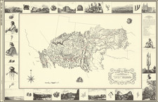
Detailed map of Southern California, published by the State Oil & Gas Supervisor.
The map extends from Santa Barbara and San Bernardino Counties to Temecula.
The map details Wildcat Wells in the region, plus the pipe lines of 8 companies:
- Associated Oil Co.
- Standard Oil Co.
- General Pet. Co.
- Petroleum Midway
- Shell Oil of Calif
- Union Oil Co.
- Pan American Pet. Co.
- Producers Trans. Co.
The map shows oil fields, fields discovered between 1914 and 1924, Wildcat Wells, Discovery Wells and index numbers.
The map is quite rare. We have not been able to locate any other examples.
Condition Description
Some minor staining
![National Map Company's California Showing Counties, Cities, Villages, and Post Offices[,] Steam and Electric Railroads, with Stations and Distances between Stations[,] National Forests, Reservations, Parks, Etc.](https://storage.googleapis.com/raremaps/img/small/92408.jpg)
![[San Juan Capistrano to San Onofre] Capistrano Quadrangle](https://storage.googleapis.com/raremaps/img/small/83563.jpg)