


|
||

|

|
|

|
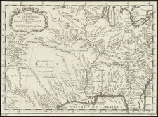
First State of Sartine's Revolutionary War Sea Chart of the Southeastern British Colonies
Nice example of Antoine Sartine's map of the the Southeastern Atlantic Coast, from the Chesapeake and Delaware Bays to the mouth of the St. John River.
The map was prepared under the direction of the French Depot De La Marine at the outset of the American Revolution and included in the Neptune americo-septentrionale. The work was intended for use by the French Navy during the Revolutionary War.
While at first blush, the chart appears to be a coast chart, in fact, its charm lies as much for what it shows in the interior parts of the Carolinas. The chart includes dozens of early roads, forts and towns, as well as excellent detail in locating the various Indian Lands east of the Appalachians.
The map includes a tremendous amount of coastal and inland detail, including the location of dozens of churches, with denominations. Annotations include an Assembly of Non-conformists in western North Carolina (Franklinites?), and many other interesting notes. Along the coast, the islands, capes, soundings and other coastal details are provided in tremendous detail.
Intended for use during the American Revolution, this chart would have been aboard the French ships blockading Yorktown and generally aiding the American cause.


![(Civil War) Stanford's Map of the Seat of War in America. Sheet I. [Mid-Atlantic States]](https://storage.googleapis.com/raremaps/img/small/96007.jpg)