


|
||

|

|
|

|
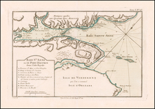
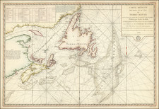
Detailed map of the Gulf of St. Lawrence, Nova Scotia, Newfoundland and the Grand Banks, published shortly after the signing of the Treaties of Versailles in 1783.
The present map was created shortly after the signing of the treaty between England and France signed on January 20, 1783, which resulted in the English retaining Newfoundland and adjacent islands, except for Saint Pierre and Miquelon (retained by the French). It is substantially similar to the copy of the map held by the Bibliotheque National de France, which includes the relevant portions of the treaties between the French and English signed in 1713, 1763 and 1783.
The manuscript note in Newfoundland states:
La partie coloree en vert a ete cedee a l'Angleterre par le traite de 1783, poour la partie contestee en 1763, depuis la fausse pointe Riche, ou le Cap Double jusqu'au Cap de Raye.
(Translation: The green colored part was ceded to England by the Treaty of 1783, for the disputed part in 1763, from the false Riche point, or Cape Double to Cape Raye.)
The chart was produced by the Depot de la Marine shortly after the end of the American Revolution and became the primary map used by the French Government to manage its extensive fishing rights in Newfoundland and the Grand Banks following the 1783 Treaty. The chart meticulously details the coastal details and offshore bank, with soundings. The tracks of several Fench ships which had recently completed fishing and reconnaissance missions to the region are shown.
Following the conclusion of the Seven Years' War, the Treaty of Paris provided that Britain transfer the islands of St. Pierre and Miquelon (labeled in red) to France. The French were also granted fishing rights along Newfoundland's shores and Grand Banks.
In 1763, Admiral Thomas Graves, the Governor of Newfoundland, appointed Lt. James Cook (1728-79) to survey the shores of Newfoundland and southern Labrador. Cook was assisted by Michael Lane. Over the course of the next decade, first under Cook's leadership and later under Lane's leadership, the region was surveyed in meticulous detail. The resulting General Chart Of The Island Of Newfoundland with the Rocks & Soundings. . . . was published in 1775 .
Rarity
It is known that a few examples of the chart featuring manuscript annotations relating to the fishing rights still survive in official French collections. However, we are not aware of any other examples of the map with these apparently official annotations appearing on the market.
The Dépôt de la Marine, known more formally as the Dépôt des cartes et plans de la Marine, was the central charting institution of France. The centralization of hydrography in France began in earnest when Jean-Baptiste Colbert became First Minister of France in 1661. Under his watch, the first Royal School of Hydrography began operating, as did the first survey of France’s coasts (1670-1689). In 1680, Colbert consolidated various collections of charts and memoirs into a single assemblage, forming the core of sources for what would become the Dépôt.
The Dépôt itself began as the central deposit of charts for the French Navy. In 1720, the Navy consolidated its collection with those government materials covering the colonies, creating a single large repository of navigation. By 1737, the Dépôt was creating its own original charts and, from 1750, they participated in scientific expeditions to determine the accurate calculation of longitude.
In 1773, the Dépôt received a monopoly over the composition, production, and distribution of navigational materials, solidifying their place as the main producer of geographic knowledge in France. Dépôt-approved charts were distributed to official warehouses in port cities and sold by authorized merchants. The charts were of the highest quality, as many of France’s premier mapmakers worked at the Dépôt in the eighteenth century, including Philippe Bauche, Jacques-Nicolas Bellin, Rigobert Bonne, Jean Nicolas Buache, and Charles-François Beautemps-Beaupré.
The Dépôt continued to operate until 1886, when it became the Naval Hydrographic Service. In 1971, it changed names again, this time to the Naval and Oceanographic Service (SHOM). Although its name has changed, its purpose is largely the same, to provide high quality cartographic and scientific information to the France’s Navy and merchant marine.
![[Heightened with Gold] Paskaert Zynde de Noordelijckste Zeekusten van America van Groenland door de Straet Davis en de Straet Hudson tot Terra Neuf . . .](https://storage.googleapis.com/raremaps/img/small/93148.jpg)

![Carte Du Canada ou de la Nouvelle France et des Decouvertes qui y ont ete faites . . . [Map of Canada or New France and the Discoveries Made Therein . . .]](https://storage.googleapis.com/raremaps/img/small/94450.jpg)