|
||

|

|
|

|
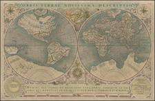
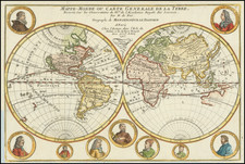
Rare world map by Pierre Moullart-Sanson, demonstrating a revolutionary means of finding longitude.
This world map on Mercator's projection shows a means of recording the day's length according to the sun's Zodiacal position thus allowing (in theory) a means of calculating degrees of longitude.
The full title is:
Mappemonde ou carte marine universelle reduite : où sont l'Asie, l'Afrique, l'Europe, l'Amerique septentrionale, l'Amerique meridionale / par Pierre Moullart-Sanson, geographe du Roi. L'ontrouve sur les paralleles ou degrés de latitude de cette carte les heures des jours selon le signe où se trouve le soleil, la difference des ombres, par le moïen des quelles feu Mr. d'Estoubeuille pretendoit demonstrer les longitudes.
(World map or reduced universal marine map: where are Asia, Africa, Europe, North America, South America / by Pierre Moullart-Sanson, geographer of the King. We find on the parallel or degrees of latitude of this map the hours of days according to the sign where the sun is, the difference of the shadows, by the mean of which M. d'Estoubeville attempted to demonstrate the longitudes.)
Rarity
The map is quite rare on the market. We locate only 2 examples in AMPR (Potter 1995 and Arkway 2001). This is the example offered by Arkway in 2001, sold to Bill Ginsberg and resold at Swann Auctions in 2017.
![Nova Totius Terrarum Orbis Geographica Ac Hydrographica Tabula. A Pet. Kaerio [First State -- With Handwritten Account of Sir Francis Drake's Voyage on the verso]](https://storage.googleapis.com/raremaps/img/small/81200.jpg)