|
||

|

|
|

|
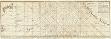
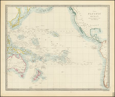
Gorgeous full color example of La Perouse's map of the Pacific Ocean on Mercator's projection.
The map highlights in blue La Perouse's Voyage from France, around Cape Horn, then to Hawaii and the Northwest Coast of America, south to Oregon, San Francisco and Monterey, then across the Pacific Ocean to Canton, through the Philippines to the Sea of Japan and the Northern Japanese Islands, then to Kamchatka.
From Kamchatka, La Perouse proceeded to the South Pacific and finally to Port Jackson and Botany Bay, where he met his untimely death. The map displays the most up to date cartography, especially along the Northwest Coast of America, Northeast Coast of Asia, Australia, New Zealand and the Pacific.
La Perouse arrived in Botany Bay in 1788, where he was welcomed by the British and stayed six weeks, during which time he arranged for his records to be sent back to Europe. He then set sail, saying he would be back in Paris by June 1789, but none of his crew were ever seen again. In 1826 evidence of the fate of the expedition was found on Vanikoro in the Santa Cruz group of islands. In 2005, it was proved the Boussole and Astrolabe had hit the reefs there and sank.
La Perouse's voyage is perhaps second only to the Voyages of James Cook for its impact on cartographic knowledge and discoveries in the Pacific during the second half of the 18th Century.
![[Heightened with Gold!] Paskaerte Zynde t'Oosterdeel Van Oost Indien, met alle de Eylanden daer ontrendt geleegen van C. Comorin tota aen Iapan](https://storage.googleapis.com/raremaps/img/small/83769.jpg)