


|
||

|

|
|

|
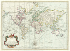
Rare First State of Plancius' 1590 World Map
Fine example of the rare first state of Petrus Plancius' double-hemisphere map of the world, engraved by Baptista Van Deutecum in Amsterdam in 1590.
The eastern hemisphere includes an odd depiction of Japan, showing it as a round cluster of islands. In China, the guard towers of the Great Wall are visible.
The Atlantic is filled with storied islands, including Frisland (see below) St. Brendan, and Brasil. Hy Brasil is an enduring Atlantic chimera emerging from Celtic folklore. It ranges on maps from just off the west coast of Ireland to the area around the Azores. The island was initially described as a rich paradise not unlike Atlantis; it emerged from the depths for a short period and then would disappear. It started to appear on portolan charts in the fourteenth century and continued to be a stalwart of maps and charts into the nineteenth century. The island was the subject of a fanciful pamphlet by Richard Head in 1675. Despite no accurate reports of its whereabouts, the island appeared on Admiralty charts and other reputable maps for centuries, usually in the latitude of 51°N and at a longitude of 17°W.
Another island of note, at the edge of the western hemisphere on this map, is St. Brendan (here S. Brandain). Like Hy Brasil, this island is also connected to Irish lore. St. Brendan, hearing of a promised land from St. Barrind, decided to take a group of monks to find the paradise in the sixth century. After 43 days the monks landed on a deserted island. This is only the first of a series of islands which they encountered, before facing a frozen sea. They supposedly had more adventures and eventually return home. The island itself varied in its placement, ranging from near the Canary Islands to close to Newfoundland.
Farther south in the western hemisphere, South America has been improved in shape as compared to the central source for this map, the 1587 world map of Rumold Mercator. The continent no longer has a bulge in the southwest. It tapers delicately to a point, where it is separated from a southern continent by the Strait of Magellan.
In the Pacific, north of the Equator, islands encountered by the Spanish in their creation of the Manila-Acapulco galleon route are scattered about. South of the equator, a large, round New Guinea dominates the space, accompanied to the east by the Solomon Islands. The latter had been visited by Alvaro de Mendaña’s expedition in his 1567-9 voyage.
Separating Asia and North America is the Estreco de Anian and inland, in the northwest, is Anian regnum. The Strait of Anian derives from Ania, a Chinese province on a large gulf mentioned in Marco Polo’s travels (ch. 5, book 3). The gulf Polo described was actually the Gulf of Tonkin, but the province’s description was transposed from Vietnam to the northwest coast of North America. The first map to do so was Giacomo Gastaldi’s world map of 1562, followed by Zaltieri and Mercator in 1567. The Strait then became shorthand for a passage to China, i.e. a Northwest Passage. It appeared on maps until the mid-eighteenth century.
In southwest North America is Quivira reg. Quivira refers to the Seven Cities of Gold sought by the Spanish explorer Francisco Vasquez de Coronado. In 1539, Coronado wandered over what today is Arizona and New Mexico, eventually heading to what is now Kansas to find the supposedly rich city of Quivira. Although he never found the cities or the gold, the name stuck on maps, wandering from east to west.
Another distinctive feature here is the adoption of the four-island conception of the North Pole. This depiction is similar to how the Arctic is shown on the Behaim globe (1492). This four-island representation would later be taken up by Gerard Mercator and others for the following two hundred years. The idea for it comes from De Inventio Fortuna, a now-lost fourteenth-century book describing a magnetic island, Rupes Nigra, that is surrounded by a whirlpool and four large islands.
While the map is geographically intriguing, it is also aesthetically engaging. The scrollwork lettering is delicate, while the large ship and the sea monster are finely-wrought. The intricate cut-out pattern framing the hemispheres has an embedded compass rose and armillary sphere.
Terra Australis
One of the defining characteristics of this map is the massive southern continent that fills the southerly latitudes, Magallanica Terra Australis. A peninsula juts up near southeast Asia. Place names there include Beach, Lucach, and Maletur. As with Anian, they would be familiar to anyone who has read Marco Polo’s Travels. These three places were originally regions in Java. As can be seen, a Java menor is near to Maletur. This conflation of Java with the southern continent stemmed from an error. Initially, Polo used Arabic usage of Java Major for Java and Java Minor for Sumatra. After a printing mistake made Java Minor seem the largest island in the world in the 1532 edition of Polo’s Travels (Paris and Basel), mapmakers started to make a landmass to accommodate Java Minor, Beach, Lucach, and Maletur.
Farther west is Psitacorum regio, which refers to an area densely populated with parrots. This place name appeared on Mercator’s 1541 globe and his 1569 world map. It was supposed to have been sighted by Portuguese sailors but was never verified in terms of size or location.
States of the map
Plancius's map first appeared in 1590, with Plancius' name in the title, although Shirley explains that there is a proof state at the British Library which lacks the toponym Magallanica. A later state appeared in 1612 and 1621, with the name or phrase D.R.M. Mathes in the title and Plancius’ name removed. All three (1590, 1612, and 1621) appeared in bibles.
The present example is a first state with Plancius’ name.
Sources and rarity
One of Plancius’ earliest world maps, this map is based on Rumold Mercator's famous world map, which was first published in 1587. However, the present map has corrections to the shape of South America and includes the Solomon Islands, as derived from Ortelius. In addition to these changes, Plancius uses information derived from the latest Portuguese sources to derive the west coast of America and the east coast of Asia.
This map is considerably rarer than Mercator's map. As Shirley notes, "most of the maps prepared by Plancius are uncommon, if not rare, as they were not reprinted in standard atlas form."
The Zeno Map and the mythical island of Frisland
The Zeno family was part of the Venetian elite; indeed, their family had controlled the monopoly over transport between Venice and the Holy Land during the Crusades. Nicolo Zeno set off in 1380 to England and Flanders; other evidence seems to corroborate this part of the voyage. Then, his ship was caught in a huge storm, blowing him off course and depositing him in the far North Atlantic. He and his crew were wrecked on a foreign shore, the island of Frislanda (sometimes Friesland or Freeland).
Thankfully, the shipwrecked Venetians were found by King of Frisland, Zichmni, who also ruled Porlanda, an island just south of Frisland. Zichmni was on a crusade to conquer his neighbors and Nicolo was happy to help him strategize. Nicolo wrote to his brother, Antonio, encouraging him to join him and, good navigator that he was, Antonio sailed for Frisland and arrived to help his brothers. Together, they led military campaigns against Zichmni’s enemies for fourteen years.
Their fights led the brothers to the surrounding islands, presumably enabling them to make their famous map. Zichmni attempted to take Islanda but was rebuffed. Instead, he took the small islands to the east, which are labeled on this map. Zichmni built a fort on one of the islands, Bres, and he gave command of this stronghold to Nicolo. The latter did not stay long, instead sailing to Greenland, where he came upon St. Thomas, a monastery in Greenland with central heating. Nicolo then returned to Frisland, where he died four years later, never to return to Venice.
Antonio, however, was still alive. He ran into a group of fishermen while on Frisland. These fishermen had been on a 25-year sojourn to Estotiland. Supposedly, Estotiland was a great civilization and Latin-speaking, while nearby Drogeo, to the south, was full of cannibals and beasts. Antonio, on Zichmni’s orders, sought these new lands, only to discover Icaria instead. The Icarians were not amenable to invasion, however, and Antonio led his men north to Engroneland, to the north. Zichmni was enthralled with this new place and explored inland. Antonio, however, returned to Frisland, abandoning the King. From there, Antonio sailed for his native Venice, where he died around 1403.
News of the discoveries and the first version of the Zeno map was published in 1558 by another Nicolo Zeno, a descendent of the navigator brothers. Nicolo the Younger published letters he had found in his family holdings, one from Nicolo to Antonio and another from Antonio to their other brother, Carlo, who served with distinction in the Venetian Navy. They were published under the title Dello Scoprimento dell’isole Frislanda, Eslanda, Engrouelanda, Estotilanda, & Icaria, fatto sotto il Polo Artico, da due Fratelli Zeni (On the Discovery of the Island of Frisland, Eslanda, Engroenland, Estotiland & Icaria, made by two Zen Brothers under the Arctic Pole) (Venice: Francesco Marcolini, 1558).
At the time of publication, the account attracted little to no suspicion; it was no more and no less fantastic than most other voyage and travel accounts of the time. Girolamo Ruscelli published a version of the Zeno map in 1561, only three years after it appeared in Zeno’s original work. Ruscelli was a Venetian publisher who also released an Italian translation of Ptolemy. Ruscelli had moved to Venice in 1549, where he became a prominent editor of travel writings and geography.
Ruscelli was not the only geographer to integrate the Zeno map into his work. Mercator used the map as a source for his 1569 world map and his later map of the North Pole. Ortelius used the Zeno islands in his map of the North Atlantic. Ramusio included them in his Delle Navigationo (1583), as did Hakluyt in his Divers Voyages (1582) and Principal Navigations (1600), and Purchas (with some reservation) in his Pilgrimes (1625). Frisland appeared on regional maps of the North Atlantic until the eighteenth century.
In the nineteenth century, when geography was popular as both a hobby and a scholarly discipline, the Zeno account and map came under scrutiny. Most famously, Frederick W. Lucas questioned the validity of the voyage in The Annals of the Voyages of the Brothers Nicolo and Antonio Zeno in the North Atlantic (1898). Lucas accused Nicolo the Younger of making the map up, using islands found on other maps and simply scattering them across the North Atlantic. He also accused Nicolo of trying to fabricate a Venetian claim to the New World that superseded the Genoan Columbus’ voyage. Other research has revealed that, when he was supposed to be fighting for Zichmni, Nicolo was in the service of Venice in Greece in the 1390s. He is known to have drafted a will in 1400 and died—in Venice, not Frisland—in 1402.
Scholars still enjoy trying to assign the Zeno islands to real geographic features. For example, Frisland is thought to be part of Iceland, while Esland is supposed to be the Shetlands. Some still believe the Zenos to have sailed to these lands. Most, however, view the voyage and the map as a reminder of the folly and fancy (and fun) of early travel literature and cartography. Whatever the truth, the Zeno map and its islands are one of the most enduring mysteries in the history of cartography.
Petrus Plancius (1552-1622) was born Pieter Platevoet in Dranouter in West Flanders. He trained as a clergyman in Germany and England, but he was an expert not only in theology but in geography, cosmography, and navigation. After fleeing prosecution by the Inquisition in Brussels, Plancius settled in Amsterdam where he first began his forays into navigation and charting. As Amsterdam was a hub for trade, Plancius was able to access Portuguese charts, the most advanced in the world at that time. Plancius used these charts to become an expert in the sailing routes to India, knowledge that gained him opportunity. Plancius was one of the founders of the VOC, for whom he worked as their geographer. He also served on a Government Committee to review the equipment needed for exploratory expeditions.
![[World] Generale Ptholemei](https://storage.googleapis.com/raremaps/img/small/94338.jpg)
![[ Eastern Hemisphere Globe Gores. ] (Nova et integra universi Orbis descriptio)](https://storage.googleapis.com/raremaps/img/small/54480.jpg)