


|
||

|

|
|

|
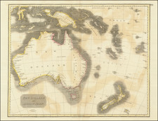
First Map of the Entire Island of Van Diemen's Land-Striking, Rare, Separately-Issued Chart of Tasmania from the Baudin Expedition
Detailed chart of the island of Tasmania as surveyed during the Baudin expedition and published by expedition member Louis Claude Desaulses de Freycinet, the first to show the entire island and to focus exclusively on the island. It was included in his celebrated and very rare hydrographic atlas, part of the official account of the voyage. This example is special in that it is a separately-issued sheet from the French Hydrographic Office, sold for 3 francs.
The chart shows the entirety of Van Diemen's Land as it was known in 1808. It was the second chart in the hydrographic atlas and intended as a guide to the eight larger-scale charts of Tasmania's coastline which follow. When this atlas was published, it was still only recently known that Tasmania was an island and the novelty of that information explains the detailed coverage of the island in the atlas-establishing its coastline was one of the major achievements of Baudin's voyage. This is the first map to show the entire island and its outline is substantially more complete than previous charts that include the island, for example that of Cook in 1777 or that of Flinders published in 1801.
The chart is powerful in its simplicity; it highlights the coasts of the island, with soundings in the northwest, near the Hunter Islands, and along the eastern coast. The high number of French toponyms on the east coast reflect the presence of the Baudin expedition's ships, but also those of fellow French explorer Antoine Bruni d'Entrecasteaux. The voyage of Tasman, the European discoverer of Van Diemen's Land, is also referenced in the southwest, with "Is. de Witt (de Tasman)."
The title, in an oval cartouche at the center top of the chart, explains that the chart was drafted by Freycinet. It also mentions the names of the ships involved in taking observations for the chart, which include the 29-foot Casaurina, which was bought so that its commander, Freycinet himself, could take careful inshore measurements. The Baudin expedition had two larger ships, the aptly-named Geographe and the Naturaliste.
The chart contains little adornment besides the cartouche; it was meant to simply and clearly communicate the extensive survey undertaken by the French despite the presence of another British voyage, that of the British Royal Naval officer Matthew Flinders, which was also surveying Australia in the first years of the nineteenth century.
European exploration of Van Diemen's Land
This is one of the earliest and the most complete chart of the entirety of Van Diemen's Land to have been published. The region had already been visited by several European expeditions, all trying to accurately portray the islands and waterways.
Abel Tasman was sent by the Governor-General of the Dutch East Indies, Anthony van Diemen, to seek new lands, resources, and trading opportunities to the south of Australia. In two expeditions in the early 1640s, Tasman sailed in the waters surrounding the continent. His crew were the first Europeans to sight New Zealand, Tonga, and the Fiji Islands. Also, they were the first to visit Van Diemen's Land.
After sailing widely in the far southern Indian Ocean, Tasman found previously unknown land on November 24, 1642. This shore was named for the governor and Tasman's ships charted the southern coast. However, Tasman's officers decided not to tarry on the newly found territory and instead struck out farther east, toward New Zealand. He therefore did not discover the strait between Van Diemen's Land and mainland Australia; it was drawn as a part of the mainland for over a century.
The first detailed surveying of the area was done by Tobias Furneaux, who gives his name to islands in the top right of this chart. Furneaux was one of the first men to circumnavigate the world in both directions. He went round Cape Horn with Samuel Wallis (1766-8) and round the Cape of Good Hope with Cook on his second voyage (1772-5). He was the first European to set foot on Tahiti, where he hoisted the pennant. It was with Cook, however, that he visited New Holland. As commander of the Adventure, Furneaux was separated from his commander and took to surveying the coast south of Botany Bay. He got as far west as Van Diemen's Land and the Furneaux Islands.
Cook sailed to the south of Van Diemen's Land on his third expedition, thus leaving the Bass Strait uncharted. Another near miss happened on Antoine Bruni d'Entrecasteaux's voyage to find out the fate of the celebrated French explorer La Perouse. D'Entrecasteaux left France in October 1791 and arrived off Van Diemen's Land in April 1792. He stayed in the vicinity for five weeks, with his base at Baie de la Recherche, surveying and charting in the south of the island. He returned in 1793 and started a systematic search of the southern coast of Australia, laying claim to first discovery of that area, but was forced to sail for a known port in Van Diemen's Land due to lack of water. If he had continued east, perhaps the Bass Strait would be named for d'Entrecasteaux.
As it is, the strait bears the name of George Bass, but it owes its charting to Flinders. Flinders first came to Australia in 1795 as a young naval officer on a voyage to deliver John Hunter to serve as the Governor of New South Wales. On that voyage he met Bass, the ship's surgeon. Once in Port Jackson, the two men set out on two surveying voyages in two tiny vessels, both named Tom Thumb. This established their reputations as skilled hydrographers and navigators.
In 1798, now Lieutenant Flinders was charged with command of the Norfolk and ordered to sail west of Furneaux's islands to see if a strait did indeed exist, as there were recent rumors from a shipwrecked crew that a strait was a possibility. If confirmed, the discovery of a strait would change the shape of Australia on all maps and cut the voyage to New South Wales short by several crucial days.
Flinders did confirm the suspected passage in 1798-9, when he and Bass circumnavigated Van Diemen's Land. Flinders suggested naming the strait after his good friend, which the Admiralty accepted. He also discovered and named Hunter Island, in the northwest of this chart, after the Governor of New South Wales he had accompanied. Three Hummock Island, nearby, is also a Flinders toponym.
The geographic importance of Van Diemen's Land
The insularity of Van Diemen's Land was an important geographic discovery not only because it shortened travel times, but because the island offered the French an opportunity for a colonial foothold in Australia, thanks to the claims made by d'Entrecasteaux and Baudin. Although Flinders is credited with the discovery of insularity, the Baudin expedition also contributed significantly to the known geographic detail of the island. They especially surveyed Maria Island, the d'Entrecasteaux Channel, as well as the larger Bass Strait, all of which are shown in detail on this chart. Freycinet and the Baudin expedition added especially to knowledge of the eastern coast.
While the Baudin expedition was still sailing in 1803, the governor of New South Wales, Philip King, sent Lieutenant John Bowen to establish a British presence on the east coast of the island. He wanted to stop the French from achieving the colony they so desired. In 1856, the island colony was granted self-government with a representative parliament. It was then that the name officially changed from Van Diemen's Land to Tasmania.
Louis Freycinet and the Baudin Expedition
This chart featured in the rarest of the volumes to come out of the Baudin expedition. When Nicolas Baudin left Le Havre in the Geographe and the Naturaliste in October 1800, he was embarking on a voyage meant to survey the shores of Australia. At this time, the British had established their presence in eastern Australia, but the western and southern portions of the continent remained unexplored and not necessarily claimed by the British. In other words, although ostensibly a scientific expedition, the French were also open to possible overseas expansion if the opportunity arose.
In the Naturaliste, commanded by Captain Hamelin, was Louis Freycinet, then only 21 years old. He had joined the French Navy in 1793 and was accompanied on this voyage by his brother, Louis-Henri, who would go on to become an admiral.
Initially the ships, sometimes separated, made their way north up the western coast of Australia from Cape Leeuwin to Timor. They then went south again, but were separated a second time. Baudin and the Geographe made for Van Diemen's Land and then returned toward the west. En route, they encountered Flinders in the Investigator. Flinders, on his third Australian surveying mission, was heading to Sydney, from where he would begin a clockwise circumnavigation of the Australian continent, the first such voyage to ever do so. Flinders named the place where he and Baudin met Encounter Bay.
Baudin and Hamelin were reunited in Sydney, where both ships had come to recuperate in late 1801. While there, Baudin purchased a 29-foot vessel. He named it Casuarina and placed Freycinet, who had proved himself an adroit hydrographer under Hamelin, in command. With his new charge, Freycinet was to perform inshore surveys.
During the course of 1802, the Geographe and the Casuarina surveyed the southern coast of Australia (the Naturaliste had been sent back to France). They then sailed round the west coast to Timor, then back to Mauritius, where Baudin died. It was also where the Casuarina's career ended, as the ship was abandoned in favor of consolidating the crews on the Geographe. The ship returned home on March 25, 1804.
The publication of the voyage accounts and atlas
This map chronicles the work of the Casaurina and the larger ships and was part of the rare hydrographic atlas published in 1812. Although the French were largely repeating work already done by Matthew Flinders, some of the French toponyms survive today. This is due in large part to the fact that this map was finished before Flinders could produce his own account of his Australian circumnavigation. He had published several charts of his 1798 expedition, which were used by Freycinet in making this chart, but Freycinet's work shows a much larger and more complete area, lending it importance and primacy.
Why did Flinders take so long to publish his own findings, yielding the novelty of publishing the charting of the Australian coastline to the French? Flinders left New Holland in 1803 and arrived in Mauritius to water and repair his leaky vessel on December 15, 1803. Unfortunately, word had reached the French-controlled island only three weeks prior to his arrival that the British had ruptured the fragile Peace of Amiens; the French and British were at war once again. The French governor, General Decaen, detained Flinders after the British officer was not entirely polite. Flinders was kept against his will on the island for six and a half years, returning to England only in October of 1810. Additionally, the French seized his papers, including the ships logs, though they were eventually returned in part.
Freycinet, meanwhile, had returned to France in 1804. Since Baudin had died in Mauritius, the naturalist Francois Peron and Freycinet were directed to prepare for publication the official account of the voyage, with an accompanying atlas. Baudin was not generally well liked by his fellow sailors, a fact borne out by the limited reference made to him or his discoveries in the narrative and maps of the voyage. The French maps also do not recognize the prior claims of first discovery by men like Flinders, in an attempt to give France more prominence. However, Freycinet did likely have access to copies of Flinders' documents seized when he was imprisoned, improving the detail of his charts.
The official account appeared over ten years and in four volumes. The first narrative of the voyage, primarily by Peron, was published in 1807. The second narrative volume was published in 1816 and was written primarily by Freycinet. Peron had died in 1810. The first part of the Atlas, which contained 40 engraved plates, two of them folding, appeared in 1807. The second atlas, was published in 1811 with 14 engraved charts, two of them double-page. These double-page maps include a map of the Australian continent, the first map to show the continent in its entirety and made partially from Flinders' papers.
The map shown here first appeared in the rarest of the volumes prepared by Freycinet, the hydrographic atlas dated 1812, although it was not distributed until 1814. It contained 32 engraved charts, 25 of them double-page. An accompanying text volume was published in 1815, also by Freycinet.
By contrast, Flinders' narrative and atlas of his own account appeared only in 1814, almost a decade after the first maps of the Baudin expedition were published and three years after the completion of this chart.
Freycinet's later career
His publications stemming from the Baudin expedition would have been enough to secure the fame of Louis Freycinet. However, he is perhaps best known today for his second voyage to the Pacific, one he commanded in the Uranie. From 1817 to 1820, Freycinet cruised the Pacific performing experiments and, of course, making detailed charts. He was accompanied by his wife Rose.
Although the Uranie was wrecked in the Falklands on the return journey, the natural historical specimens and geographical notes were saved. They were published in 13 volumes with 4 additional volumes of plates and maps between 1824 and 1844.
The voyage secured Freycinet a place in the Academie des Sciences. He also went on to help found the Paris Geographical Society, the first such group of its kind. Louis Freycinet died in 1841.
Rarity
The hydrographic atlas is the rarest of the Baudin publications, many times rarer than the narrative, and it is seldom on the market. This separately issued print is very rare, especially in such good condition. It would be an important addition to any collection of Tasmania or Australian cartography.
Louis Claude Desaulses de Freycinet (1779-1841) was a French hydrographer and explorer. He joined the French Navy in 1793. In October 1800, at the age of 21, Freycinet set off in the Naturaliste, part of an exploratory expedition to chart Australia. He was accompanied on this voyage by his brother, Louis-Henri, who would go on to become an admiral.
In Sydney, the leader of the expedition, Nicholas Baudin, purchased a 29-foot vessel. He named it Casuarina and placed Freycinet, who had proven himself an adroit hydrographer, in command. With his new charge, Freycinet was to perform inshore surveys. During the course of 1802, the Casuarina charted large portion of the southern coast of Australia.
Freycinet returned to France in 1804. Since Baudin had died in Mauritius, the naturalist Francois Peron and Freycinet were directed to prepare for publication the official account of the voyage, with an accompanying atlas. The official account appeared over ten years and in four volumes. The first narrative of the voyage, primarily by Peron, was published in 1807. The second narrative volume was published in 1816 and was written primarily by Freycinet. Peron had died in 1810. The first part of the Atlas, which contained 40 engraved plates, two of them folding, appeared in 1807. The second atlas, was published in 1811 with 14 engraved charts, two of them double-page. These double-page maps include a map of the Australian continent, the first map to show the continent in its entirety and made partially from Matthew Flinders’ papers.
His publications stemming from the Baudin expedition would have been enough to secure the fame of Louis Freycinet. However, he is perhaps best known today for his second voyage to the Pacific, one he commanded in the Uranie. From 1817 to 1820, Freycinet cruised the Pacific performing experiments and, of course, making detailed charts. He was accompanied by his wife Rose.
Although the Uranie was wrecked in the Falklands on the return journey, the natural historical specimens and geographical notes were saved. They were published in 13 volumes with 4 additional volumes of plates and maps between 1824 and 1844.
The voyage secured Freycinet a place in the Academie des Sciences. He also went on to help found the Paris Geographical Society, the first such group of its kind. Louis Freycinet died in 1841.
![[ Australia called Notasie ou Nouvelle Hollande ] Carte De L'Oceanie Contenant L'Australe, La Polynesie et Les Iles Asiatique . . . 1838](https://storage.googleapis.com/raremaps/img/small/99649.jpg)