|
||

|

|
|

|
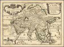
One of the Earliest Maps to Show and Name the Philippines
Rich, dark impression of Matthias Quad's map of Asia. The map shows the entire continent, from the east coast of Africa to the subcontinent to Japan. The land is covered with toponyms; small buildings of varying detail mark settlements and rounded mountains rise in high altitude areas.
Of particular importance are the Philippines, which are easily recognized if not precisely shown; this is one of the first European maps to show and name the island group. The other islands in Southeast Asia are relatively well delineated, reflecting the growing knowledge being gained from the European, particularly Portuguese, trading voyages to the area. Within a decade of this map's publication, the Dutch East India Company and the English equivalent would be thriving enterprises.
The map is a delightful amalgam of cartographic information and conjecture. Japan is a triangular shape that curves to the south. The Korean Peninsula is nowhere to be found. Land in the lower right corner is labeled as Tierra Baixa, a toponym that appeared on several maps during the late-sixteenth century. It is meant to represent the western coast of New Guinea.
The main source for this map is De Jode's map of Asia. The map appeared in the De Jode atlas, Speculum Orbis Terrae, in 1593. Quad (1557-1613), a map publisher based in Cologne, was trained in the Netherlands by Johannes van Doetecum, who also worked with the De Jodes. Quad used many De Jode maps as a base to which he added additional information and decorations.
Quad was best known for his atlases, which were part of the first boom in atlases best characterized by Abraham Ortelius' Theatrum Orbis Terrarum. In 1592, Quad released an atlas of Europe that had 38 maps. He expanded it in 1594 to 50 maps. In 1600, he expanded the collection of maps further still, this time to 82 maps, and called the atlas, Geographisch Handtbuch. All three were small in size, allowing them to compete as cheaper alternatives to the larger atlases of Ortelius, Mercator, and the De Jodes. Quad released one other atlas, in 1608, with 86 maps, the Fascilus Geographicus.
This map appeared in the 1600 atlas, and was published by Johann Bussemachaer (fl. 1580-1613). Quad and Bussemachaer had a long-standing publishing partnership, as the latter also published the 1608 atlas. Bussemachaer wasn't just a publisher, but an engraver in his own right. In Dusseldorf, where he was born, he trained as a copper engraver. Later, he became one of Cologne's most prominent and successful publishers.
Matthias Quad (1557-1613), a map publisher based in Cologne, was trained in the Netherlands by Johannes van Doetecum, who also worked with the De Jodes. Quad used many De Jode maps as a base to which he added additional information and decorations. Quad was best known for his atlases, which were part of the first boom in atlases best characterized by Abraham Ortelius’ Theatrum Orbis Terrarum. In 1592, Quad released an atlas of Europe that had 38 maps. He expanded it in 1594 to 50 maps. In 1600, he expanded the collection of maps further still, this time to 82 maps, and called the atlas, Geographisch Handtbuch. All three were small in size, allowing them to compete as cheaper alternatives to the larger atlases of Ortelius, Mercator, and the De Jodes. Quad released one other atlas, in 1608, with 86 maps, the Fascilus Geographicus.
![[Spectacular Set of Wall Maps of the Continents Dedicated to King Charles II of England, &c.]](https://storage.googleapis.com/raremaps/img/small/93614.jpg)


![Asia [with Australia]](https://storage.googleapis.com/raremaps/img/small/72516.jpg)