


|
||

|

|
|

|
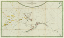
Superb English Map of the Arctic from the Beginning of the Hudson's Bay Company.
A very good example of John Seller's engraved chart of the Canadian Arctic and Hudson Bay; one of three English charts of the region issued in the 1670s, just after the founding of the Hudson's Bay Company. The others being John Thornton's "A New Mapp of the north part of America from Hudson Straights commanly calld the Norwest Passage" (1673) and another map from Seller's Atlas Maritimus "A Chart of ye North part of America, For Hudson's Bay Comonly called ye North West Passage." (1677).
This is a defining and visually compelling map from a pivotal period of English exploration of the Arctic.
Cartography
Seller's map is primarily derived from Joannes van Loon's chart published in 1666. Seller has however substantially modified it in several important respects. In the first state of the map, he correctly rendered James Bay as one bay -- the first time it is so rendered on a map. This new information probably came from the voyage of Charles Bayly who was sent to the area as the first Governor for the HBC. Before they returned home in 1671, Bayly and Thomas Gorst explored the area of James Bay extensively. Seller had connections with the Company that no doubt gave him early access to Bayly's manuscript reports. It is noteworthy and quite puzzling then that in the subsequent states of the map Seller reverted the configuration of James Bay to the accepted -- but at that point disproved -- depiction of an east and west James Bay. It is unclear why Seller reverted this part of the map, but it is possible he had been warned off putting accurate information about the area of the HBC's first permanent settlement on a printed map. Seller also diverges from van Loon by showing Southampton Island in Hudson Bay (mistakenly). He also has a different depiction of the southern end of Greenland.
Interestingly, in the later states of the map the peninsula between the two James Bays bears a label: "Here did Hudson stay all the Winter."
The upper left of the map is adorned with a half-circle polar projection showing the way from the British Isles to Hudson Bay. It is titled "A Polar Projection describing ye Northermost Parts of the World."'
The cartouche in the upper right shows what is presumably a musket-armed explorer of the Hudson's Bay Company.
States
The present example is state 3 of 3 per Burden II 436:
1. 1672-1673 ca. James Bay has the correct configuration, as one bay.
2. 1677 ca. James Bay has been erroneously split into a west and east bay; the toponyms have been modified.
3. 1678 ca. Imprint changed to: "... James/ by John Seller. John Colson./ William Fisher. James Atkinson. and/ John Thornton."
Burden records only five examples of the 3rd state: JHU, BL, BN, and 2 examples in private American collections.
John Seller
John Seller (1627 ca-1697) led a truly fascinating life. He was the son of a cordwainer from Wapping, London. He apprenticed as an instrument maker and became a Freeman of the Merchant Taylor's Company on 25 October 1654.
After the Restoration of Charles II, he was arrested with six other men for plotting against the King. Although it was clear that Seller was not at all involved in the plot, he spent several months in Newgate Prison (while four of the others were executed) before he was finally released on bail and pardoned.
Seller was a towering figure of English cartography and key pioneer of modern mapmaking in a variety of disciplines. In the early 1670s, he set about to break the near-monopoly enjoyed by the Dutch in sea chart publication. His production of the Atlas Maritimus or a Book of Charts Describeing the Sea Coasts . . . of the World (1675), marked a watershed moment in the development of hydrography in Britain. He concurrently worked on the first parts of The English Pilot, including the charts of the Northern and Southern navigation, however financial constraints prevented him from completing the project. This endeavor was subsequently taken up by John Thornton, and later the firm of Mount & Page, who resolutely gave London a leading place in the sea chart trade.
John Thornton
John Thornton (1641-1708) was a chartmaker and publisher and along with John Seller, was the most important figure in English cartography during its ascendency in the latter 17th century. Thornton first learned to draft manuscript charts as an apprentice to John Burston and soon became a leading member of the 'Thames School' of maritime chartmakers. The Thames School was noted for incorporating the latest overseas discoveries by London mariners into beautifully drafted manuscript charts but their influence was limited as they initially published very little of their work.
By the 1660s Thornton set out to change this and, in cooperation with John Seller and William Fisher, began to publish charts and atlases. However, Thornton proved to be the only Thames School alumnus who could make a financial success of publishing. His stock rose rapidly in rarified London circles and he was appointed to be the Official Cartographer to the English East India Company (EIC) and cartographer in ordinary to the Hudson's Bay Company. He also had a privileged relationship with the Lords of Trade, the official body which oversaw England's colonies in North America and the West Indies, which yielded access to important manuscripts.
Thornton issued several groundbreaking maps of North America in the 1670s and early 1680s and published The English Pilot, Fourth Book (1689), the first English sea atlas dedicated to Americas. This was followed by The English Pilot, Third Book (1703), the first English sea atlas of African and Asian navigation. Thornton's charts, with their progressive sources and elegant signature style, are today prized as amongst the most important maps of their era.
John Seller was one of the most notable map and instrument makers in England in the late-seventeenth century. He was especially known for the sea charts, many of which featured in his influential English Pilot and Atlas Maritimus. Seller was born in London in 1632. His father was a cordwainer and John was apprenticed to Edward Lowe, of the Merchant Taylors’ Company. He was made free of that company in 1654. Later, he also was made a brother of the Clockmakers’ Company, which housed several instrument makers. He started business as a compass maker but expanded his offering to include navigational instruments and charts.
Seller’s career was halted temporarily, and fantastically, when he was tried for high treason in 1662. He was accused of involvement in a plot led by Thomas Tonge. While Seller likely only unwisely repeated rumors, he was convicted. The other conspirators, who did admit some degree of guilt, were executed, but Seller maintained his innocence and, via insistent petitions, he eventually secured his release from Newgate Prison.
This episode did not seem to slow Seller’s rise too much, however. Seller was granted a royal license to publish English-language maritime atlases. This gave him a near-monopoly and led to his being named hydrographer to the King in 1671. Although the point of the project was to produce English charts of Dutch dominance and bias, Seller ended up using many Dutch plates as his base material. The first volume of The English Pilot was published in 1671, followed by more volumes as well as The Coating Pilot (1672) and the Atlas Maritimus (1675). Seller was commercially successful, but some of his projects required further support. The English Pilot was eventually taken over by John Thornton and William Fisher, for example, and his proposed English atlas only produced maps of six counties.
Seller’s sons, John and Jeremiah, followed in their father’s profession. Seller also apprenticed several promising young men, including Charles Price, with whom his sons partnered. Through Price, Seller can be seen as the founding figure of an important group of London mapmakers that included Price, John Senex, Emanuel Bowen, Thomas Kitchin, and Thomas Jefferys.
John Thornton was a respected and prominent chartmaker in London in the latter part of the seventeenth century. He was one of the final members of the Thames School of chartmakers and served as the hydrographer to the Hudson's Bay Company and the East India Company. He produced a large variety of printed charts, maps, and atlases in his career, but he was also a renowned manuscript chart maker. Born in London in 1641, he was apprenticed in the Drapers Company to a chartmaker, John Burston. After being made free of the company (1665), he was part of the combine that took over John Seller’ English Pilot in 1677. Thornton was trusted by the naval and navigational establishment of the day; one of his clients was Samuel Pepys, naval administrator and diarist. Thornton died in 1708, leaving his stock to his son, Samuel, who carried on the business.
Samuel, born in ca. 1665, also had apprenticed in the Drapers Company and was made free a year after his father’s death. He continued the business until 1715, when he died. His stock then passed to Richard Mount and Thomas Page.
![[ Aurora Borealis ] Karte der Geographischen Verbreitung des Nordlichtes. Von H. Fritz](https://storage.googleapis.com/raremaps/img/small/98483.jpg)
![[Vancouver] Fraser River and Burrard Inlet](https://storage.googleapis.com/raremaps/img/small/68029.jpg)
![[East Coast of Prince Edward Island - Rollo Bay to Wood Islands]](https://storage.googleapis.com/raremaps/img/small/62849.jpg)
