|
||

|

|
|

|
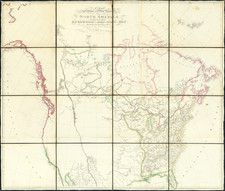
An Early Jedidiah Smith Map
Fine map of North America, with several early important notes in the American West and Texas, published by Tardieu, who is listed as a member of the Central Commission of the French Royal Geographical Society.
In Texas, the location of St. Felipe de Austin and Nashville are shown. Nashville, on the Brazos River, was the primary settlement in Sterling Robertson's Empressario Land Grant in Texas and was surveyed in the Fall of 1835, suggesting that this map was likely published in 1836, but prior to Texas declaring its Independence.
In Oregon Territory and the area just to the north in British Columbia then claimed by the Americans, a number of early Forts are shown, including:
- Ft. Astoria or Clatsop
- Ft. Vancouver
- Ft. Nez Perces
- Ft Lengley
- Ft. Alexandre
- Ft. Thomson
In California and the Southwest, a number of mythical rivers are shown, including two rivers feeding the Rio Colorado entitled R. Amarillo ou Seeds Keeder and R. Piramidas Sulfureas. A number of early Indian Tribes appear in the region, as do some of the remnant of the apocryphal rivers from the earlier part of the century., flowing from Utah to San Francisco Bay.
"Seeds Keeder" was the name used by Jedediah Smith to identify the Green River. The following passage from Smith's expedition in 1826 describes the Seeds Keeder River:
I followed Adams River two days travel further, where it empties into the Seeds Keeder," which I crossed and went a south course down it, through a barren, rockey and mountainous country. In this river are many shoals and rapids. Further down, a valley opens, from five to fifteen miles in width. The land on the river bank is furtile and timbered. I here found another tribe of Indians, who call themselves 'Ammuchiebes." They cultivate the soil and raise corn, beans, pumpkins and mellons in abundance, and also a little Wheat and cotton. I was now nearly destitute of horses, and had learned what it was to do without food. I therefore concluded to remain here fifteen days, to recruit my men; and in the meantime, succeeded in changing my few remaining horses, and was enabled to purchase others, from a party of runaway Indians, who had stolen from the Spainards. I here obtained some information regarding the Spanish country-obtained two guides-recrossed the Seeds Keeder, and traveled a west course fifteen days over a country of complete barrens, and frequently travelling from morning until night without water. Crossed a salt plain eight miles wide and twenty long. On the surface of the ground is a crust of white salt, underneath is a layer of yellow sand, and beneath the sand a few inches, the salt again appears. The river Seeds Keeder, I have since learned, empties itself in to the Gulf of California, about 80 miles from the Ammuchiebes and is there called the Collerado.
The Smith appearance suggests that the map was issued shortly after A.H. Brue's map of Mexico, published in 1834, which is credited as the first map to report this information. The Nashville appearance and the failure to show the Republic of Texas suggests that the map was issued in late 1835 or early 1836.
Rarity
The map is very rare. This is the first example we have ever seen.
Ambroise Tardieu was an important French cartographer and engraver.
He produced a number of excellent large format maps, including a revised edition of Aaron Arrowsmith's 4-sheet map of the United States. T
Tardieu came from a family boasting a number of fine engravers, and was trained from an early age by his uncle, Pierre Alexandre Tardieu (1756–1844), a leading French engraver. Showing considerable talent in this field, Ambroise persevered and became a celebrated engraver of portraits. In addition he was appointed as geographical engraver for the French government, for which he received a small stipend. In order to eke out this meagre wage, he began to trade in prints, books and maps. He is remembered for more than 800 portraits engraved through his career, many depicting scientists of the period.
Tardieu published a number of atlases, one of which appeared in 1842 and was titled Atlas universel de geographie, ancienne et moderne/dresse par Ambroise Tardieu pour l'intelligence de la Geographie universelle par Malte-Brun.
![[ Exceptional original hand-color with highlights in gold ] Typus Aspectuum Oppositionum Et Coniunctionum Etz In Planetis](https://storage.googleapis.com/raremaps/img/small/81866.jpg)
![[ Southern California Water Explorations ] Topographical Sketch showing the Outward and Inward Route of A Party, while examining the practicability of a Diversion of the Colorado River for Purposes of Irrigation under the Command of 1st Lieut. Eric Bergland Corps of Engineers, U.S. Army 1875](https://storage.googleapis.com/raremaps/img/small/98208.jpg)