|
||

|

|
|

|
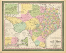
One of the rarest and most important of maps of Texas, and a foundation map for all future Texas cartography.
Jacob de Cordova was a land developer in Texas following its annexation by the United States in 1845. De Cordova and Robert Creuzbaur, working with the General Land Office, compiled from the latest surveys on a scale larger than any prior map of Texas. First issued in 1849, the map was one of the first major cartographic productions after Texas annexation into the US to be based upon the records of the General Land Office.
De Cordova was one of the earliest Jewish settlers in Texas. During the War for Texas independence, he supplied goods from New Orleans, before settling in Galveston in 1837. He quickly took to his adopted homeland, adding several Indian dialects to the 5 languages which he spoke prior to his arrival. After serving a term in the Texas House of Representatives, De Cordova settled in Austin, where he and his brother published the Texas Herald.
Anticipating a land boom in Texas following the Mexican War, he began speculating in land and for the next 30 years, he actively promoted immigration to Texas, which included promotional tours of the United States and Europe. As part of this campaign, he produced his first map of Texas in 1849. Sam Houston persuaded Congress to purchase 500 copies of the 1849 edition, arguing with Jefferson Davis in support of the quality of the map and character of De Cordova during the appropriations process on the floor of the Senate. From 1849 to 1854, De Cordova published the map himself, before assigning the rights to J.H. Colton, who published the map from 1856 onward.
This present edition of the map captures Texas on the eve of Secession.
The map is also the third state to includes railroad lines in Texas, each with progressively more and different information. The present map shows lines being built in and around Houston, extending to Galveston, Richmond, and the Washington area. A railroad line is also shown extending eastward from Marshall in Harrison County. By contrast, in the 1857 edition, the Marshall Railroad line is not shown and the line extending northwest from Houston goes to Rock Island and then to Washington, with a second line headed toward Washington directly, but falling well short of extending the full distance. The 1856, which is the first to show a rail line in Texas, shows only the railroad between Richmond and Houston.
Provenance: James Williams (signature on verso).
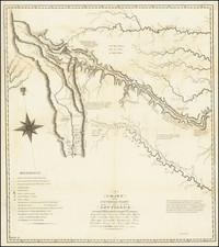
![[Matagorda Bay: Pictorial Letter Sheet]](https://storage.googleapis.com/raremaps/img/small/40810.jpg)
![[Early Texas Colony] 2eme Vue d'Aigleville, Colonie du Texas ou Champ d'Asile](https://storage.googleapis.com/raremaps/img/small/90926.jpg)