|
||

|

|
|

|
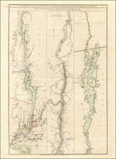
A Franklin Rarity -- Separately Published Official Chart Illustrating the First American Attempt to Find Franklin's Lost Polar Expedition
Rare separately published US Hydrographical Office chart reporting the details of the First American Expedition to search for Sir John Frankin -- the earliest known printed accounting of the so-called First Grinnell Expedition in 1850-51, compiled under the direction of Matthew Fontaine Maury.
Serving as the catalyst for the founding of the American Geographical Society, the expedition was not only an exemplar of endurance and persistence, it also resulted in new geographic discoveries, shaded blue on this chart. These blue areas were to be disputed by the British. Most significantly, the American expedition, along with several British ships also searching for Franklin, located a vital clue in Franklin's mystery: Beechy Island.
The chart details the tracks of the First Grinnell Expedition of 1850-51 and new discoveries of land made by the expedition. As a manuscript note on the back explains, the voyage was the first "American Arctic Expedition in Search of Sir John Franklin." This chart would seem to be the earliest publication to stem from the expedition, which found the most significant evidence of Franklin's to that date, the encampment and graves on Beechy Island. The chart also shows the American side of a geographic dispute fueled by dueling geographic names and features as reported by Edwin Jesse De Haven (1816-1865), of the American expedition, and William Penny (1809-1892), a British whaler and explorer.
The chart was constructed by Maury utilzing information from three British Admiralty charts, then the best navigational charts in the world and adding to it the observations made by the Expedition and a detailed account of its tracks. The chart's compiler, Passed Midshipman George P. Welsh (d.1860), who worked under the famed oceanographer Lieutenant Matthew Fontaine Maury (1806-1873), wanted to show the tracks of the American ships as they ventured up the coast of Greenland, across Baffin Bay, up the Wellington Channel, and then, adrift in pack ice (as denoted by a jagged line), back into Baffin Bay and the Davis Strait before regaining open water and returning up the Greenland coast before the decision was made to return to New York.
The Two States of the Chart
This rare chart most likely dates to late 1851, when it was first issued by the US Hydrographical Office. De Haven sent a report to the Secretary of the Navy on October 4, 1851, and the chart was compiled and published quickly thereafter based on that information. A further clue is that the chart lists Commodore Lewis Warrington as the Chief of the Bureau of Ordnance and Hydrography. Warrington died October 12, 1851, only days after the return of De Haven and his ships. The early date makes this one of the very first published records of the voyage, America's first contribution to the Franklin search.
Based upon our review of the surviving examples, it appears there were two separate issues of the chart. The first issue, as offered here, was made directly by the US Hydrographical Office, at the time of the chart's original creation in late 1851 or early 1852. This chart can be identified by its having been printed on thin paper and the simple blue coloring added to the chart.
The second state of the chart was issued on thick paper by Disturnell & Schroeter of New York. In addition to the thicker paper, the firm seems to have created a pastedown label which was intended to cover up the Sherman & Smith engravers notice from the original printing, added additional color to the map and added in manuscript significant additional details in the ,most northern and western parts of the map, apparently drawn from the Second Grinnell Expedition, along with the tracks of the second Grinnell Expedition and details showing the discoveries of 4 expeditions:
- De Haven's Discoveries, 1850
- William Penny's Discoveries, 1851
- Edward Augustus Inglefield's Discoveries 1852
- William Kennedy's Discoveries 1851-52
Both copies of the chart in the collection of the American Geographical Society (the sponsor of the Grinnell Expeditions) include these annotations. The copy of the chart in the Yale-Beinecke collection is on heavy paper, with the blue shading only.
The Search for the Northwest Passage, the search for John Franklin
The chart shows the extent of Arctic exploration to date, a region that had fascinated Europeans for centuries due to the obsession with finding a Northwest Passage to China. Early expeditions, such as those led by Martin Frobisher and John Davis, are remembered via features like the Davis Strait and the Frobisher Strait (later discovered to be a bay). Eighteenth-century attempts to break through the ice are also referenced, such as Wager Inlet. This feature was named for naval officer and administrator Sir Charles Wager by Christopher Middleton during an early 1740s expedition to see if the inlet, then thought to be a river, extended west to the Pacific.
More recent voyages are also evident, reflecting the nineteenth-century obsession with polar exploration by states and the public alike. To the west is Boothia, discovered by John Ross (1777-1856) in 1830. This was Ross' second voyage to the Arctic. On the first, as commander of a Royal Navy expedition in 1818, Ross sailed with his second in command William Edward Parry (1790-1855), another famous Arctic explorer. Parry eventually discovered the axis of the Northwest Passage, to Ross' shame, and Ross set out in 1829 on a privately-funded expedition to redeem his reputation. He spent his first winter in the Gulf of Boothia. He was also accompanied by his nephew, John Clark Ross, who became the first European to reach the Magnetic North Pole during the voyage. Later, he would lead an Antarctic voyage and also searched for Franklin.
John Franklin (1786-1847) was a contemporary of Ross and Parry. As a young officer, he served on the HMS Bellerophon during the Battle of Trafalgar, an experience that left him somewhat deaf. In 1818, he accompanied Captain Buchan on an expedition meant to reach the North Pole via Spitsbergen. In 1819, Franklin led his first overland expedition to the Arctic to chart the northern coasts of North America. In 1825, and despite the privation suffered on the first overland expedition, Franklin again set out in command of an overland expedition. Eventually Franklin and his fellow, Richardson, charted over 1000 miles of North American coastline.
All of these experiences prepared Franklin for his most famous voyage, to seek the Northwest Passage. Franklin set out in Terror and Erebus on May 19, 1845. On July 26, a whaling vessel sighted the ships off of Baffin Island. That was the last the ships or the men were seen. By 1847, the first of the search parties were dispatched to find Franklin and his crew.
The First Grinnell Expedition & The American Geographical Society
The First Grinnell Expedition of 1850 was the first American effort, financed by shipping magnate Henry Grinnell (1799-1874), to determine the fate of Franklin. Grinnell had become interested in the voyage and was a correspondent of Lady Jane Franklin, John's wife who led the search for her husband for decades.
Grinnell bought two ships, the Rescue and the Advance, and loaned them to the United States Navy, who agreed to man and plan the voyage. Led by Lieutenant De Haven, who had served on U.S. Ex. Ex., the crew ranged across the Barrow Strait, where Franklin had supposedly been. While sailing, they encountered three British expeditions which were also searching. These included ships commanded by John Clark Ross and Penney, whaler and friend of Lady Franklin.
At Cape Riley, where the Wellington Channel departs Barrow Strait to the north, the Americans, working in concert with the British, found stone tent supports, clothing, and salt beef casings. They had located a previously unknown camp that could only have belonged to Franklin.
Next, the ships went to Beechy Island where, in August 1850, they found an encampment with newspapers from 1844, tinned food with British labels, and other artifacts. Search parties then discovered the graves of three men, Marine W. Braine, Able Seaman John Hartnell, and Stoker John Torrington, whose grave marker said he died on board Terror. The American-British crews had located Franklin's wintering spot for 1845-6. This was the first indication the searchers had that Franklin's men still had a ship to this point. It was the largest and most significant Franklin find to date.
It was the search for Franklin that also catalyzed the formation of The American Geographical Society. Founded by a group of 31 wealthy philanthropists, historians, publishers and editors, the original founders included George Folsom, Henry Grinnell, Henry Varnum Poor, Hiram Barney, Alexander Isaac Cotheal, Henry Evelyn Pierrepont, S. De Witt Bloodgood, John Romeyn Brodhead, Joshua Leavitt and Archibald Russell.
The founders held a joint interest in polar exploration, and readily organized the AGS upon the request of Lady Franklin to search for her husband and his voyagers lost in the Polar Franklin Expedition. In September 1851, the committee formed to draft a constitution. On October 9, this committee undertook the constitution at a meeting held in the Geographical and Statistical Library in New York City. The Society was not fully established until December 7, 1854, under a charter granted by legislator of the State of New York.
A geographic argument
After De Haven's return in late September 1851, he was dismayed to learn that British Admiralty charts had renamed the land he had discovered and named for Henry Grinnell as [Prince] Albert Land. Penny, who visited the area eight months after De Haven, had made conflicting sketches of the coasts of Wellington's Channel and Grinnell, or Albert, Land. He publicized these discoveries in the Illustrated London News in mid-September 1851, followed by n chart appended to his report to the Arctic Committee of the British Admiralty, dated September 23, 1851.
The appropriation of De Haven's discoveries caused a few American feathers to be ruffled, as explained in "Remarks on the English Maps of Arctic Discoveries, in 1850 and 1851, made at the Ordinary Meeting of the National Institute, Washington, in May, 1852." The paper was written by Peter Force (1790-1868), historian, editor, and former mayor of Washington D.C.
In the published paper, Force includes a map comparing De Haven's discoveries of September 1850 as compared to those of Penny and his fellows in the summer of 1851. Those attributed to De Haven closely mirror the blue sections on this chart, suggesting again a publication date of at latest May 1852, but more likely October 1851, when De Haven made his report to the United States Navy.
Grinnell and the continuing search
The Beechy Island discovery only spurred interest in Franklin's fate. In 1853, Grinnell funded a second expedition, this one led by a doctor who had sailed on the first expedition, Elisha Kent Kane. Kane had also published the account of the first voyage, in 1854. Kane's voyage made no further Franklin discoveries, although it sailed farther north than any previous expedition and charted Grinnell Land. The crew had to abandon ship in the ice.
In 1856, Grinnell helped to convince the US government to restore the HMS Resolute. The Resolute had been purpose-built by the Royal Navy for Arctic exploration, and, under the command of Captain Horatio Thomas Austin, assisted in the discovery of the Beechy Island Camp alongside Grinnell's ships. However, on a subsequent Franklin search mission, it was abandoned in the ice in 1854. An American whaler later recovered the ship and brought it to New London, Connecticut.
With Grinnell's encouragement, the exploration ship was repaired and returned to Queen Victoria in December 1856. Resolute was decommissioned in 1879 and broken up for timber. Some of these timbers were used to make at least three desks. One of these has been used by numerous Presidents of the United States, a gift from Great Britain. Another, a lady's writing desk, was presented to Grinnell's widow in recognition of his dedication to the search for Franklin.
While the Resolute was locked in the ice and then returned to service, the expeditions looking for Franklin continued. In 1854, John Rae, overland explorer, heard from the Inuit of a place where thirty white men had starved, and possibly resorted to cannibalism. Rae bought several Franklin artifacts from these local people and brought them back to England, where they were displayed to the public, as were relics brought from Beechy Island.
In 1859, yet another expedition, this one led by Francis Leopold McClintock, encountered Inuit who told the same tale of a crew of white men who had perished near King William's Island, shown here as an incomplete outline of an island southwest of Boothia. On May 24, 1859, the searchers found a body, confirmed as one of Franklin's crew by his clothes. Another party, led by Lieutenant W. R. Hobson, located the Victory Point Record, the only written document recovered from the Franklin expedition. The document explained that Franklin had died June 11, 1847, while the rest of his men tried to journey south. They abandoned their ships to the ice in April 1848. Despite their efforts, these survivors also perished; all 128 members of the expedition were casualties of the greatest geographical search in history, the seeking of the Northwest Passage.
Recent discoveries and persistent questions
Overall, nearly forty expeditions sought Franklin from 1847 to 1860. The search did not end there, however. In 2014, a team led by Parks Canada located the wreck of the Erebus, south of King William Island in the Queen Maud Gulf. In 2016, the Arctic Research Foundation led an expedition that located the wreck of Terror in Terror Bay, on the southern coast of King William Island. It was found in the Simpson Strait, which is labeled on this chart.
Inuit oral history was crucial to locating the wrecks, just as it was important to discoveries in the nineteenth century. The fact that Terror was located in Terror Bay, where many bones of Franklin's men were also scattered, seems to indicate that the ship was not abandoned after all. Did the ships drift to their final resting places, locked in by ice, or did they sail? How long did the men last? Why did they leave no other written records? The more discoveries that are made, the deeper the mystery of Franklin becomes and this chart captures a crucial American contribution to that mystery.
Rarity
The map is rare. It appears in Henry Stevens' Catalogue of the American Maps In the British Museum at Christmas 1856 (p.3), which dates the map to 1851(?). Phillips' List of Maps of America in the Library of Congress, lists the map on page 118, but notes the printer as "Disturnell & Schroeder, 1853," apparently a later edition of the map.
Worldcat lists copies at Yale (printed on heavier paper), Brown University, University of Wisconsin-Madison, Dartmouth, the Boston Athenaeum, UC Berkeley, and the University of Amsterdam. We locate only a single copy of the map coming to market more than one hundred years ago in the Edward Everett Hale Collection Catalogue (1911), item #408-36.
Peter Force, “Remarks on the English Maps of Arctic Discoveries, in 1850 and 1851, made at the Ordinary Meeting of the National Institute, Washington, in May, 1852,” (Washington: R. A. Waters, 1852).
Elisha Kent Kane, The U.S. Grinnell Expedition in Search of Sir John Franklin: a Personal Narrative (Harper & Brothers, 1854).
L. H. Neatby, “DE HAVEN, EDWIN JESSE,” in Dictionary of Canadian Biography, vol. 9, University of Toronto/Université Laval, 2003–, accessed November 14, 2017, http://www.biographi.ca/en/bio/de_haven_edwin_jesse_9E.html.
W. Gillies Ross, “The Type and Number of Expeditions in the Franklin Search 1847-1859” Arctic 55, no. 1 (2002): 57-69.
Paul Watson, Ice Ghosts: The Epic Hunt for the Lost Franklin Expedition (W. W. Norton, 2017).
Glyndwr Williams, Voyages of Delusion: The Search for the Northwest Passage in the Age of Reason (HarperCollins, 2002).
![[ Exceptional original hand-color with highlights in gold ] Typus Aspectuum Oppositionum Et Coniunctionum Etz In Planetis](https://storage.googleapis.com/raremaps/img/small/81866.jpg)
![[Unique Extra-Illustrated Example!] Carte Nouvelle Contenant La Partie d'Amerique La Plus Septentrionale, . . . Le Canada ou Nouvelle France, La Nouvelle Ecosse, La Nouvelle Angleterre, Les Nouveau Pais Bas, La Pensylvanie . . . Et Jle. de Terre Neuve . . .](https://storage.googleapis.com/raremaps/img/small/47720.jpg)