|
||

|

|
|

|
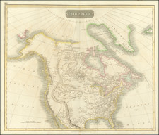
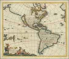
The First Americans Came To America via the Lost Continent of Atlantis?—Rare Italian Map from Work on the Origins of Americans Utilizing The Theories of Philippe Buache
Very rare, Italian example of Buache’s theoretical geographic ideas on transoceanic mountain ranges, as utilized by Count Giovanni Rinaldo Carli to argue for his theory on the origins of Native Americans.
The map was published as part of Carli's Delle lettere americane (Cosmopoli [Cremona], 1780), which entered into the eighteenth-century debate on the origins of indigenous Americans. It argued that they may have come from the lost continent of Atlantis. The map is one of the first Italian-language items to share Buache's work.
The map is actually three maps in one. First, the largest portion (no 1) portrays the geographic relationship between Africa and South America. Below (no 2) is a cross section of the sea floor showing underground mountains, some of which surface and are islands. Third, in the lower right (no 3), is a reduced version of a map of the North Pacific, which Buache would develop into one of his more controversial maps in the early 1750s.
The title explains these smaller sections. Translated from Italian, it reads:
Portion [limited part] of the map presented to the Academy of Science of Paris in the years 1737 and 1752 by Mr Buache.
No 1 represents the situation of the shoals and [sea] floor between Africa and America
No 2 cross-section of the underwater ground
No 3 the eastern position of Asia, and the western of America
Numbers 1 and 2 were originally part of Buache’s “Carte de la Partie de l’Ocean vers l’Equateur entre les Cotes d’Afrique et d’Amerique, drawn by Buache in 1737 to illustrate the underwater mountains he thought connected the two continents. The proof for Buache lay in islands like Noronha, shown peaking above the water line in no 2, which was the top of a peak in the aqueous mountains.
The third part of the map, the map of the North Pacific, is based on Buache and Joseph Nicholas De L’Isle’s controversial map of the region published in 1752. This simplified version shows the discoveries of the “Russi”, or Russians, which approximately outline the peninsula and archipelago that trails west from Alaska’s mainland. This is a reference to the expeditions of Vitus Behring (1728-30, 1733-43).
Interestingly, Carli has chosen to keep the Strait of Anian, a mythical northwest passage based on a garbled passage from Marco Polo, even though many contemporary geographers had ceased or limited the use of the feature. Additionally, Carli keeps the outlines of a Sea of the West, although it is not labeled here. With their 1752 map, Buache and J.N. De L’Isle had re-introduced the idea of a large inland sea in North America based on a review of Buache’s father-in-law, Guillaume De L’Isle’s, papers. The feature had first appeared on the maps of Johann Baptiste Nolin around 1700, who plagiarized the idea from Guillaume. Guillaume, however, never published the Sea, only theorized about it in his notes.
Together, the three maps are intended to illustrate the possibility of land bridges between continents. Carli was interested in land bridges because he thought that Europe and the Americas were once connected by Atlantis, a continent in the Atlantic Ocean. Atlantis sunk after a comet struck the area, Carli argued, which separated the Americans from Europeans before the development of writing and other technologies.
Philippe Bauche and theoretical geography
Philippe Buache (1700-1773) was one of the most famous French geographers of the eighteenth century, and not just because of the Sea of the West. As mentioned, Buache was married to the daughter of the eminent Guillaume Delisle and worked with his father-in-law, carrying on the business after Guillaume died. Buache gained the title geographe du roi in 1729 and was elected to the Academie des Sciences in the same year.
Buache was a pioneering theoretical geographer interested in demonstrating the interconnectedness of the world’s landmasses. In 1737, Buache drew a bathymetric map of the English Channel and he published it the Academie’s Memoires in 1752. At the top of this map was a cross section scale showing the depths of the Channel and its hidden features, much like the one of the Atlantic shown on this map.
Buache was also interested in watersheds, which he argued were created by interlinked mountain ranges which circled the globe and even ran under the oceans. These mountain ranges provided routes for rivers to flow to the sea. At sea, islands were proof to Buache of mountain ranges which connected the continents. Buache presented this mountain chain idea at the Academie in November 1752.
To prove his case, he used a map of the world on a polar projection which highlighted the mountain ranges and watersheds—it is thought to be one of the first thematic maps. The map would also accompany Buache’s published essay on the subject, An Essay of Physical Geography, wherein it is proposed to present General Views on what may be called the Framework of the Globe, composed of mountain systems that cross seas as well as continents; with some particular remarks on the different basins of the sea, and on its interior configuration (1752). On this map, Buache illustrates the mountains that connect Brazil with West Africa. It shows the undersea topography via a dotted line, a theory also illustrated by the profile below at the bottom (No 2).
The debate over the origins of Americans
Carli took Buache’s ideas and used them in his treatise on the geography and peoples of the Americas, first published in 1780. Carli was an intellectual aristocrat involved in the intellectual movement known as the Enlightenment. He was born at Capo d’Istria, then part of the Republic of Venice and now known as Koper in Slovenia.
At the age on only 24 he was appointed to be professor of astronomy and navigation at the University of Padua, where he also was tasked with superintending the Venetian Navy. After seven years, he resigned so that he could devote himself to studying history and economics. The Emperor Leopold appointed him to be head of his economic council; later he was named privy councilor and then president of finances. Retired, he turned again to research and produced numerous works, including the theoretical geographic work that included this map, Delle Lettere Americane.
In Delle Lettere Americane, Carli was intervening in one of the most contested of eighteenth-century debates: the origin and development of indigenous Americans. Whatever their preferred topic of expertise, Enlightenment philosophes demonstrated a rage for order. The taxonomic organization of species, cultures, and objects was its central goal. However, mere differentiation was not the end point, an overarching, all encompassing system was; placing groups in a sequence, thus constructing such a system, allowed philosophes to not only categorize groups of people, usually by geographic origin, but also to put them within a hierarchy with, unsurprisingly, placed white Europeans at its apex.
Americans, only recently known to Europeans and about whom little was understood by the eighteenth century, posed a particular intellectual conundrum to the philosophes. How did they get to the Americas? How long had they been there? Why had they not developed the same technologies as Europeans? How were they related to Europeans and how did they compare to them? Similarly, what would happen to Europeans in the strange environment of the Americas? Would they develop similarly to those who stayed in Europe?
Several philosophes took on these questions and came to conclusions that are outrageous and even offensive today; however, they do reveal much about Enlightenment thought. The French naturalist the Comte de Buffon argued for a climatic and biological explanation for human differentiation and described racial difference as a consequence of temperature and the effects of physical activity on the human body. According to his theories, the entire New World was inferior in its natural development as compared to the Old World, including its human inhabitants. Based on the number of American species and their size (i.e. only those that Buffon heard about from his base in Paris), he concluded that American nature, and its indigenous people, had degenerated from superior Old World stock, an idea that is known as Degeneracy Theory.
Buffon was not the only philosophe and scientist to believe that climate explained the racial characteristics of indigenous Americans and other peoples as compared to Europeans. Perhaps the most influential believer in a theory of environmental determinism was the Dutch cleric and writer Cornelius de Pauw. In 1768, he combined the ideas of environmental determinism and American exceptionality, concluding that America was behind in its natural development. De Pauw argued that the climate of America degraded not only the indigenous inhabitants of the region, but also Europeans who chose to live there.
The influence of de Pauw and Buffon continued to appear in other publications, including the Histoire philosophique des deux Indies, first published in 1770 by the Abbé Raynal. He concluded that America must be behind Europe somehow, but he did not necessarily ascribe to the environmental determinism of Buffon and de Pauw. While he agreed that the Americans were indeed inferior, he was unsure whether such primitive behavior was a result of “the decay or the infancy of nature.”* Indeed, degeneration versus development as a means to explain the lack of civilization amongst indigenous Americans was a popular debate at the time.
The idea that indigenous Americans represented an earlier state of human development was a popular explanation for their subordinate status during the Enlightenment. William Robertson, like Raynal, discussed both environmental determinism and historical development in his History of America in 1777. He also depended quite heavily on older Spanish sources while eschewing the validity of more contemporary creole sources, much to the dismay of educated creoles in the New World. This was partially due to his conviction that the American environment had degraded the creole mind. Robertson did not stop at a climatic explanation, however. He attributed the weak constitution of indigenous Americans as examples of man closer “to the brute creation.”**
Carli and the origins of Americans
Carli was familiar with all these thinkers and their ideas; indeed, they are heavily cited in his Delle Lettere Americane, which was Carli’s summary of and intervention in the American origins debate. He identified many similarities between ancient Old World cultures and those Europeans had encountered in the Americas, suggesting some contact between them. He concluded that Americans had left the Old World before writing, ironwork, and coinage were developed, which explained why they did not have those technologies. But how did the Americans leave the Old World?
Carli thought that they had migrated across a land bridge—the lost continent of Atlantis. In writing about Atlantis, Carli followed the lead of Jean-Sylvain Bailly, who hypothesized that Atlantis had been located in the Arctic at a time when the temperatures were warmer. Diverging from Bailly, Carli placed the continent in the Atlantic Ocean and argued that the islands that still exist in the Atlantic are the highest mountains peaks of the lost continent, now submerged. According to Carli, Atlantis sunk beneath the waves due to the cataclysmic impact of a giant comet. For support of this part of his theory, Carli turned to Buache’s work on underwater mountain ranges; this map is an illustration of Buache’s theories marshalled to support Carli’s own Atlantis theory.
Rarity
Carli’s creative theories were known to contemporaries, including an appreciative Benjamin Franklin, but they are little known today. This is due, perhaps, to the rarity of this map and the book it was included within. Both Delle Lettere American and this map are very rare on the market. We locate only two examples sold at auction since 1963.
Carli's imaginative use of Buache’s theories, and those of his other colleagues across Enlightenment Europe, offer a new entry point into the discussion of race and geography in the eighteenth century. This map would be of interest to anyone fascinated by early American and European encounters or a collector of Atlantis and lost continent cartography.
* Abbé de Raynal, A philosophical and Political History of the Settlements and Trade of the Europeans in the East and West Indies, 3rd edition, trans. J. O. Justamond, (London: 1798), vol. V. 137.
** William Robertson, The Works of William Robertson, D.D (Dublin: Messrs. Whitestone, et al., 1777), Vol. VI, 320.
Comte de Buffon, translated and edited by John Lyon and Phillip R. Sloan, From Natural History to the
History of Nature: Readings from Buffon and His Critics (Notre Dame, IN: University of Notre Dame Press, 1981).
Jorge Cañizares-Esguerra, How to Write the History of the New World: Histories, Epistemologies, and Identities in the Eighteenth-Century Atlantic World (Stanford: Stanford University Press, 2001), 43, 188.
Cornelius De Pauw, Recherches philosophiques sur les americains (Berlin: George Jacque Decrer, 1769).
George Kish and Philippe Buache, “Early Thematic Mapping: The Work of Philippe Buache,” Imago Mundi 28 (1976): 129-136.
Mary Louise Pratt, Imperial Eyes: Travel Writing and Transculturation (New York: Routledge, 1992).
Abbé de Raynal, Histoire philosophique et politique des éstablissments des Européens dans les Deux Indes, 3rd ed, (Amsterdam: 1774).
William Robertson, The Works of William Robertson, D.D. (Dublin: Messrs. Whitestone, et al., 1777).
![(World Architecture) Сравнительная таблица: вышины главнѣйшихъ памятниковъ на земномъ шарѣ. [Comparative table: heights of the most important monuments on the Earth's Surface.]](https://storage.googleapis.com/raremaps/img/small/95512.jpg)