|
||

|

|
|

|
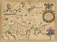
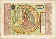
One of the First Maps of Ukraina after the Treaty of Zboriv
Rare early map of Ukraine, divided into provinces, first issued by Jan Jansson in about 1657.
Jansson's map is one of the earliest maps to include the name Ukraine in the title of a printed map, following shortly after the Treaty of Zboriv in 1649, although derived largely from Beauplan's maps.
The map was re-issued by Mose Pitt and again later by Schenk & Valk. However, this first edition by Jansson is quite rare on the market, this being the first example we have ever offered.
The name Ukraine was popularized in the west by Guillaume La Vasseur de Beauplan's Description d'Ukraine, first published in Rouen in 1651 (in an edition of 100 copies) under a different title, with the named changed as above in the 1660 edition and subsequent editions published in French (1661, 1662, 1663) Latin (1662), Dutch (1664), Spanish (1665 and 1672) and English (1680). The work described Ukraine as several provinces of the Kingdom of Poland lying between the borders of Muscovy and the frontiers of Transylvania.
Beauplan, a military engineer, had spent a significant period of time constructing fortresses in the region in the 1630s. In 1650, his map entitled Delineatio Specialis et Accurata Ukrainae, showed the palatinates of Kyiv, Bratslav, Podilia, Volhynia and part of Rus (Pokutia). Another of Beauplan's maps, published in 1648, entitled Delineatio Generalis Camporum Desortum vulgo Ukraina, Cum adjacentibus Provinciis, shows all of the provinces of Poland bordering on the Campus Desertorum or steppe frontier, thereby recognizing the Russian and Polish language references to Ukraine as the "steppe frontier" and leading to the popularization of the name in Western Europe.
The region was later defined by the Zboriv Treaty of 1649, which did not include Rus or Volhnia, but did include Chernihiv. This treaty established the Cossack control of the regions and severed Poland's claims and created the region which would come to be known in the west as the Ukraine.
The map was re-issued by Mose Pitt and again later by Schenk & Valk. However, this first edition by Jansson is quite rare on the market, this being the first example we have ever offered.
Jan Janssonius (also known as Johann or Jan Jansson or Janszoon) (1588-1664) was a renowned geographer and publisher of the seventeenth century, when the Dutch dominated map publishing in Europe. Born in Arnhem, Jan was first exposed to the trade via his father, who was also a bookseller and publisher. In 1612, Jan married the daughter of Jodocus Hondius, who was also a prominent mapmaker and seller. Jonssonius’ first maps date from 1616.
In the 1630s, Janssonius worked with his brother-in-law, Henricus Hondius. Their most successful venture was to reissue the Mercator-Hondius atlas. Jodocus Hondius had acquired the plates to the Mercator atlas, first published in 1595, and added 36 additional maps. After Hondius died in 1612, Henricus took over publication; Janssonius joined the venture in 1633. Eventually, the atlas was renamed the Atlas Novus and then the Atlas Major, by which time it had expanded to eleven volumes. Janssonius is also well known for his volume of English county maps, published in 1646.
Janssonius died in Amsterdam in 1664. His son-in-law, Johannes van Waesbergen, took over his business. Eventually, many of Janssonius’ plates were sold to Gerard Valck and Pieter Schenk, who added their names and continued to reissue the maps.
![[ Jan Mayen Island ] Isola Di Mayen Scoperta l'Anno 1614 . . .](https://storage.googleapis.com/raremaps/img/small/99105.jpg)