This item has been sold, but you can enter your email address to be notified if another example becomes available.


|
||

|

|
|

|
Stock# 53583
Description
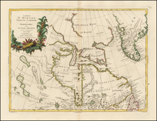
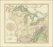
An excellent map of Alaska and the Northwest Coast of America, from Nootka sound to Behring's Strait and showing MacKenzies River.
The map provides an excellent look at the pre-1800 Northwest Coast of America, including conjectural coastlines and a number of early misconceptions. Alaskan Archipelago is referred to The Fox Islands. The map reflects the pre-Vancouver cartography of Cook and Dixon.
An excellent early map, not listed in Wagner, from Malham's Naval Gazetteer.