


|
||

|

|
|

|
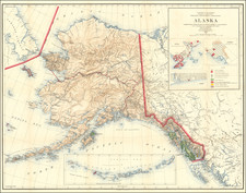
Highly detailed map of Alaska, compiled in the decade after the start of the Alaskan Gold Rush in 1897.
This edition of the map is of note, for its inclusion of early City plans for Sitka, Juneau and Nome.
IN addition to an a very early and detailed look at the mining regions, the map shows District Boundaries, Military, Signal Corps and Cable Stations, Naval and Marin Hospital Reservations, Cities, towns, villages, settlements, US Land Offices, National Forests, Agricultural Experimental Stations and Fish Reserves, Reindeer, Moose and Bird Reserves, Public Schools and Indian Reservations.
The General Land Office (GLO) refers to the independent agency in the United States that was in charge of public domain lands. Created in 1812, it assumed the responsibilities for public domain lands from the United States Department of the Treasury. The Treasury had overseen the survey of the Northwest Territory, but as more area was added to the United States, a new agency was necessary to survey the new lands.
Eventually, the GLO would be responsible for the surveying, platting, and sale of the majority of the land west of the Mississippi, with the exception of Texas. When the Secretary of the Interior was created in 1849, the GLO was placed under its authority. Until the creation of the Forest Service in 1905, the GLO also managed forest lands that had been removed from public domain. In additional to managing the fees and sales of land, the GLO produced maps and plans of the areas and plots they surveyed. In 1946, the GLO merged with the United States Grazing Service to become the Bureau of Land Management.


![[ Pacific Northwest - Northwest Passage ] Limes Occidentis Quivira et Anian. 1597](https://storage.googleapis.com/raremaps/img/small/71207.jpg)