|
||

|

|
|

|
Stock# 53482
Description
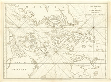
Rare separately issued sea chart of a part of the areas between Singapore Island and the coast of Sumatra, published by the Maritime Safety Agency of Japan shortly after the end of the Second World War.
Major islands shown including Batam, Bulan, Bintan, Sugi, Durian, Rempang, Galang, Citlim, Kaplajernih and Sugibawa.
The map notes that it is based on Dutch and British charts from 1935.
A very unusual chart -- the first we have ever seen.
Condition Description
Minor soiling and signs of use.
![[Southwest Coast fo Myanmar - Myeik and Andaman Sea] Coast of Tenasserim](https://storage.googleapis.com/raremaps/img/small/64783.jpg)