|
||

|

|
|

|
Bullfrog Mining District Boom Town Near Rhyolite, Nevada
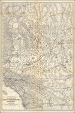
Early plat map of Beatty, Nevada, based upon a field survey conducted by W.O. Owen, between September 16, 1907 and October 27, 1907.
The map shows Beatty shortly after it was laid out in 1905 in connection with the Bullfrog Mining District boom and about 1 year prior to the arrival of the first railroad in Beatty.
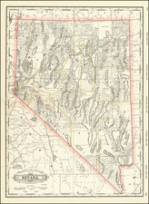
Beatty, Nevada
Beatty is named after "Old Man" Montillus (Montillion) Murray Beatty, a Civil War veteran and miner who bought a ranch along the Amargosa River just north of the future community and became its first postmaster in 1905.
The townsite of Beatty was laid out in 1904 or 1905, after Ernest Alexander "Bob" Montgomery, owner of the Montgomery Shoshone Mine near Rhyolite, decided to build the Montgomery Hotel in Beatty. Montgomery was drawn to the area, known as the Bullfrog Mining District, because of a gold rush that began in 1904 in the Bullfrog Hills west of Beatty.
The Montgomery Hotel in 1905. It was owned by Bob Montgomery, namesake of the Montgomery-Shoshone Mine in nearby Rhyolite.
During Beatty's first year, wagons pulled by teams of horses or mules hauled freight between the Bullfrog district (that included the towns of Rhyolite, Bullfrog, Gold Center, Transvaal, and Springdale) and the nearest railroad, in Las Vegas, and by the middle of 1905, about 1,500 horses were engaged in this business. In October 1906, the Las Vegas and Tonopah Railroad (LV&T) began regular service to Beatty. In April 1907, the Bullfrog Goldfield Railroad (BG) reached the community, and the Tonopah and Tidewater (T&T) line added a third railroad in October 1907.
The LV&T ceased operations in 1918, the BG in 1928, and the T&T in 1940. Until the railroads abandoned their lines, Beatty served as the railhead for many mines in the area, including a fuorsparmine on Bare Mountain, to the east.
Beatty's first newspaper was the Beatty Bullfrog Miner, which began publishing in 1905 and went out of business in 1909. The Rhyolite Herald was the region's most important paper, starting in 1905 and reaching a circulation of 10,000 by 1909. It ceased publication in 1912, and the Beatty area had no newspaper from then until 1947.
The General Land Office (GLO) refers to the independent agency in the United States that was in charge of public domain lands. Created in 1812, it assumed the responsibilities for public domain lands from the United States Department of the Treasury. The Treasury had overseen the survey of the Northwest Territory, but as more area was added to the United States, a new agency was necessary to survey the new lands.
Eventually, the GLO would be responsible for the surveying, platting, and sale of the majority of the land west of the Mississippi, with the exception of Texas. When the Secretary of the Interior was created in 1849, the GLO was placed under its authority. Until the creation of the Forest Service in 1905, the GLO also managed forest lands that had been removed from public domain. In additional to managing the fees and sales of land, the GLO produced maps and plans of the areas and plots they surveyed. In 1946, the GLO merged with the United States Grazing Service to become the Bureau of Land Management.
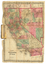
![[Southern California and Southern Nevada] Asher & Adams' California & Nevada, South Portion](https://storage.googleapis.com/raremaps/img/small/92086.jpg)