|
||

|

|
|

|
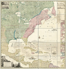
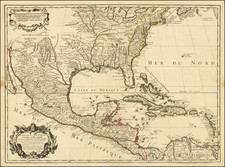
Rare Purcell / Doolittle Map of the Southeast, including the New State of Franklin -- The First Map of the American South Published in America
Nice example of Joseph Purcell's map of the Southern States (and Midwest), which includes an early reference to the New State of Franklin in the center part of North Carolina.
The map is both the first map to show Franklinia (here called the Country of Frankland) and the earliest map of the Southern United States published in America.
The map shows numerous Indian tribes, including the Cherokees, Chicasaws, Chactaws (sic), Upper and Lower Creeks, Muscogees, and Seminolas (sic). "Indiana" appears in the modern West Virginia just below "Seven Ranges and Ohio Company". Other companies above the Ohio include Wabash, New Jersey and Illinois with Army Lands," Gen.r Clark's Grant 150,000 acres" and "Donation Lands from the Commonwealth of Virginia" (which had claimed a wide swath of land including Kentucky to the Mississippi River).
North Carolina extends to the Mississippi including Cumberland Settlements, Nashville and the short-lived "Country of Frankland" Georgia seems to have extinguished the South Carolina bid for a narrow outlet to the Mississippi and appears to be the largest state with Savanna the largest settlement, with islands Cumberland, St. Simon and a few others named.
Purcell's map first appeared in Jeddidiah Morse's American Georgraphy, and in some copies of the August 1788 edition of the American Magazine. The map was re-engraved in London by William Harrison and issued by John Stockdale.
The map is one of the few maps to record the short-lived state of "Franklinia," and the only map to show Franklinia engraved and published in the United States. In the latter part of the 18th century, the settlers in Western North Carolina and Eastern Tennessee decided that because of poor representation in State Government, they needed to form a state of their own. A government was formed and initial organizational meetings conducted, but the breakaway state was quickly quelled by the North Carolina authorities, although not before the State of Franklinia began appearing on a number of English maps during the period. Ben Franklin himself responded that while he was honored by the decision to name a state after him, he was not able to relocate.
The map shows the boundaries between the United States and Spanish Dominions, lines delimiting Indian nations, towns, roads, Indian villages and host of other early details, including counties, Indian trade paths, the Seven Ranges, Ekanfanoka Swamp (Okenfenokee), and Port Vincient (Vincennes), The Ohio Company, New Jersey Company and Illinois Company Lands are shown, as are the Donation Lands of the Commonwealth of Virginia.
The Illinois, Indiana & New Jersey Company land areas appear, as do Army Land, Ohio Company, along with numerous counties in Virginia. Notes regarding Col. Syms Land, the donation grants and Gen. Clark's Grant are also shown. The Spanish Dominions and Louisiana appear east of the Mississippi River, and the region north of Virginia is called the New States, although predating the deliniation of Ohio, Indiana and Illinois. Many other interesting details.