


|
||

|

|
|

|
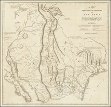
An Early Coast To Coast Map of the United States -- Showing The Republic of Texas
Fine map of the United States from Coast to Coast, also showing the Republic of Texas just one year after its declaration of independence in 1836.
During the 1820s to 1840s, the major French cartographic publishing houses generated some of the most outstanding and historically significant maps of the American west.
This map incorporates remarkable details from the early western explorations of Lewis & Clark, Long, and others, but pre-dating the explorations of John Fremont. The mythical rivers flowing across California, Utah and Nevada are shown, along with both Lake Timpanagos and Lake Teguayo. There is a massive Missouri Territory, dominating the upper Rocky Mountain and Plains regions.. Oregon Territory extends to encompass much of British Columbia.
Many fascinating placenames and mythical geological features in the west. Lots of Indians, early forts, and an early location of the Santa Fe Trail, although with an erroneous route.
Texas is shown as a Republic and includes excellent detail. Arkansas is shown in its widest format, extending to New Mexico.
While we have previously offered the 1838 edition of this map for sale, this is the first time in over 20 years we have seen this edition of the map.
![[United States Independence After The Revolution] A New Map of North America, with the West India Islands, Divided according to the Preliminary Articles of Peace, Signed at Versailles, 20 Jan. 1783, wherein are particularly Distinguished The United States, and the Several Provinces, Governments &ca, which Compose the British Dominions . . . 1783](https://storage.googleapis.com/raremaps/img/small/70734.jpg)

![[The Russian Question] Die Russische Frage. Ein Schauspiel von K. Simonow](https://storage.googleapis.com/raremaps/img/small/83978.jpg)
![[Printed on Linen] Map of Texas and Loyal Colonies Sometimes Referred To As The United States](https://storage.googleapis.com/raremaps/img/small/93363.jpg)
