


|
||

|

|
|

|
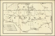
Washington Hood's Map of Western Territory -- With Early Manuscript Additions Naming Early Christian Missions In the Osage, Cherokee, Creek and Choctaw Lands -- Likely Used By An Early Christian Missionary
Important early map of Indian Territory and the first map by Washington Hood, which accompanied Horace Everett's Regulating The Indian Department...
The map extends from Santa Fe, New Mexico and the Yellowstone River in the west, to the Mississippi River, Ft. Smith and Ft. Towson, focuing on the regions occupied by the Indians relocated from the east.
The map includes a number of Christian Missionary Stations, added in a contemporary hand. Given the date of the publication of the map and the towns noted, it is probable that the map was used by one of the commissioners from the American Board of Commissioners for Foreign Missions, which visited the region in 1835 to evaluate the conditions of the Missions which had been established in Osage, Creek and Choctaw country beginning in 1820. Most notably, the person using the map would have had to have been familiar with the Old Hopefield and New Hopefield Missions. As noted below, the original Hopefield Mission was relocated in 1829, following an US-Cherokee Treaty, which gave the lands on which the original Hopefield mission was located to the Cherokees, forcing the Osage residents in the area to relocate to the north.
As many of the missions were closed by 1837 and some of the details are very ephemeral in nature, the information contained on the map is almost certainly contemporary to the printing of the map.
The place names noted below many of the missions then in existence, including:
- Harmony (Christian Mission established in 1821 by Rev. Philip Milledoler of the United Foreign Missionary Society).
- Neosho (Christian Mission established in 1820 by United Foreign Missionary Society)
- Boudinot (Christian Mission established in 1830 by Rev. Nathaniel B. Dodge of the United Foreign Missionary Society, opposite the town of White Hair).
- Old Hopefield (Original Hopefield Christian Mission established in 1823 by Rev. William B. Montgomery and William C. Requa, from the Union Mission. Abandoned by 1829)
- Hopefield (the second or "New Hopefield" was established further north in late 1828, shortly after a US-Cherokee Treaty gave the strip of land shown on this map to the Cherokees, thereby forcing the Mission to be moved north to the location shown on this map as "Hopefield")
- Union (Established in 1820 by Epaphras Chapman of the United Foreign Mission Society. Abandoned by 1836 )
- Park Hill ("home base" for many of the Cherokee after coming from the East on the "Trail of Tears". In 1829, the Park Hill Mission was established. The mission had one of the earliest presses in Oklahoma, the Park Hill Publishing House)
- Dwight (The original Dwight Mission was established in August 1820 on Illinois Bayou, near present-day Russellville, Arkansas, in the Cherokee settlements. It was named after Rev. Timothy Dwight, President of Yale University and an influential member of the American Board of Commissioners for Foreign Missions. In 1828 the Western Cherokees were forced to move out of Arkansas into Indian Territory and Dwight Mission was reestablished on Sallisaw Creek, about thirty miles east of Fort Gibson)
- Fairfield (Originally founded as Mulberry Mission in Pope County, Arkansas Territory, among the Western Cherokees by Dr. Marcus Palmer. The mission was a branch of Dwight Mission, which moved to Indian Territory and was renamed as the Fairfield Mission, when most of the Cherokees were forced to move there from their former homes in the Southeast. In 1832, The mission established a lending library that contained about 150 books)
- Creek Sta. (Lee's Creek Station was a Mission established by American Board of Commissioners for Foreign Missions in the Skin Bayou District, )
- Bok Tuklo (East of Ft. Towson) (Christian Missionary Station in Choctaw Lands, which existed from 1834 to 1836)
- Eagle Town (East of Ft. Towson) (Christian Missionary Station established by Loring S. Williams in 1832)
- Wheelock (East of Ft. Towson) (Christian Missionary Station established by Alfred Wright & Harriet Wright in 1832. The Wheelock Academy operated until 1955)
- Clear Creek (East of Ft. Towson) (Christian Missionary Station in Choctaw Lands from 1833-1837)
- Bethel (Christian Missionary Station in Choctaw Lands, which existed from 1834 to 1837)
- Cedron (south of Prairie House) (Christian Missionary Station in Choctaw Lands as of 1835)
Everett's important report on the Indians and the conditions in the country west of the Missouri, accompanied three House Bills to provide for the organization of the Dept. of Indian Affairs. Wheat described as a highly credible performance, showing the country north of the Red River to Nebraska, and west from the Ozarks to Santa Fe.
Wheat comments that the map "not only showed the various Indian Land assignments, by tribes, west of the Arkansas and Missouri, following McCoy, but its maker used Brown's Santa Fe trail material, and delineated the country to the front wall of the Rockies and Santa Fe with considerable accuracy. The Black Hills run almost north and south. One curious point is that only the Spanish Peaks and "Larimer's" (Laramie) Peak (near the North Fork of the Platte) are shown in the mountains. It is supposed that Isaac McCoy assisted in the making of this map. He had offered advice to Humphrey Phelps and his manuscript map that has been described apparently had consideable "influence."

![[ Oil in the Oklahoma Panhandle ] Map of Cimarron County Oklahoma](https://storage.googleapis.com/raremaps/img/small/102584.jpg)