The item illustrated and described below is sold, but we
have another example in stock. To view the example which
is currently being offered for sale, click the
"View Details" button below.
![[ Venezuela ] A Map of the Caracas By](https://storage.googleapis.com/raremaps/img/small/103834.jpg)


|
||

|

|
|

|
Stock# 52956
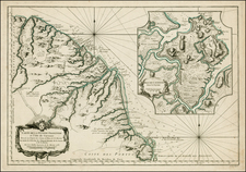
Description
Detailed early map of the coast of Venezuela and contiguous islands (Curacao, Bonaire, Aruba, Tortuga, Trinidad, Tobago, etc.)
The map was issued 3 years after 7 of the 10 provinces of the Captaincy General of Venezuela declared its independence from Spain on July 5, 1811.
More specifically, the map was issued shortly after the campaign of 1813 established the so-called Second Republic, following the retaking of Caracas by an army led by Simon Bolivar on August 6, 1813.
![[ Curacao / Aruba / Bonaire / Venezuela ] Pas-kaart vande zee custen van Venecuela met dye Bylegende Eylanden . . .](https://storage.googleapis.com/raremaps/img/small/99928.jpg)
![[Colombia / Venezuela] Descripcion Del Destricto Del Audiencia Del Nuevo Reino](https://storage.googleapis.com/raremaps/img/small/64974.jpg)