|
||

|

|
|

|
Stock# 52784
Description
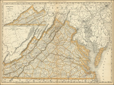
Nice example of the 1814 edition of Carey's map of Virginia, one of the best large format maps of the state to appear in a Commercial Atlas.
The map is attractively hand colored by counties and shows, towns, roads, mountains, rivers, lakes, islands, bays and a host of other early important details.
Carey's General Atlas was first published in 1796, with periodic revisions up to 1818. It was the first American Atlas to be offered for sale with hand coloring on the maps.
Condition Description
Minor offsetting.
![A New and Exact Map of the Dominions of the King of Great Britain on ye Continent of North America . . . [Beaver map]](https://storage.googleapis.com/raremaps/img/small/101277.jpg)