|
||

|

|
|

|
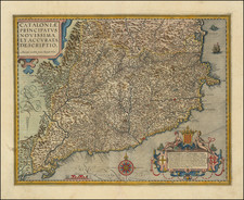
The First and Most Famous Domestically Produced Map of Catalonia of the Eighteenth Century
Fine map of Catalonia by Josef Aparici, the first large format map of Catalonia published by a Catalan. The map was first published in 1720, with a second edition, of which this is an example, in 1769.
The maps shows the highly mountainous nature of the region, with the Pyrenees to the north and the eastern coast of the Iberian Peninsula to the east. The road and river systems are clearly marked, as are the corregiments or corregimientos, a new territorial organization that was the product of the Bourbon repression of Catalonia after the rebellion at the end of the War of Spanish Succession.
The map has charming decorative elements. While the title at the top is simple, an elaborate dedicatory cartouche fills the bottom right corner. It shows a coat of arms and all the trappings of war, signaling the victory of Felipe V in the recent war. Next to the coat of arms is the scale, which is on a banner held by a lion and a dragon. To the east is a simple key and a list of the rectories of the region written on a scroll which is being unfurled by a cherub.
Mapping in Catalonia and the Aparici map
In the sixteenth century, the Generalitat, Catalonia's regional government, did not possess a map of the area over which it ruled. Thus, they requested a "description" from the painter Benet Sanchez Galindo in 1588. Later, in 1596, they paid Miquel Geroni de Salvador for another map. However, Geroni's demands were too high and the Generalitat never acquired his work. They tried again in 1604 with Joan de Grenollacs. None of these manuscript maps survive today.
The first printed map of Catalonia was published in Antwerp in the seventeenth century. The six sheet map, by Joan Baptista Vrients and dedicated to the Generalitat, survives in only one example in the Bibliotheque Nationale in Paris. It was likely this map that Abraham Ortelius and his workers consulted for a reduced map of Catalonia which first featured in a 1602 edition of Theatrum Orbis Terrarum. This was the first of many maps of Catalonia in atlases in the seventeenth and eighteenth centuries; there were over 160 in all, according to the Cartographic Institute of Catalonia.
However, many of these atlas maps were approximate at best and certainly not on a geodetic base. War was the catalyst for more precise and modern methods of mapping, as Catalonia is a border region; this map nods to this border status with the northern section labeled as, "Parte de Langeudoch." The Spanish Empire was stretched financially and focused their mapping on their colonial holdings; therefore, much of the initial surveys of parts of Catalonia came from French military outfits.
In the eighteenth century, Catalonia shifted from map consumer to also being a map producer, if on a small scale. This map is the hallmark of that period of domestic production. Josef Aparici (1653-1731) was a businessman who also worked as a Crown official and, as this map illustrates, as a geographer. While serving under Charles II, Aparici traveled the length and breadth of the region, making notes and calculations as he went.
The War of Spanish Succession, Catalonia, and Aparici
From 1701 to 1714, the Iberian Peninsula was consumed by the War of Spanish Succession. When Charles II died in 1700 with no heir, there were two contenders: Archduke Charles of Austria, a Hapsburg, like Charles II, and the Duke of Anjou, Philippe of Anjou, a Bourbon and the grandson of the powerful King of France, Louis XIV.
Philippe of Anjou ascended to the throne, which angered the Austrian Hapsburg Monarchy and worried the United Provinces and the English, who feared for their trade. In 1701, they declared war on France and Spain; in 1703 Portugal and Savoy also joined the Alliance against the Bourbons.
Philippe, or Felipe V as he was known in Spain, also faced resistance from Catalonia, who joined with England against Spain in 1705. From the stronghold of Barcelona, the allies staged an attack that led to the capture of Aragon and Madrid in 1706. The Cort General of Catalonia declared for the Hapsburg contender, Charles or Carlos III, and the government body excluded Bourbons from holding official posts and taxed them heavily. Barcelona was the seat of the Spanish Hapsburg court, but as the Bourbons advanced, occupying more and more of Catalonia, the city and court's opulence garnered criticism.
By 1711, the only fighting left on the Iberian Peninsula was in Catalonia, Charles III's last stronghold. In April of that year, Holy Roman Emperor Joseph I died, leaving his son Charles III to be proclaimed the new Emperor. This also unseated the power balance of Europe and sped the end of the war. The allied forces agreed to allow Felipe V, the Bourbon, to rule Spain, but only if he agreed to never attempt to lay claim to the French throne. The Bourbons thus secured the Spanish monarchy, a position they still hold today.
Rather than accept the decision of the Allies to end the war, the Catalonians resisted. They came under siege for fourteen months, a situation which ended in defeat for the rebels. In response to the rebellion, the Bourbon administration came down hard on the region: institutions were suppressed, universities shut, violence raged, Hapsburg sympathizers banished, property sequestered, and titles stripped.
To control the region, Felipe V issued the Nueva Planta Decrees, which increased taxes, limited local representation in government, and progressively prohibited the Catalan language. Aparici, now a Bourbon official, was appointed to help to implement the new cadastre tax. He wandered the new administrative units, known as corregiments, gathering more information for his map.
The map first appeared in 1720, one of the first to show the re-organized region after the rebellion. Interestingly, Aparici intended to include a memoir to accompany the map, but it was never published. To signal his allegiance to the Bourbon monarchy, the map is dedicated to the Felipe V, who would continue to rule until 1746.
This second edition improves on the 1720 map and became the most consulted and reproduced map of Catalonia to date. The map was copied by other geographers well into the nineteenth century and was reproduced by cartographic societies and institutions in the twentieth. The demand for reproductions points to the rarity of the original editions, like this one, and to the enduring appeal of the imagery and projection.
Rarity
Both the 1720 and the 1769 editions of the map are very rare. OCLC identifies only three copies of the 1769, although several more exist in institutions, primarily in Spain. It is the first and certainly the most notable of the maps of Catalonia made by a Catalonian and published in the region.
Provenance
This example would appear to be the same map that was sold at Balcis auction house in Barcelona on March 29, 2012, but has subsequently been cleaned and professionally conserved.
Jesus Burgueno, ed. El mapa com a llenguatge geogràfic: recull de textos històrics (ss. XVII-XX) (Societat Catalana de Geografia, 2008).
Institut Cartografic de Catalunya, Imago Cataloniae: Mapas de Cataluna, Huellas de la Historia (Generalitat de Catalunya, 2005), 27-29, 145.
Institut Cartografic de Catalunya, Cartografia de Catalunya (Generality de Catalunya, 1992), maps 322-324.
![[Penisola Castle / Valencian/Catalan Coast] Coste d'Espagne depuis Peniscola Jusqu'au Hamau du Canard ou Alcanario (hand drawn map)](https://storage.googleapis.com/raremaps/img/small/91695.jpg)
![[Barcelona] Barcino Metropolis Hispanici Principatus Cataloniae in littore Maris Mediterranei, perquam munita, et ab portus como ditatem celeberrimum Emporium cura Impensis . . .](https://storage.googleapis.com/raremaps/img/small/90953.jpg)