This item has been sold, but you can enter your email address to be notified if another example becomes available.


|
||

|

|
|

|
Stock# 5272
Description
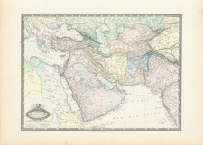
Striking map of the region bounded by the Adriatic, Ionian Sea, Mediterranean, Black Sea and Asia Minor, colored by states, with key and decorative compass rose. Shows towns, rivers, mountains, lakes, etc. A wonderful ephemeral map from the end of the 18th Century. Striking original wash colors. Robert Wilkinson was active in London as a cartographic publisher from 1785 to 1825. He produced a number of nice works, including a General Atlas and a re-issuance of Bowen & Kitchen's English Atlas, along with excellent large format separate maps.
![[ Aegean Sea ]](https://storage.googleapis.com/raremaps/img/small/96557.jpg)
![[ Thessaloniki / Thermaic Gulf ] Die Landschaft Macedonien Nro. 17](https://storage.googleapis.com/raremaps/img/small/102208.jpg)